|
Multibeam Bathymetric and Backscatter Maps of the Upper Hudson Shelf Valley
and Adjacent Shelf, Offshore of New York
Bradford Butman, William W. Danforth, William C. Schwab, and Marilyn Buchholtz
ten Brink
Based on USGS Open File Report 98-616
|
|
|
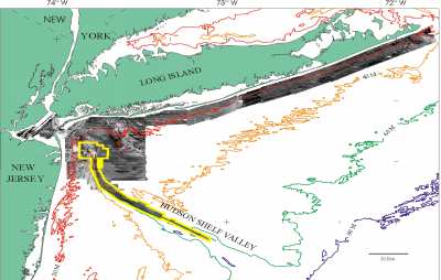
Figure 1. Click for larger image (800 X 509 pixels, 53 Kb)
Map showing location of multibeam survey (yellow outline). The multibeam survey is nested within a sidescan sonar and high-resolution geophysical survey of a larger area (see Schwab and others, 1997a, 1997b) carried out as part of a USGS program to map the surficial geology and shallow subsurface structure offshore of major metropolitan centers. Light tones are high backscatter material (outcropping rock, boulders, gravel and coarse sand), low backscatter material (fine sand, silts and clay) is dark tones. Contours in meters. |
|
The objective of the U.S. Geological Survey mapping project is to map the surficial geology and subsurface
stratigraphy of the Hudson Shelf Valley and adjacent shelf from its head in the Christiansen Basin at about 40° 25' N and 73° 48' W to where it crosses the
outer shelf at about 39° 40' N and 72° 50' W (Fig. 1). The northwesterly area of the survey encompasses a region
of the shelf that may provide sediment to the valley as well as the principal disposal
sites used since the 1800's. The offshore easterly limit of the survey area is 73° W.
The Hudson Shelf Valley (HSV) is the drowned channel of the Hudson River
that was formed at lower stands of sea level. It
extends across the continental shelf from
offshore of New York City towards the shelf
break (Fig. 1). The valley is the principal
topographic feature of the middle Atlantic Bight
and is potentially both a site for accumulation
of sediments as well as a conduit for transport
of sediment across the shelf. In November 1996,
the U.S. Geological Survey (USGS) conducted a
multibeam echosounder survey of the upper HSV
and adjacent shelf (Fig. 1). This multibeam
survey is nested within a sidescan-sonar and
high-resolution geophysical survey of a larger
area (see Schwab and others, 1997a, 1997b). The
surveys were conducted as part of a USGS effort
to map the continental margin offshore of major
metropolitan centers (Gardner and others, 1998)
to provide a regional geologic framework to
address environmental, resource and hazard
issues, and as a basis for sustainable
management of the coastal ocean.
The detailed maps of the geologic
framework and sedimentary environments offshore of New York that have resulted from these
surveys have guided sampling and process studies carried out as part of a USGS study of
the transport and long-term fate of sediments and contaminants in this region (Buchholtz
ten Brink and others, 1998). This progress report presents maps of topography,
acoustic backscatter (a measure of seabed roughness and hardness), and preliminary
interpretations of the sea floor features. An additional multibeam survey to
complete coverage in the HSVis planned for the fall of 1998. The survey
area contains the Dredged Material Disposal Site used for disposal of material from
the New York - New Jersey harbor region. The area was closed to dumping of
contaminated sediments in 1997, and was designated as the Historic Area Remediation Site, where disposal of clean material will cover existing sediments. Two other
disposal sites in the region, one for sewage sludge (the"12 mile site") and one
for cellar dirt, were discontinued in 1987 and 1994 respectively.
Navigate through these Web pages by clicking on the "down," "up," "next,"
or "back" buttons on each page or by using the buttons in the frame at
the left side of the screen. |