Objectives
Basin: Guided Imagery
Facts about the Basin
What is a Watershed?
Where does the water come from?
Precipitation
Groundwater
Surface Runoff
Activities
View Chapter:
Lessons on the Lake

Pontchartrain Basin:
A Watershed

illustration of the Pontchartrain area

Objectives:

  1. Define a watershed.
  2. Describe the relationship between land and water in the watershed.
  3. Describe the Lake Pontchartrain Basin watershed.
  4. Read and understand the features on a topographic map.

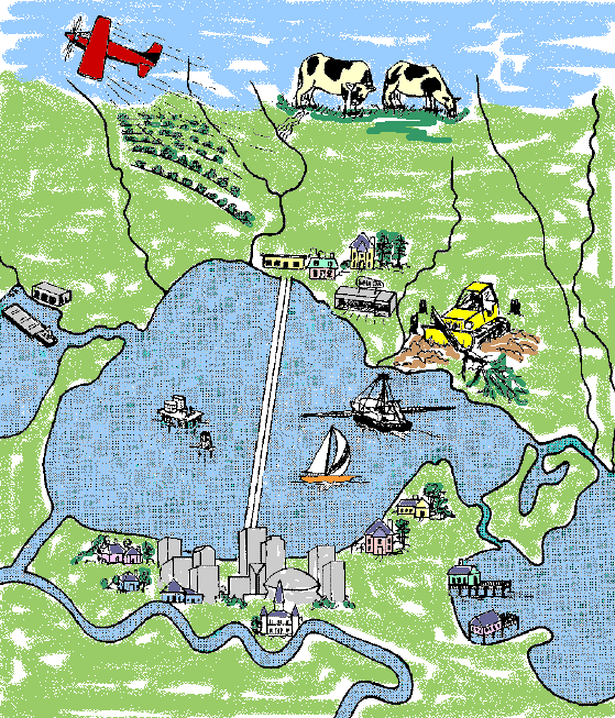
Click for a larger view.

Multiple Intelligences Learning Activities:

Verbal/Linguistic:
Write a script promoting the Lake Pontchartrain Watershed.

Logical/Mathematical:
Construct individual maps of the Lake Pontchartrain Basin.

Visual/Spatial:
Design a watershed and demonstrate its function.
Create posters and programs to publicize and promote the Lake
Pontchartrain Watershed.

Bodily/Kinesthetic:
Dramatize a trip through the Lake Pontchartrain Watershed.

Interpersonal:
Work in cooperative groups designing a watershed, conducting a
survey, and writing, promoting, and producing a play.

Intrapersonal:
Verbally express feelings about the Lake Pontchartrain Basin after listening to a guided imagery.

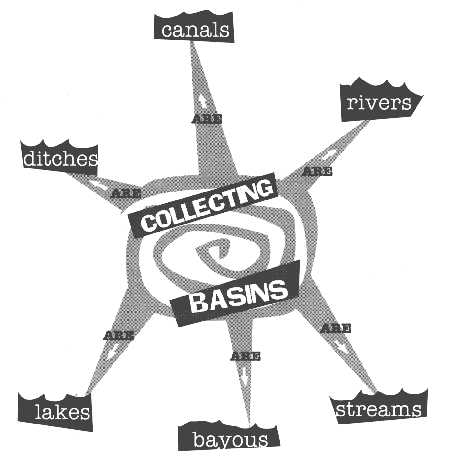
The Lake Pontchartrain Basin:
A Watershed

Guided Imagery

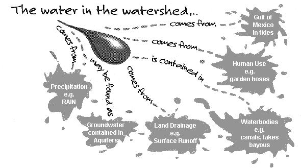
Imagine you are a small stream, a mere trickle of bright clean water, snaking, twisting and turning on your way to the sunny southern coast. Your water spills over rocks and pebbles, smoothing the rough multicolored stones with the force of your rushing water. The soils and sediments you push along the bottom are reddish brown in color, arising from alluvial deposits containing iron compounds. Plop! Plop!... small rocks skip across your surface. Plop! Plop! Smooth stones first skim and then break the surface as they start to sink. Ripples mark the spot; each one larger than the first. The small boys and girls skimming stones turn their attention to other things, and you race down bluff terraces between craggy tree roots and sandy sediments to another dark pool. Here the woods smell of pine. The earth, moist and dark, is covered by thin brown needles and prickly cones. Beside you, a squirrel picks up a newly fallen cone and with great speed tears into the sticky interior in search of newly formed seeds, an afternoon snack perhaps. Your water is dark and quiet; the Native Americans name you, "Tangipahoa." Along your way to the lower coastal plain you now dip, rush, twist and turn, all the while collecting water from the land. Rain dampens green pasture land which harbors black and white dairy cows; it rolls off the purple thistle plants, and the glistening drops cascade over the dark green leaves, finally plunging to the rich moist ground. There, drops gather and form with other drops into a small rivulet which races to the water's edge. As this water enters your gradually enlarging stream, it feeds the bright green grass­like algae growing at the muddy edge-- where bubbles of oxygen float free like balloons during the late night hours--where tiny fish nip at the hairy wisps; snails crawl on the cushiony mat, and black water bugs scamper, dart and spring off the bouncy surface. You now enter Lake Pontchartrain: Lake Pontchartrain, the collecting basin of a large watershed. Not only the water from your own Tangipahoa watershed, but drainage from Lakes Maurepas and Borgne and other small rivers...the Amite, Tickfaw, Tchefuncte, Bogue Falaya, West Pearl Rivers and Bayou Lacombe all contribute water to the great lake, Lake Pontchartrain, where all converge to become one: The Lake Pontchartrain Basin.


Objectives
Basin: Guided Imagery
Facts about the Basin
What is a Watershed?
Where does the water come from?
Precipitation
Groundwater
Surface Runoff
Activities

Facts About the Lake Pontchartrain Basin

  • Another name for the Lake Pontchartrain Basin is the Lake Pontchartrain Watershed.

  • The basin, or watershed, is home to 1.5 million people.

  • The watershed drains the land in 16 parishes in Louisiana and 4 counties in Mississippi.

  • The Louisiana parishes in the Lake Pontchartrain Watershed are: Ascension, East Baton Rouge, East Feliciana, Iberville, Jefferson, Livingston, Orleans, Plaquemines, Tangipahoa, St. Bernard, St. Charles, St. James, St. John the Baptist, St. Helena, St. Tammany, and Washington.

  • Lake Pontchartrain, formed 5000 years ago, is the largest feature of the Lake Pontchartrain Basin.

  • Lake Pontchartrain is not a lake; it is an estuary, or an area in which fresh water from rain and rivers measurably dilutes the salt water from the Gulf of Mexico.

  • Lake Pontchartrain is an entire ecosystem with great biodiversity. An ecosystem is made up of all the living and non­living components of the environment.

What is a Water Shed?

Click any image for a larger view.
sources of water in watershed illustration

  • A watershed is the total land area that contributes runoff to a specific body of water.

  • The runoff is the water which flows off the land surface.

  • The elevation and slope of the land determines which way the surface water will flow.

  • The lowest areas in the watershed that act as collecting basins include rivers, bayous, canals, ditches, streams and lakes.

Lake Pontchartrain Basin

The Lake Pontchartrain Basin is a large watershed covering 700 square miles. In Louisiana the northern border is the Louisiana/Mississippi state line. The basin continues south to the Gulf of Mexico along the east bank of the Mississippi River. The western border of the Basin is the east bank of the Mississippi River, and the eastern boundary is the Pearl River from Washington Parish to Breton Sound.

Where Does the Water in the Watershed Come From?

watershed water sources illustration
  • Precipitation: Precipitation may be in the form of normal rainfall up to 60 inches per year or excessive ainfall events. Other forms of precipitation include sleet, freezing rain, or light snow.

  • Groundwater: Groundwater infiltrates/percolates from surface waters, surrounds sedi-ment particles, and filters through the soil. Trapped groundwater may collect in aquifers, or it may move to the surface by way of wells drilled into aquifers or by seeping from springs.

  • Land Drainage: Precipitation may land on non-absorbent surfaces. This surface runoff drains to lower areas from the streets, down the storm drains, and eventually gets pumped into the lowest area, Lake Pontchartrain.

  • Waterbodies: Canals, lakes, and bayous are some of the water-collecting areas that hold and nnel water in and out of the watershed.

  • Human use: Each person uses approximately 100 gallons of water each day. This water is brought from a water source by pipes. Careless actions by citizens, however, often allow water that is intended for human use to become surface runoff; examples include open or leaky faucets and old cracked pipes.

  • Gulf of Mexico: Waters from the Gulf of Mexico move in and out of the Lake Pontchartrain area on each high and low tide and are blown in by strong easterly winds.

How does precipitation affect the watershed?

precipitation in the watershed illustration

The water from rain runs off the land after heavy rainfall or small showers. This rainwater reaches the surface of the earth and enters the water cycle.

  • The water cycle is an exchange of water molecules through the processes of evaporation, condensation, infiltration and precipitation.

  • Evaporation is the loss of water molecules from the land surface and waterbodies; it supplies the moisture in the atmosphere.

  • This moisture content is known as humidity.

  • Moisture droplets gather together in the atmosphere where they condense around particles of dust or other
    substances.

  • Droplets become heavy, and eventually precipitation (rain) occurs.

How does groundwater affect the watershed?

ground water sources illustration

  • Precipitation soaks into the ground and becomes ground water.

  • Surface water filters through soil and rock before reaching an aquifer.

  • Water in the spaces/openings surrounding soil particles (interstitial) is used for the biological needs of many plants and animals.

  • Aquifers are impounded or enclosed areas which hold the water underground. Many aquifers are tapped by communities for drinking water. Surface waters that become contaminated or polluted may seep into underground aquifers, deteriorating the quality of the water in the watershed.

How does surface runoff affect the watershed?

surface runoff action illustration

  • Surface runoff is water that either does not have time to sink into the ground or is produced in such quantity (e.g., floods) that the normal soaking­up process cannot take place.

  • Water in the form of precipitation runs off the land surface from either grass, soil, or paved areas.

  • The runoff may also drain from open hydrants or hoses.

  • Surface runoff, either from the "first flush," the first inch of a heavy rainfall, or from water draining for a longer time (e.g., a garden hose) carries pollutants, such as motor oil or pesticides, to the waterbodies in the watershed.

  • Responsible actions on the part of citizens can prevent contamination in the watershed. For example, each of us should recycle used motor oil, pick up pet wastes, and properly use pesticides, fertilizers, and herbicides.

Objectives
Basin: Guided Imagery
Facts about the Basin
What is a Watershed?
Where does the water come from?
Precipitation
Groundwater
Surface Runoff
Activities

Activities:


View Chapter:

©1998 Lake Pontchartrain Basin Foundation

Lessons on the Lake is published by the
Lake Pontchartrain Basin Foundation
Metairie, LA

[an error occurred while processing this directive]