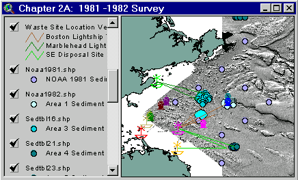
Sample from the ArcView window for Chapter 2a
| Chapter 2A: The 1981-1982 Survey | Return to TABLE OF CONTENTS |
| To view all the coverages described in this Chapter, open the view titled Chapter 2A while running the ArcView project (mbay_30.apr or mbay_31.apr) in the mbaygis directory of this CD-ROM. To view summary metadata (file names, descriptions, provider, references) see the table below. To view complete metadata, go to directory "9_biblio" on this CD-ROM and open the file metadata.mdb using Microsoft Access or the file Gismeta.htm using your browser. |
Sample from the ArcView window for Chapter 2a |
In response to passage of the Marine Protection, Research, and Sanctuaries Act of 1972, as amended (EPA, 1984b), and to Congressional concerns raised during hearings held in Boston (Janes, 1981; USHR, 1981), the NOAA, EPA and FDA conducted a series of surveys at four previously permitted radioactive waste disposal sites in 1981 and 1982. These sites included the Industrial Waste Site (IWS) or Foul Area (Area 1), the Boston Lightship Dumping Ground (Area 2), the Marblehead Light Site (Area 3), and the Southeast Massachusetts Bay Site (Area 5). In addition, the investigation included one reference area (Area 4). A total of 4008 radioactive waste containers were reported as disposed in the bay. The purpose of this survey included locating these containers and assessing the potential risk to human health and the environment. The final report produced by EPA (1984b) presented results of studies that included sidescan sonar surveys of the disposal areas, collections of sediment and biota for radiochemical analysis, collection of seafood samples for a human consumption safety assessment, and a radiological monitoring program to determine whether any concern should be expressed for public health due to the low level radioactive waste disposal. The radiochemical results for biota, edible seafood and sediments were not remarkable and the data has not been included in this CD-ROM. A composite graphic interpretation of the sidescan survey (not included in this GIS) depicted areas of potential waste container targets (EPA, 1984b; Lockwood and others, 1982). Future surveys verified that numerous containers occurred in some of these areas (Wiley and others, 1992; NOAA, 1996).
Coverages provided in Chapter 2A: (Summary metadata for files in the Chapter 2A view are listed alphabetically in the table below. For complete metadata, go to directory "9_biblio" on this CD-ROM and open the file metadata.mdb using Microsoft Access or the file Gismeta.htm using your browser.)
| File Name | Layer Content | Published reference | E-mail of Contact Person | Agency/Organization |
|---|---|---|---|---|
| 1mingrid.shp | One Minute Latitute/Longitude Grid | wwwnurc@uconnvm.uconn.edu | NOAA/NURC | |
| 404water.shp | 404 Boundary Waters off the coast of Mass | seidelc@mtg.saic.com | SAIC | |
| 5mingrid.shp | Five Minute Latitute/Longitude Grid | wwwnurc@uconnvm.uconn.edu | NOAA/NURC | |
| a3_otter.shp | Area 3 Otter trawl tow trackline | John.lindsay@noaa.gov | NOAA/EPA | |
| a4_otter.shp | Area 4 Otter trawl tow trackline | John.lindsay@noaa.gov | NOAA/EPA | |
| a4_rad.shp | Area 4 Radiation sampling | John.lindsay@noaa.gov | NOAA/EPA | |
| a5_otter.shp | Area 5 Otter trawl tow trackline | John.lindsay@noaa.gov | NOAA/EPA | |
| bathy5mb.shp | 5-meter bathymetric contour lines for Western Mass Bay (Quads 19-21) | Butman, B., W. W. Danforth and L. Hayes, Sea Floor Topography and Backscatter of Quadrangles 19-21, Western Massachusetts Bay, Off Boston, Massachusetts, USGS Open-File Report (in prep.) | bbutman@usgs.gov, lhayes@usgs.gov | USGS |
| bathy5sb.shp | 5-meter bathymetric contour lines for Stellwagen Bank (Quads 1-18) | Valentine, P., J. Baker, T. Unger, C. Polloni, 1998, Sea Floor Topographic Map and Perspective-View Imagery of Quadrangles 1-18, Stellwagen Bank National Marine Sanctuary off Boston, Massachusetts, USGS Open-File Report 98-138. | pvalentine@usgs.gov; lhayes@usgs.gov | USGS |
| Buoys_dd.shp | Locations of NOAA Weather Buoys | liebman.matt@epamail.epa.gov | EPA | |
| lights2.shp | Location of Light Houses in Mass Bay | john.lindsay@noaa.gov | NOAA | |
| memanh.shp | Maine, Massachusetts, and New Hampshire state outlines | ESRI Data and Maps - 1996 | john.lindsay@noaa.gov | NOAA/USGS |
| noaa1981.shp | NOAA Sediment Samples | john.lindsay@noaa.gov | NOAA | |
| noaa1982.shp | SAI sediment Samples | john.lindsay@noaa.gov | Science Applications Inc./EPA | |
| noaasurv.shp | NOAA 1980's survey locations | john.lindsay@noaa.gov | NOAA/NOS/OR&R | |
| Sbshd_ng.tif | Shaded Relief for Northern Stellwagen Bank, Geographic coordinates | Valentine, P., T. Unger, J. Baker, and C. Polloni, 1999, Sun-illuminated sea floor topographic maps and perspective-view imagery of Quadrangles 1-18, Stellwagen Bank National Marine Sanctuary off Boston, MA, U.S. Geological Survey Open-File Report 99-363. | pvalentine@usgs.gov | USGS |
| Sbshd_sg.tif | Shaded Relief for Southern Stellwagen Bank, Geographic coordinates | Valentine, P., T. Unger, J. Baker, and C. Polloni, 1999, Sun-illuminated sea floor topographic maps and perspective-view imagery of Quadrangles 1-18, Stellwagen Bank National Marine Sanctuary off Boston, MA, U.S. Geological Survey Open-File Report 99-363. | pvalentine@usgs.gov | USGS |
| sedtbl16.shp | Sediment Samples, Area 3 | john.lindsay@noaa.gov | ||
| sedtbl21.shp | Sediment Sample Locations | john.lindsay@noaa.gov | NOAA | |
| sedtbl23.shp | Sediment Sample Locations | john.lindsay@noaa.gov | ||
| site_vec.shp | Waste Site Location Vectors | EPA reported locations | john.lindsay@noaa.gov | USEPA |
| wmbpsd_g | Pseudocolor image (ARC/INFO grid) Western Massachusetts Bay in Geographic coordinates (see description) | Butman, B., W. W. Danforth and L. Hayes, Sea Floor Topography and Backscatter of Quadrangles 19-21, Western Massachusetts Bay, Off Boston, Massachusetts, USGS Open-File Report (in prep.) | bbutman@usgs.gov, lhayes@usgs.gov | USGS |
| wmbshd_g | Shaded relief map of Western Massachusetts Bay in Geographic coordinates | Butman, B., W. W. Danforth and L. Hayes, Sea Floor Topography and Backscatter of Quadrangles 19-21, Western Massachusetts Bay, Off Boston, Massachusetts, USGS Open-File Report (in prep.) | bbutman@usgs.gov, lhayes@usgs.gov | USGS |
Return to TABLE OF CONTENTS
Continue to CHAPTER 2B
[an error occurred while processing this directive]