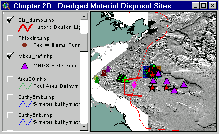
Sample from the ArcView window for Chapter 2D
| Chapter 2D: Dredged Material Disposal Sites |
Return to TABLE OF CONTENTS |
| To view all the coverages described in this Chapter, open the view titled Chapter 2D while running the ArcView project (mbay_30.apr or mbay_31.apr) in the mbaygis directory of this CD-ROM. To view summary metadata (file names, descriptions, provider, references) see the table below. To view complete metadata, go to directory "9_biblio" on this CD-ROM and open the file metadata.mdb using Microsoft Access or the file Gismeta.htm using your browser. |
Sample from the ArcView window for Chapter 2D |
In Massachusetts Bay, three primary dredged material disposal sites have been used since the 1940’s (EPA, 1989a). The earliest sites included areas around the Dumping Ground (DG) buoy and the former Boston Lightship (BLS) Dumping Ground. The DG buoy was moved several times over the years. Around 1963, greater use of the Foul Area disposal site began at a location marked by the "A" buoy. The "A" buoy was relocated in 1975, and remained in place until approximately 1992. In 1977, EPA established the Massachusetts Bay disposal site (MBDS) as a two nautical mile circle in the immediate vicinity of the Foul Area. In 1992, EPA re-designated the MBDS and relocated it slightly to the southwest of the former site. Both of these sites overlapped portions of the Industrial Waste Site, a site used for disposal of a variety of wastes. Two discontinued dumping grounds north of the former BLS Dumping Grounds are shown on the NOAA navigational charts. No information has been located to adequately describe the history or purpose of these dumping grounds.
Excavation materials from the Third Boston Harbor Tunnel, consisting largely of rock, were disposed in the MBDS. This rock and many other features can be seen in the backscatter and shaded relief maps derived from the multibeam echosounder surveys (Valentine, Danforth and others, 1996; Valentine, Baker, Unger, Evans and Polloni, 1998). Prior to this detailed survey, bathymetric and sidescan-sonar surveys of the MBDS were undertaken in 1985, 1988, 1993 and 1996 to define bathymetric contours, and to define the locations of dredged material disposal mounds and other potential targets, such as barrels and wrecks. The 1985 and 1996 survey tracklines are provided to show areal coverage. Interpretations of the 1993 sidescan-sonar records provide an estimate of potential targets acquired by the survey, and image records of some of the significant targets are included via hot link for viewing. An analog laser line scan system, towed over the area in 1993, provided some high resolution imagery of the seafloor.
Several buoys were used over the years at the dredged material disposal site to focus dumping activities. Five reference sites have been routinely sampled to compare sediment chemistry between the dredged material disposal sites and areas outside the influence of disposal operations. The sediment chemistry data are not provided in this CD-ROM.
In 1994, the U.S. Army Corps of Engineers, with field support from Science Applications International Corporation (SAIC), conducted a sediment profile imagery survey of the MBDS.
The Dredged Material Disposal Environment
Some coverages in Chapter 2D include the BLS Dumping Ground boundaries, Massachusetts Bay Disposal Site (MBDS) boundaries, buoys associated with permitted disposal practices, key lights (lighthouses and lightships) associated with site permits, bathymetry, shaded-relief, backscatter and psuedo-colored shaded relief images from the multibeam echosounder surveys, sidescan-sonar image locations; images including wrecks, barrels and bottom scars (can be viewed via hot link), and reference site locations.
The former BLS and IWS 1993
The survey sponsored by ACOE involved towing an analog laser linescan system (LLSS) operated by SAIC (SAIC, 1993a).
Some coverages in Chapter 2D include:
The Massachusetts Bay Disposal Site (MBDS) 1994
The ACOE with field support from SAIC undertook a sediment profile imagery survey of the MBDS (SAIC, 1994b).
Some coverages in Chapter 2D include:
Coverages provided in Chapter 2D: (Summary metadata for files in the Chapter 2D view are listed alphabetically in the table below. For complete metadata, go to directory "9_biblio" on this CD-ROM and open the file metadata.mdb using Microsoft Access or the file Gismeta.htm using your browser.)
| File Name | Layer Content | Published reference | E-mail of Contact Person | Agency/Organization |
|---|---|---|---|---|
| 1mingrid.shp | One Minute Latitute/Longitude Grid | wwwnurc@uconnvm.uconn.edu | NOAA/NURC | |
| 1985ss.shp | Sidescan tracks from Mass Bay Disposal Site Survey | seidelc@mtg.saic.com | SAIC | |
| 3mile.shp | 3 Mile Boundary line off the coast of Mass | seidelc@mtg.saic.com | SAIC | |
| 404water.shp | 404 Boundary Waters off the coast of Mass | seidelc@mtg.saic.com | SAIC | |
| 5mingrid.shp | Five Minute Latitute/Longitude Grid | wwwnurc@uconnvm.uconn.edu | NOAA/NURC | |
| bathy5mb.shp | 5-meter bathymetric contour lines for Western Mass Bay (Quads 19-21) | Butman, B., W. W. Danforth and L. Hayes, Sea Floor Topography and Backscatter of Quadrangles 19-21, Western Massachusetts Bay, Off Boston, Massachusetts, USGS Open-File Report (in prep.) | bbutman@usgs.gov, lhayes@usgs.gov | USGS |
| bathy5sb.shp | 5-meter bathymetric contour lines for Stellwagen Bank (Quads 1-18) | Valentine, P., J. Baker, T. Unger, C. Polloni, 1998, Sea Floor Topographic Map and Perspective-View Imagery of Quadrangles 1-18, Stellwagen Bank National Marine Sanctuary off Boston, Massachusetts, USGS Open-File Report 98-138. | pvalentine@usgs.gov; lhayes@usgs.gov | USGS |
| Bls_dump.shp | Historic Boston Light Ship Disposal Site | NOS #13009, 27th Edition, 8.7.1996, NOS #13267, 28th Edition, 1.25.1997 | john.lindsay@noaa.gov | NOAA/NOS/OR&R |
| Buoys_dd.shp | Locations of NOAA Weather Buoys | liebman.matt@epamail.epa.gov | EPA | |
| dsites.shp | Massachusetts Bay Dredge Material and Interium dredge material disposal sites | EPA Reported locations | john.lindsay@noaa.gov | NOAA/EPA |
| dump_psd | Pseudocolor/Shaded Relief image (ARC/INFO grid) of MassBay disposal site (see description) | Valentine, Baker, Unger, Evans, and Polloni, U.S. Geological Survey Open-File Report 98-344. 1 CD-ROM. Sea Floor Topographic, Backscatter, and Interpretive Maps and Bottom Photos of the Massachusetts Bay Disposal Site region off Boston, MA. | pvalentine@usgs.gov, lhayes@usgs.gov | USGS |
| dump_ss | Backscatter image (ARC/INFO grid) of MassBay disposal site | Valentine, Baker, Unger, Evans, and Polloni, 1998, U.S. Geological Survey Open-File Report 98-344. 1 CD-ROM. Sea Floor Topographic, Backscatter, and Interpretive Maps and Bottom Photos of the Massachusetts Bay Disposal Site region off Boston, MA. | pvalentine@usgs.gov, lhayes@usgs.gov | USGS |
| dump_sun | Shaded Relief image (ARC/INFO grid) of MassBay disposal site | Valentine, Baker, Unger, Evans, and Polloni, 1998, U.S. Geological Survey Open-File Report 98-344. 1 CD-ROM. Sea Floor Topographic, Backscatter, and Interpretive Maps and Bottom Photos of the Massachusetts Bay Disposal Site region off Boston, MA. | pvalentine@usgs.gov, lhayes@usgs.gov | USGS |
| Epass96.shp | Location of sidescan track lines from 1996 | wwwnurc@uconnvm.uconn.edu | NOAA/NURC | |
| fads88.shp | Contour lines from 1988 Survey | SAIC Contribution 79: Valente and Walton, April 1989, Seasonal Monitoring Cruise at the Foul Area Disposal Site, November 1988 - January 1989. | seidelc@mtg.saic.com | SAIC |
| lights2.shp | Location of Light Houses in Mass Bay | john.lindsay@noaa.gov | NOAA | |
| llssimg.shp | Laser Line Scan Image Locations | SAIC Report 294: M.Wiley, September 1993, Laser Linescan System (LLSS) Data Report April 1993. | seidelc@mtg.saic.com | SAIC |
| llssline.shp | Laser Line Scan Tracklines | SAIC Report 294: M.Wiley, September 1993, Laser Linescan System (LLSS) Data Report April 1993. | seidelc@mtg.saic.com | SAIC |
| llsspnt.shp | Laser Line Scan Navigational Points | SAIC Report 294: M.Wiley, September 1993, Laser Linescan System (LLSS) Data Report April 1993. | seidelc@mtg.saic.com | SAIC |
| mbds_pts.shp | Buoys and disposal area centerpoints for the greater Massachusetts Bay Disposal Site (including IWS) | Massachusetts Bay Disposal Site Management Plan dated December 31, 1996 | wwwnurc@uconnvm.uconn.edu | NURC |
| mbds_ref.shp | Mass Bay Disposal Site/Industrial Waste Site Reference Stations | EPA Reported locations, Massachusetts Bay Disposal Site Management Plan | liebman.matt@epamail.epa.gov, thomas.j.fredette@usace.army.mil | USEPA/Region 1 |
| mbds93p.shp | Polygon bathymetry from 1993 Survey | SAIC Report 317: E. DeAngelo & P. Murray, Baseline Survey of the Massachusetts Bay Disposal Site: Final Designation, 14 September 1993. | seidelc@mtg.saic.com | SAIC |
| mbds93ss.shp | Sidescan images from 1993 MBDS survey | SAIC Report 317: E. DeAngelo & P. Murray, Baseline Survey of the Massachusetts Bay Disposal Site: Final Designation, 14 September 1993. | seidelc@mtg.saic.com | SAIC |
| memanh.shp | Maine, Massachusetts, and New Hampshire state outlines | ESRI Data and Maps - 1996 | john.lindsay@noaa.gov | NOAA/USGS |
| misc_ne.shp | New England States | ESRI Data and Maps - 1996 | john.lindsay@noaa.gov | NOAA/USGS |
| remots94.shp | REMOTS sediment profile stations (some with images) | P. Murray, December 1994, Monitoring Cruise at the Massachusetts Bay Disposal Site, August 1994 | seidelc@mtg.saic.com | SAIC |
| Sbshd_ng.tif | Shaded Relief for Northern Stellwagen Bank, Geographic coordinates | Valentine, P.C., Unger, T.S., and Baker, J.L., 1999, Sun-illuminated sea floor topography of the Stellwagen Bank National Marine Sanctuary off Boston, Massachusetts: U.S. Geological Survey Geological Investigations Series Map I-2676-B, 1:60,000. | pvalentine@usgs.gov | USGS |
| Sbshd_sg.tif | Shaded Relief for Southern Stellwagen Bank, Geographic coordinates | Valentine, P.C., Unger, T.S., and Baker, J.L., 1999, Sun-illuminated sea floor topography of the Stellwagen Bank National Marine Sanctuary off Boston, Massachusetts: U.S. Geological Survey Geological Investigations Series Map I-2676-B, 1:60,000. | pvalentine@usgs.gov | USGS |
| Sstarget.shp | Target locations from 1997 Side Scan Mosaic | matthias@coscan.com | Polaris Imaging | |
| thtpoint.shp | Disposal sites for Third Harbor Tunnel project dredge material | memorandum from Tom Fredette (USACE, NED) to Brad Barr (Stellwagen Bank manager) | seidelc@mtg.saic.com | SAIC |
| wmbpsd_g | Pseudocolor image (ARC/INFO grid) Western Massachusetts Bay in Geographic coordinates (see description) | Butman, B., W. W. Danforth and L. Hayes, Sea Floor Topography and Backscatter of Quadrangles 19-21, Western Massachusetts Bay, Off Boston, Massachusetts, USGS Open-File Report (in prep.) | bbutman@usgs.gov, lhayes@usgs.gov | USGS |
| wmbshd_g | Shaded relief map of Western Massachusetts Bay in Geographic coordinates | Butman, B., W. W. Danforth and L. Hayes, Sea Floor Topography and Backscatter of Quadrangles 19-21, Western Massachusetts Bay, Off Boston, Massachusetts, USGS Open-File Report (in prep.) | bbutman@usgs.gov, lhayes@usgs.gov | USGS |
Return to TABLE OF CONTENTS
Continue to CHAPTER 3
[an error occurred while processing this directive]