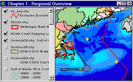
Sample from the ArcView window for Chapter 1
| Chapter 1: Regional Overview |
Return to TABLE OF CONTENTS |
| To view all the coverages described in this Chapter, open the view titled Chapter 1 while running the ArcView project (mbay_30.apr or mbay_31.apr) in the mbaygis directory of this CD-ROM. To view summary metadata (file names, descriptions, provider, references) see the table below. To view complete metadata, go to directory "9_biblio" on this CD-ROM and open the file metadata.mdb using Microsoft Access or the file Gismeta.htm using your browser. |
Sample from the ArcView window for Chapter 1 |
Massachusetts Bay and Cape Cod Bay are located in the western Gulf of Maine. This Chapter presents coverages of the surrounding Gulf of Maine, providing a regional context for coverages of Massachusetts Bay. Some of the coverages included in this view are state and watershed boundaries, boundaries of the exclusive economic zone (EEZ), the Stellwagen Bank National Marine Sanctuary, various areas closed to fishing, shipping lanes into and out of Boston Harbor, and bathymetry of Georges Bank and adjacent Canadian waters. Maps derived from a recent multibeam echosounder survey of the Stellwagen Bank National Marine Sanctuary and western Massachusetts Bay provide a detailed description of the regional surficial geology and provide a new framework for studies of disposal sites, the long-term fate of sediments and contaminants, and biological habitats.
Coverages provided in Chapter 1:
(Summary metadata for files in the Chapter 1 view are listed alphabetically in the table below. For complete metadata, go to directory "9_biblio" on this CD-ROM and open the file metadata.mdb using Microsoft Access or the file Gismeta.htm using your browser.)| File Name | Layer Content | Published reference | E-mail of Contact Person | Agency/Organization |
|---|---|---|---|---|
| 1mingrid.shp | One Minute Latitute/Longitude Grid | wwwnurc@uconnvm.uconn.edu | NOAA/NURC | |
| 5mingrid.shp | Five Minute Latitute/Longitude Grid | wwwnurc@uconnvm.uconn.edu | NOAA/NURC | |
| ca_dcw.shp | Canadian Provinces | ESRI Digital Chart of the World - 1996 | john.lindsay@noaa.gov | NOAA/USGS |
| empirek.shp | Location M/V Empire Knight (Shipwreck) | john.lindsay@noaa.gov | ||
| f_crthab.shp | Right Whale Critical Habitats | Baumann, Carol, Sam Brody, Derek Fenton, and Betsy Nicholson, 1998, A GIS Database of Existing Coastal and Marine Protected Areas, Conservation Zones, and Restricted Fishing Areas in the Gulf of Maine. | cbaumann@cenmarine.com | Center for Marine Conservation, Gulf of Maine Protected Areas Project, Dept of Fisheries and Oceans Canada, Woods Hole Oceanographic Institution |
| f_fish.shp | Federal fishing closures: National Marine Fisheries Service, Department of Fisheries and Oceans | Baumann, Carol, Sam Brody, Derek Fenton, and Betsy Nicholson, 1998, A GIS Database of Existing Coastal and Marine Protected Areas, Conservation Zones, and Restricted Fishing Areas in the Gulf of Maine. | cbaumann@cenmarine.com | Center for Marine Conservation, Gulf of Maine Protected Areas Project, Dept of Fisheries and Oceans Canada, Woods Hole Oceanographic Institution |
| gom15ctr.shp | Contour lines for Gulf of Maine (see description for values contoured). | Roworth, E. and Signell, R., 1999, Construction of digital bathymetry for the Gulf of Maine. U.S. Geological Survey Open-File Report 98-801. 1 CD-ROM. | rsignell@usgs.gov, lhayes@usgs.gov | USGS |
| gom15grd | 15 second grid of Gulf of Maine bathymetry (Geographic) | Roworth, E. and Signell, R., 1999, Construction of digital bathymetry for the Gulf of Maine. U.S. Geological Survey Open-File Report 98-801. 1 CD-ROM. | rsignell@usgs.gov, lhayes@usgs.gov | USGS |
| gom15tfg.tif | 15 second grid of Gulf of Maine bathymetry, converted to tif (Geographic) | Roworth, E. and Signell, R., 1999, Construction of digital bathymetry for the Gulf of Maine. U.S. Geological Survey Open-File Report 98-801. 1 CD-ROM. | rsignell@usgs.gov, lhayes@usgs.gov | USGS |
| gom30grd | 30 second grid of Gulf of Maine bathymetry (Geographic) | Roworth, E. and Signell, R., 1999, Construction of digital bathymetry for the Gulf of Maine. U.S. Geological Survey Open-File Report 98-801. 1 CD-ROM. | rsignell@usgs.gov, lhayes@usgs.gov | USGS |
| gom30tfg.tif | 30 second grid of Gulf of Maine bathymetry, converted to tif (Geographic) | Roworth, E. and Signell, R., 1999, Construction of digital bathymetry for the Gulf of Maine. U.S. Geological Survey Open-File Report 98-801. 1 CD-ROM. | rsignell@usgs.gov, lhayes@usgs.gov | USGS |
| Gomclose.shp | Western Gulf of Maine Closure Area | wwwnurc@uconnvm.uconn.edu | NOAA/NURC | |
| Gomeda24.shp | Watersheds of NOAA's Estuarine Drainage Areas | percy.pacheco@noaa.gov | ORCA, NOAA | |
| Gomhuc24.shp | Watersheds at the USGS Hydrologic Cataloging Level | percy.pacheco@noaa.gov | ORCA, NOAA | |
| Gomsub24.shp | GOM Watersheds at the subbasin level | percy.pacheco@noaa.gov | ORCA, NOAA | |
| memanh.shp | Maine, Massachusetts, and New Hampshire state outlines | ESRI Data and Maps - 1996 | john.lindsay@noaa.gov | NOAA/USGS |
| misc_ne.shp | New England States | ESRI Data and Maps - 1996 | john.lindsay@noaa.gov | NOAA/USGS |
| noaa_gom.kap | NOAA Navigation Chart, NOS #13009, 27th Edition, 8.7.1996 | NOS #13009, 27th Edition, 8.7.1996, digitally produced by Maptech, Inc. | john.lindsay@noaa.gov | NOAA/NOS/CSC |
| noaa_mbg.kap | NOAA Navigation Chart, NOS #13267, 28th Edition, 1.25.1997 | NOS #13267, 28th Edition, 1.25.1997, digitally produced by Maptech, Inc. | john.lindsay@noaa.gov | NOAA/NOS/CSC |
| Noaabuoy.shp | NOAA Marine Environmental Buoys | wwwnurc@uconnvm.uconn.edu | NOAA/NURC | |
| Nurcdive.shp | NURC-NA&GL dive locations for 1995 - 1997 | wwwnurc@uconnvm.uconn.edu | NOAA/NURC | |
| s_fish.shp | State fishing restrictions: mobile and fixed gear regulations (polygons) | Baumann, Carol, Sam Brody, Derek Fenton, and Betsy Nicholson, 1998, A GIS Database of Existing Coastal and Marine Protected Areas, Conservation Zones, and Restricted Fishing Areas in the Gulf of Maine. | cbaumann@cenmarine.com | Center for Marine Conservation, Gulf of Maine Protected Areas Project, Dept of Fisheries and Oceans Canada, Woods Hole Oceanographic Institution |
| s_osanc.shp | State Ocean Sanctuaries | Baumann, Carol, Sam Brody, Derek Fenton, and Betsy Nicholson, 1998, A GIS Database of Existing Coastal and Marine Protected Areas, Conservation Zones, and Restricted Fishing Areas in the Gulf of Maine. | cbaumann@cenmarine.com | Center for Marine Conservation, Gulf of Maine Protected Areas Project, Dept of Fisheries and Oceans Canada, Woods Hole Oceanographic Institution |
| Sbnms.shp | Stellwagen Bank National Marine Sanctuary boundary | Baumann, Carol, Sam Brody, Derek Fenton, and Betsy Nicholson, 1998, A GIS Database of Existing Coastal and Marine Protected Areas, Conservation Zones, and Restricted Fishing Areas in the Gulf of Maine. | cbaumann@cenmarine.com, | Center for Marine Conservation, Gulf of Maine Protected Areas Project, Dept of Fisheries and Oceans Canada, Woods Hole Oceanographic Institution |
| Sbshd_ng.tif | Shaded Relief for Northern Stellwagen Bank, Geographic coordinates | Valentine, P., T. Unger, J. Baker, and C. Polloni, 1999, Sun-illuminated sea floor topographic maps and perspective-view imagery of Quadrangles 1-18, Stellwagen Bank National Marine Sanctuary off Boston, MA, U.S. Geological Survey Open-File Report 99-363. | pvalentine@usgs.gov | USGS |
| Sbshd_sg.tif | Shaded Relief for Southern Stellwagen Bank, Geographic coordinates | Valentine, P., T. Unger, J. Baker, and C. Polloni, 1999, Sun-illuminated sea floor topographic maps and perspective-view imagery of Quadrangles 1-18, Stellwagen Bank National Marine Sanctuary off Boston, MA, U.S. Geological Survey Open-File Report 99-363. | pvalentine@usgs.gov | USGS |
| Sed_poly.shp | Surficial sediment polygons for greater Gulf of Maine | Poppe, L.J., Schlee, J. S., Butman, B., and Lane, C.M., 1989. Map showing distribution of surficial sediment, Gulf of Maine and Georges Bank, Miscellaneous Investigations Series Map, I-1986-A, 1 sheet. | lpoppe@usgs.gov, wwwnurc@uconnvm.uconn.edu | USGS |
| sedfindd.shp | Sedimentary Environments Map | Knebel, H.J. and Circe, R.C., 1995; Knebel, H.J., Rendigs, R.R., List, J.H., and Signell, R.P., 1996; Butman, B. and Bothner, M.H., 1998. (see referen.htm for full references) | hknebel@usgs.gov | USGS |
| shiplane.shp | Shipping lanes, separation lanes and precautionary zones to area Harbors | NOS #13009, 27th Edition, 8.7.96; NOS #13267, 28th Edition, 1.25.97 | john.lindsay@noaa.gov | NOAA/NOS/OR&R |
| Tidegage.shp | Operational Next Generation Water Level Stations | wwwnurc@uconnvm.uconn.edu | NOAA/NURC | |
| us_eez.shp | Exclusive Economic Zone boundary (unofficial) | Twichell, D.C ., and C.F. Polloni, CD-ROM Atlas of the Deepwater Parts of the U.S. Exclusive Economic Zone in the Atlantic Ocean, the Gulf of Mexico, and the Eastern Caribbean Sea, USGS DDS-15, 1993. | cpolloni@usgs.gov | USGS |
| wmbpsd_g | Pseudocolor image (ARC/INFO grid) Western Massachusetts Bay in Geographic coordinates (see description) | Butman, B., W. W. Danforth and L. Hayes, Sea Floor Topography and Backscatter of Quadrangles 19-21, Western Massachusetts Bay, Off Boston, Massachusetts, USGS Open-File Report (in prep.) | bbutman@usgs.gov, lhayes@usgs.gov | USGS |
| wmbshd_g | Shaded relief map of Western Massachusetts Bay in Geographic coordinates | Butman, B., W. W. Danforth and L. Hayes, Sea Floor Topography and Backscatter of Quadrangles 19-21, Western Massachusetts Bay, Off Boston, Massachusetts, USGS Open-File Report (in prep.) | bbutman@usgs.gov, lhayes@usgs.gov | USGS |
Return to TABLE OF CONTENTS
Continue to CHAPTER 2
[an error occurred while processing this directive]