Sample from the ArcView window for Chapter 2
| Chapter 2: Disposal Sites and Survey Locations | Return to
TABLE OF CONTENTS |
| To view all the coverages described in this Chapter, open the view titled Chapter 2 while running the ArcView project (mbay_30.apr or mbay_31.apr) in the mbaygis directory of this CD-ROM. To view summary metadata (file names, descriptions, provider, references) see the table below. To view complete metadata, go to directory "9_biblio" on this CD-ROM and open the file metadata.mdb using Microsoft Access or the file Gismeta.htm using your browser. |
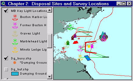
Sample from the ArcView window for Chapter 2 |
Between 1946 and 1992 several sites in Massachusetts Bay were permitted for the disposal of industrial chemical and low-level radioactive wastes (LLW), dredged materials, munitions and explosives, and debris, including derelict vessels and construction materials. The EPA (Tordoff, 1991a-d) provided a compilation of most disposal site reference points. These points included buoys, lighthouses, lightships, and other landmarks and coordinates. Some of these points, such as the Dumping Ground ("DG") buoy, had been positioned at several locations over the years. Both the "DG" buoy and the Boston Lightship no longer exist, yet the former locations of these and other markers played critical roles in the designation of dumping areas and in directing investigations. The following is a brief description of the categories of wastes disposed in Massachusetts Bay and a description of disposal areas that are in this GIS.
Dredged materials were disposed in several areas, including the DG buoy, historic dumpsites, the Boston Lightship Dumping Grounds, the Foul Area/Foul Grounds, the "Interim" Massachusetts Bay Disposal Site, and the final Massachusetts Bay Disposal Site.
Industrial Chemical Wastes have been permitted for disposal in the bay at the Boston Lightship Dumping Ground, the Foul Area/Foul Grounds and later the Industrial Waste Site.
Low-level radio active wastes (LLW) were permitted for disposal at four sites and may also have been disposed around the "DG" buoy prior to permitting. Disposal sites for LLW include the Boston Lightship Dumping Ground, the Marblehead Light Site, the Southeast Massachusetts Bay Site, the Foul Area/Foul Grounds and later the Industrial Waste Site.
Records regarding the establishment of munitions and explosives disposal areas have not yet been located, but NOAA charts depicting reported locations of unexploded ordnance (UXOs) and one letter written by NOAA indicate that such materials have been dumped at the Foul Grounds/Foul Area, the North Dump Site, the Central Dump Site, and numerous locations throughout the bay and Gulf of Maine.
Construction debris and derelict vessels may have ended up at numerous locations throughout the bay, but accepted, if not permitted areas for disposal of vessels include the Foul Area and the Boston Lightship Dumping Ground.
Historic Dumpsites (see ArcView shapefile dumpsite.shp): Three discontinued disposal sites are designated on various NOAA charts in western Massachusetts Bay.
The Foul Area and Industrial Waste Site (IWS) (see ArcView shapefiles iws_site.shp, mbds_pts.shp): The Foul Area or Foul Grounds, was renamed the Industrial Waste Site (IWS) in 1977. The former names were derived from the material on the bottom that "fouls" or tears fishermen’s nets (EPA, 1989a). The Foul Area was designated as a munitions disposal area in 1945 (NOAA, 1992). On the present NOAA Charts it is identified with an "Explosives" designation. The Foul Area described as a point 056° True, 9.3 nm from the Boston Lightship (Tordoff, 1991b) was also designated for LLW, chemical, and toxic wastes in March 1957; although, a licensed disposal operator was directed to dump LLW materials in the Foul Area as early as December 1952 (USHR, 1981). On 16 September 1957, the U.S. Coast Guard set an Orange and White Buoy in the "Foul Area Explosives-Northern Edge" (Tordoff, 1991a). This lighted buoy was later moved to the center of the Foul Area.
The Massachusetts Bay Disposal Site (MBDS) (see ArcView shapefiles dsites.shp, mbds_pts.shp): Between 1977-1992, an interim Massachusetts Bay Disposal Site (MBDS) for dredged materials was designated that partially overlapped the IWS. In 1993, a final MDBS was designated as an ocean disposal site, which continued to overlap the IWS but in a more southerly orientation than did the interim site.
Just as a fisherman allegedly redumped a LLW container near the "DG" buoy in 1978, others have alleged that they caught LLW containers in their drag nets (Tordoff, 1991b,c). To avoid recapturing these containers, several fishermen claimed to have redumped these containers in a rocky ledge area off of Cohasset. The potential area harboring these redumped containers has been termed the Cohasset Redump area.
Dredged Material Disposal: The Foul Area served as a permitted repository for dredged materials from the 1940’s to 1977. In 1977, the "Foul Grounds" became known as the Industrial Waste Site (IWS). Between 1977-1992, an interim Massachusetts Bay Disposal Site (MBDS) for dredged materials was designated that partially overlapped the IWS. In 1993, a final MDBS was designated as an ocean disposal site, which continued to overlap the IWS but in a more southerly orientation than did the interim site. Numerous investigations, as summarized by ACOE (1988) and EPA (1989a,c, and 1992a) provided considerable information about these areas. Only a small portion of the available information is included in this GIS. Three discontinued disposal sites are designated on various NOAA charts in western Massachusetts Bay and individual high-backscatter dumps of material are evident in backscatter views in the vicinity of the two former "DG" buoy locations and the southern discontinued disposal site.
The Subchapters
Information gathered from various waste disposal site surveys in Massachusetts Bay is presented in four subchapters:
2A: The 1981-82 Survey conducted by NOAA, EPA and the Food and Drug Administration at potential radioactive waste disposal sites;
2B: The 1990’s Industrial Waste Site Surveys that examined the fate and effects of chemical and radioactive waste disposal;
2C: Former Boston Lightship Dumping Ground Surveys of the 1990’s that focused on locating radioactive waste containers;
2D: Dredged Material Disposal Sites that focused on dredged material disposal in Massachusetts Bay.
Coverages provided in Chapter 2: (Summary metadata for files in the Chapter 2 view are listed alphabetically in the table below. For complete metadata, go to directory "9_biblio" on this CD-ROM and open the file metadata.mdb using Microsoft Access or the file Gismeta.htm using your browser.)
| File Name | Layer Content | Published reference | E-mail of Contact Person | Agency/Organization |
|---|---|---|---|---|
| 1mingrid.shp | One Minute Latitute/Longitude Grid | wwwnurc@uconnvm.uconn.edu | NOAA/NURC | |
| 3mile.shp | 3 Mile Boundary line off the coast of Mass | seidelc@mtg.saic.com | SAIC | |
| 404water.shp | 404 Boundary Waters off the coast of Mass | seidelc@mtg.saic.com | SAIC | |
| 5mingrid.shp | Five Minute Latitute/Longitude Grid | wwwnurc@uconnvm.uconn.edu | NOAA/NURC | |
| Buoys_dd.shp | Locations of NOAA Weather Buoys | liebman.matt@epamail.epa.gov | EPA | |
| cohass.shp | Cohasset Redump Area | john.lindsay@noaa.gov | ||
| dg_buf.shp | Dumping Ground | john.lindsay@noaa.gov | NOAA | |
| dg_buoy.shp | "Dumping Ground" Bell Buoy | john.lindsay@noaa.gov | NOAA | |
| dsites.shp | Massachusetts Bay Dredge Material and Interium dredge material disposal sites | EPA Reported locations | john.lindsay@noaa.gov | NOAA/EPA |
| dumpsite.shp | Areas used for IW, DM, and Munitions dumping | NOS #13009, 27th Edition, 8.7.1996 | john.lindsay@noaa.gov | NOAA/NOS |
| iws_clse.shp | Industrial Waste Site Closure Area for Surface Clams and Quahogs | john.lindsay@noaa.gov | NOAA/NOS/OR&R | |
| iws_site.shp | Mass Bay IWS and SE Radioactive waste dump sites | Reported locations and NOS #13267, 28th Edition, 1.25.1997, digitally produced by Maptech, Inc. | john.lindsay@noaa.gov | NOAA/NOS/OR&R |
| lights2.shp | Location of Light Houses in Mass Bay | john.lindsay@noaa.gov | NOAA | |
| mbds_pts.shp | Buoys and disposal area centerpoints for the greater Massachusetts Bay Disposal Site (including IWS) | Massachusetts Bay Disposal Site Management Plan dated December 31, 1996 | wwwnurc@uconnvm.uconn.edu | NURC |
| memanh.shp | Maine, Massachusetts, and New Hampshire state outlines | ESRI Data and Maps - 1996 | john.lindsay@noaa.gov | NOAA/USGS |
| mwra_out.shp | Locations of Waste diffuser outfalls | john.lindsay@noaa.gov | Massachusetts Water Resource Authority | |
| Noaabuoy.shp | NOAA Marine Environmental Buoys | wwwnurc@uconnvm.uconn.edu | NOAA/NURC | |
| noaasurv.shp | NOAA 1980's survey locations | john.lindsay@noaa.gov | NOAA/NOS/OR&R | |
| site_vec.shp | Waste Site Location Vectors | EPA reported locations | john.lindsay@noaa.gov | USEPA |
| surveys.shp | Potential Radioactive Waste Survey Areas | EPA Reported locations of Potential survey areas | john.lindsay@noaa.gov | NOAA/EPA |
| uxo_site.shp | Location of Unexploded ordinance reported and Explosive Dump Sites | NOAA Chart 13009, GOM and George's Bank(27th Ed., 8/98)/NOAA Chart 13267, Massachusetts Bay (28th Ed., 1/25/97) | john.lindsay@noaa.gov | NOAA |
Return to TABLE OF CONTENTS
Continue to CHAPTER 2A
[an error occurred while processing this directive]