Sample from the ArcView window for Chapter 4
Chapter 4: Stellwagen Bank National Marine Sanctuary
Return to TABLE OF CONTENTS
Continue to LIBRARY 1
| To view all the coverages described in this Chapter, open the view titled Chapter 4 while running the ArcView project (mbay_30.apr or mbay_31.apr) in the mbaygis directory of this CD-ROM. To view summary metadata (file names, descriptions, provider, references) see the table below. To view complete metadata, go to directory "9_biblio" on this CD-ROM and open the file metadata.mdb using Microsoft Access or the file Gismeta.htm using your browser. |
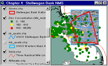
Sample from the ArcView window for Chapter 4 |
The Stellwagen Bank National Marine Sanctuary (SBNMS) was designated in 1993. North Atlantic Right whales, an endangered species, spend time in Cape Cod Bay and the Stellwagen Bank region in the spring. The USGS, in cooperation with NOAA, the Canadian Hydrographic Service and the University of New Brunswick (Valentine and Butman, 1998; see library 3) has systematically mapped the sea floor using a multibeam echosounder. These surveys provide a detailed view of the topography and surficial geology of the sea floor. A major concern has been that the effluent from the new MWRA ocean outfall in western Massachusetts Bay will impact endangered species in the Sanctuary. Effluent dilution estimates, based on a three dimensional hydrodynamic model (Signell, 1997; Signell and others, 1996), show that the concentration of effluent in the Stellwagen Bank National Marine Sanctuary (and most of Massachusetts Bay) from the new outfall will not significantly differ from present concentrations. This reflects the fact that much of the effluent presently discharged in Boston Harbor is transported to western Massachusetts Bay, and that the Sanctuary is far enough from the effluent source so that the change in the location of the initial release is masked by the mixing processes in Massachusetts Bay.
This Chapter/view includes relevant boundaries, topography and shaded relief images from the multibeam echosounder surveys, sediment texture, selected sediment chemistry, fisheries abundance data for selected species (juveniles and adults), critical habitats, and the effluent dilution estimates for winter and summer.
Coverages provided in Chapter 4: (Sumary metadta for files in the Chapter 2D view are listed alphabetically in the table below. For complete metadata, go to the directory "9_biblio" on this CD-ROM and open the file metadata.mdb using Microsoft Access or the file Gismeta.htm using your browser.)
| File Name | Layer Content | Published reference | E-mail of Contact Person | Agency/Organization |
|---|---|---|---|---|
| 1mingrid.shp | One Minute Latitute/Longitude Grid | wwwnurc@uconnvm.uconn.edu | NOAA/NURC | |
| 3mile.shp | 3 Mile Boundary line off the coast of Mass | seidelc@mtg.saic.com | SAIC | |
| 404water.shp | 404 Boundary Waters off the coast of Mass | seidelc@mtg.saic.com | SAIC | |
| 5mingrid.shp | Five Minute Latitute/Longitude Grid | wwwnurc@uconnvm.uconn.edu | NOAA/NURC | |
| bathy5mb.shp | 5-meter bathymetric contour lines for Western Mass Bay (Quads 19-21) | Butman, B., W. W. Danforth and L. Hayes, Sea Floor Topography and Backscatter of Quadrangles 19-21, Western Massachusetts Bay, Off Boston, Massachusetts, USGS Open-File Report (in prep.) | bbutman@usgs.gov, lhayes@usgs.gov | USGS |
| bathy5sb.shp | 5-meter bathymetric contour lines for Stellwagen Bank (Quads 1-18) | Valentine, P., J. Baker, T. Unger, C. Polloni, 1998, Sea Floor Topographic Map and Perspective-View Imagery of Quadrangles 1-18, Stellwagen Bank National Marine Sanctuary off Boston, Massachusetts, USGS Open-File Report 98-138. | pvalentine@usgs.gov; lhayes@usgs.gov | USGS |
| bb02sumg | Simulated effluent concentrations from Boston's sewage outfall: Bay Outfall, Summer, 2 m below surface | Signell, R.P., H.L. Jenter and A.F. Blumberg, 1996, "Circulation and Effluent Dilution Modeling in Massachusetts Bay: Model Implementation, Verification, and Results", USGS Open File Report 96-015, 121 pages. | rsignell@usgs.gov | USGS |
| bb02sumg.tif | Simulated effluent concentrations from Boston's sewage outfall: Bay Outfall, Summer, 2 m below surface | Signell, R.P., H.L. Jenter and A.F. Blumberg, 1996, "Circulation and Effluent Dilution Modeling in Massachusetts Bay: Model Implementation, Verification, and Results", USGS Open File Report 96-015, 121 pages. | rsignell@usgs.gov | USGS |
| bb02wing | Simulated effluent concentrations from Boston's sewage outfall: Bay Outfall, Winter, 2 m below surface | Signell, R.P., H.L. Jenter and A.F. Blumberg, 1996, "Circulation and Effluent Dilution Modeling in Massachusetts Bay: Model Implementation, Verification, and Results", USGS Open File Report 96-015, 121 pages. | rsignell@usgs.gov | USGS |
| bb02wing.tif | Simulated effluent concentrations from Boston's sewage outfall: Bay Outfall, Winter, 2 m below surface | Signell, R.P., H.L. Jenter and A.F. Blumberg, 1996, "Circulation and Effluent Dilution Modeling in Massachusetts Bay: Model Implementation, Verification, and Results", USGS Open File Report 96-015, 121 pages. | rsignell@usgs.gov | USGS |
| bb16sumg | Simulated effluent concentrations from Boston's sewage outfall: Bay Outfall, Summer, 16 m below surface | Signell, R.P., H.L. Jenter and A.F. Blumberg, 1996, "Circulation and Effluent Dilution Modeling in Massachusetts Bay: Model Implementation, Verification, and Results", USGS Open File Report 96-015, 121 pages. | rsignell@usgs.gov | USGS |
| bb16sumg.tif | Simulated effluent concentrations from Boston's sewage outfall: Bay Outfall, Summer, 16 m below surface | Signell, R.P., H.L. Jenter and A.F. Blumberg, 1996, "Circulation and Effluent Dilution Modeling in Massachusetts Bay: Model Implementation, Verification, and Results", USGS Open File Report 96-015, 121 pages. | rsignell@usgs.gov | USGS |
| bb16wing | Simulated effluent concentrations from Boston's sewage outfall: Bay Outfall, Winter, 16 m below surface | Signell, R.P., H.L. Jenter and A.F. Blumberg, 1996, "Circulation and Effluent Dilution Modeling in Massachusetts Bay: Model Implementation, Verification, and Results", USGS Open File Report 96-015, 121 pages. | rsignell@usgs.gov | USGS |
| bb16wing.tif | Simulated effluent concentrations from Boston's sewage outfall: Bay Outfall, Winter, 16 m below surface | Signell, R.P., H.L. Jenter and A.F. Blumberg, 1996, "Circulation and Effluent Dilution Modeling in Massachusetts Bay: Model Implementation, Verification, and Results", USGS Open File Report 96-015, 121 pages. | rsignell@usgs.gov | USGS |
| ca_dcw.shp | Canadian Provinces | ESRI Digital Chart of the World - 1996 | john.lindsay@noaa.gov | NOAA/USGS |
| dr02sumg |
Simulated effluent concentrations from Boston's sewage outfall: Harbor Outfalls, Summer, 2 m below surface | Signell, R.P., H.L. Jenter and A.F. Blumberg, 1996, "Circulation and Effluent Dilution Modeling in Massachusetts Bay: Model Implementation, Verification, and Results", USGS Open File Report 96-015, 121 pages. | rsignell@usgs.gov | USGS |
| dr02sumg.tif | Simulated effluent concentrations from Boston's sewage outfall: Harbor Outfalls, Summer, 2 m below surface | Signell, R.P., H.L. Jenter and A.F. Blumberg, 1996, "Circulation and Effluent Dilution Modeling in Massachusetts Bay: Model Implementation, Verification, and Results", USGS Open File Report 96-015, 121 pages. | rsignell@usgs.gov | USGS |
| dr02wing | Simulated effluent concentrations from Boston's sewage outfall: Harbor Outfalls, Winter, 2 m below surface | Signell, R.P., H.L. Jenter and A.F. Blumberg, 1996, "Circulation and Effluent Dilution Modeling in Massachusetts Bay: Model Implementation, Verification, and Results", USGS Open File Report 96-015, 121 pages. | rsignell@usgs.gov | USGS |
| dr02wing.tif | Simulated effluent concentrations from Boston's sewage outfall: Harbor Outfalls, Winter, 2 m below surface | Signell, R.P., H.L. Jenter and A.F. Blumberg, 1996, "Circulation and Effluent Dilution Modeling in Massachusetts Bay: Model Implementation, Verification, and Results", USGS Open File Report 96-015, 121 pages. | rsignell@usgs.gov | USGS |
| dr16sumg | Simulated effluent concentrations from Boston's sewage outfall: Harbor Outfalls, Summer, 16 m below surface | Signell, R.P., H.L. Jenter and A.F. Blumberg, 1996, "Circulation and Effluent Dilution Modeling in Massachusetts Bay: Model Implementation, Verification, and Results", USGS Open File Report 96-015, 121 pages. | rsignell@usgs.gov | USGS |
| dr16sumg.tif | Simulated effluent concentrations from Boston's sewage outfall: Harbor Outfalls, Summer, 16 m below surface | Signell, R.P., H.L. Jenter and A.F. Blumberg, 1996, "Circulation and Effluent Dilution Modeling in Massachusetts Bay: Model Implementation, Verification, and Results", USGS Open File Report 96-015, 121 pages. | rsignell@usgs.gov | USGS |
| dr16wing | Simulated effluent concentrations from Boston's sewage outfall: Harbor Outfalls, Winter, 16 m below surface | Signell, R.P., H.L. Jenter and A.F. Blumberg, 1996, "Circulation and Effluent Dilution Modeling in Massachusetts Bay: Model Implementation, Verification, and Results", USGS Open File Report 96-015, 121 pages. | rsignell@usgs.gov | USGS |
| dr16wing.tif | Simulated effluent concentrations from Boston's sewage outfall: Harbor Outfalls, Winter, 16 m below surface | Signell, R.P., H.L. Jenter and A.F. Blumberg, 1996, "Circulation and Effluent Dilution Modeling in Massachusetts Bay: Model Implementation, Verification, and Results", USGS Open File Report 96-015, 121 pages. | rsignell@usgs.gov | USGS |
| dsites.shp | Massachusetts Bay Dredge Material and Interium dredge material disposal sites | EPA Reported locations | john.lindsay@noaa.gov | NOAA/EPA |
| dump_psd | Pseudocolor/Shaded Relief image (ARC/INFO grid) of MassBay disposal site (see description) | Valentine, Baker, Unger, Evans, and Polloni, 1998, U.S. Geological Survey Open-File Report 98-344. 1 CD-ROM. Sea Floor Topographic, Backscatter, and Interpretive Maps and Bottom Photos of the Massachusetts Bay Disposal Site region off Boston, MA. | pvalentine@usgs.gov, lhayes@usgs.gov | USGS |
| dump_ss | Backscatter image (ARC/INFO grid) of MassBay disposal site | Valentine, Baker, Unger, Evans, and Polloni, 1998, U.S. Geological Survey Open-File Report 98-344. 1 CD-ROM. Sea Floor Topographic, Backscatter, and Interpretive Maps and Bottom Photos of the Massachusetts Bay Disposal Site region off Boston, MA. | pvalentine@usgs.gov, lhayes@usgs.gov | USGS |
| dump_sun | Shaded Relief image (ARC/INFO grid) of MassBay disposal site | Valentine, Baker, Unger, Evans, and Polloni, 1998, U.S. Geological Survey Open-File Report 98-344. 1 CD-ROM. Sea Floor Topographic, Backscatter, and Interpretive Maps and Bottom Photos of the Massachusetts Bay Disposal Site region off Boston, MA. | pvalentine@usgs.gov, lhayes@usgs.gov | USGS |
| f_crthab.shp | Right Whale Critical Habitats | Baumann, Carol, Sam Brody, Derek Fenton, and Betsy Nicholson, 1998, A GIS Database of Existing Coastal and Marine Protected Areas, Conservation Zones, and Restricted Fishing Areas in the Gulf of Maine. | cbaumann@cenmarine.com | Center for Marine Conservation, Gulf of Maine Protected Areas Project, Dept of Fisheries and Oceans Canada, Woods Hole Oceanographic Institution |
| fish_ma.shp | Data collected during Massachusetts Division of Marine Fisheries (MA-DMF) groundfish surveys, 1978 - 1997, spring & fall | A series of reports are in final stages of preparation. Each is entitled "Essential Fish Habitat Source Documents: [species name], Life History and Habitat Characteristics" | Christine.Zetlin@noaa.gov | NMFS/NEFSC/James J. Howard Laboratory |
| fish_nef.shp | Data collected during Northeast Fisheries Science Center (NEFSC) groundfish surveys, 1978 - 1997, spring & fall | A series of reports are in final stages of preparation. Each is entitled "Essential Fish Habitat Source Documents: [species name], Life History and Habitat Characteristics" | Christine.Zetlin@noaa.gov | NMFS/NEFSC/James J. Howard Laboratory |
| iws_site.shp | Mass Bay IWS and SE Radioactive waste dump sites | Reported locations and NOS #13267, 28th Edition, 1.25.1997, digitally produced by Maptech, Inc. | john.lindsay@noaa.gov | NOAA/NOS/OR&R |
| MB_mets.shp | Copper and Zinc concentrations in surface sediments | Buchholtz ten Brink, M.R. and others, Contaminated sediments database for the Gulf of Maine. U.S. Geological Survey Open-File Report. Web publication and CD-ROM. (in prep.) (see referen.htm for full list of authors) | mtenbrink@usgs.gov, emecray@usgs.gov | USGS |
| mb_quads.shp | USGS Quadrangle boundaries for quads 19-21 | Butman, B., W. W. Danforth and L. Hayes, Sea Floor Topography and Backscatter of Quadrangles 19-21, Western Massachusetts Bay, Off Boston, Massachusetts, USGS Open-File Report (in prep.) | bbutman@usgs.gov, lhayes@usgs.gov | USGS |
| MB_text.shp | Surficial sediment texture, USGS Atlantic Margin Database | Buchholtz ten Brink, M.R. and others, Contaminated sediments database for the Gulf of Maine. U.S. Geological Survey Open-File Report. Web publication and CD-ROM. (in prep.) (see referen.htm for full list of authors) | phastings@usgs.gov | USGS |
| memanh.shp | Maine, Massachusetts, and New Hampshire state outlines | ESRI Data and Maps - 1996 | john.lindsay@noaa.gov | NOAA/USGS |
| s_osanc.shp | State Ocean Sanctuaries | Baumann, Carol, Sam Brody, Derek Fenton, and Betsy Nicholson, 1998, A GIS Database of Existing Coastal and Marine Protected Areas, Conservation Zones, and Restricted Fishing Areas in the Gulf of Maine. | cbaumann@cenmarine.com | Center for Marine Conservation, Gulf of Maine Protected Areas Project, Dept of Fisheries and Oceans Canada, Woods Hole Oceanographic Institution |
| sb_quads.shp | USGS Quadrangle boundaries for quads 1-18 | Valentine, P., J. Baker, T. Unger, C. Polloni, 1998, Sea Floor Topographic Map and Perspective-View Imagery of Quadrangles 1-18, Stellwagen Bank National Marine Sanctuary off Boston, Massachusetts, USGS Open-File Report 98-138. | pvalentine@usgs.gov | USGS |
| Sbnms.shp | Stellwagen Bank National Marine Sanctuary boundary | Baumann, Carol, Sam Brody, Derek Fenton, and Betsy Nicholson, 1998, A GIS Database of Existing Coastal and Marine Protected Areas, Conservation Zones, and Restricted Fishing Areas in the Gulf of Maine. | cbaumann@cenmarine.com | Center for Marine Conservation, Gulf of Maine Protected Areas Project, Dept of Fisheries and Oceans Canada, Woods Hole Oceanographic Institution |
| Sbnms_b.shp | Stellwagen Bank National Marine Sanctuary 1000m buffer | |||
| Sbshd_ng.tif | Shaded Relief for Northern Stellwagen Bank, Geographic coordinates | Valentine, P., T. Unger, J. Baker, and C. Polloni, 1999, Sun-illuminated sea floor topographic maps and perspective-view imagery of Quadrangles 1-18, Stellwagen Bank National Marine Sanctuary off Boston, MA, U.S. Geological Survey Open-File Report 99-363. | pvalentine@usgs.gov | USGS |
| Sbshd_sg.tif | Shaded Relief for Southern Stellwagen Bank, Geographic coordinates | Valentine, P., T. Unger, J. Baker, and C. Polloni, 1999, Sun-illuminated sea floor topographic maps and perspective-view imagery of Quadrangles 1-18, Stellwagen Bank National Marine Sanctuary off Boston, MA, U.S. Geological Survey Open-File Report 99-363. | pvalentine@usgs.gov | USGS |
| shiplane.shp | Shipping lanes, separation lanes and precautionary zones to area Harbors | NOS #13009, 27th Edition, 8.7.96; NOS #13267, 28th Edition, 1.25.97 | john.lindsay@noaa.gov | NOAA/NOS/OR&R |
| Stel_bio.shp | Federal Fishing Closures in the greater Gulf of Maine | |||
| stell_dd | Gridded bathymetry | cpolloni@usgs.gov, pvalentine@usgs.gov | USGS | |
| wmbpsd_g | Pseudocolor image (ARC/INFO grid) Western Massachusetts Bay in Geographic coordinates (see description) | Butman, B., W. W. Danforth and L. Hayes, Sea Floor Topography and Backscatter of Quadrangles 19-21, Western Massachusetts Bay, Off Boston, Massachusetts, USGS Open-File Report (in prep.) | bbutman@usgs.gov, lhayes@usgs.gov | USGS |
| wmbshd_g | Shaded relief map of Western Massachusetts Bay in Geographic coordinates | Butman, B., W. W. Danforth and L. Hayes, Sea Floor Topography and Backscatter of Quadrangles 19-21, Western Massachusetts Bay, Off Boston, Massachusetts, USGS Open-File Report (in prep.) | bbutman@usgs.gov, lhayes@usgs.gov | USGS |
Return to TABLE OF CONTENTS
Continue to LIBRARY 1
[an error occurred while processing this directive]