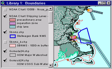
Sample from the ArcView window for Library 1
| Library 1: Boundaries |
Return to TABLE OF CONTENTS |
| To view all the coverages described in this Library, open the view titled Library 1 while running the ArcView project (mbay_30.apr or mbay_31.apr) in the mbaygis directory of this CD-ROM. To view summary metadata (file names, descriptions, provider, references) see the table below. To view complete metadata, go to directory "9_biblio" on this CD-ROM and open the file metadata.mdb using Microsoft Access or the file Gismeta.htm using your browser. |
Sample from the ArcView window for Library 1 |
Relevant marine boundaries are a critical component of any survey activity, environmental assessment or map interpretation. They guide historical reviews of disposal activity, define jurisdictional areas, and provide consistent reference points to compare data sets. Several compilations of boundaries and reference points exist in paper form (Tordoff, 1991a-d) as well as in GIS format (see Baumann and others, 1998). Note that boundaries, reference points, and landmarks associated with waste disposal in Massachusetts Bay are in Library 2 (Waste Site Features).
Coverages provided in Library 1: (Summary metadata for files in the Library 1 view are listed alphabetically in the table below. For complete metadata, go to directory "9_biblio" on this CD-ROM and open the file metadata.mdb using Microsoft Access or the file Gismeta.htm using your browser.)
| File Name | Layer Content | Published reference | E-mail of Contact Person | Agency/Organization |
|---|---|---|---|---|
| 01090001.shp | USEPA RF3 Hydrology | USEPA Reach File 3, 1:100,000 Hydrology | john.lindsay@noaa.gov | USEPA |
| 1mingrid.shp | One Minute Latitute/Longitude Grid | wwwnurc@uconnvm.uconn.edu | NOAA/NURC | |
| 3mile.shp | 3 Mile Boundary line off the coast of Mass | seidelc@mtg.saic.com | SAIC | |
| 404water.shp | 404 Boundary Waters off the coast of Mass | seidelc@mtg.saic.com | SAIC | |
| 5mingrid.shp | Five Minute Latitute/Longitude Grid | wwwnurc@uconnvm.uconn.edu | NOAA/NURC | |
| Buoys_dd.shp | Locations of NOAA Weather Buoys | liebman.matt@epamail.epa.gov | EPA | |
| ca_dcw.shp | Canadian Provinces | ESRI Digital Chart of the World - 1996 | john.lindsay@noaa.gov | NOAA/USGS |
| Contig_z.shp | ||||
| ec80arc.shp | Massachusetts Shoreline | received from Stellwagen Bank Information System web site | seidelc@mtg.saic.com | SAIC |
| fish_rok.shp | Rocky Bottom Areas | US Dept. of Commerce, NOAA, NOS 1986 - Provincetown Bathymetric Fishing Map | john.lindsay@noaa.gov | NOAA |
| Gom_ca.shp | Canadian landforms adjacent to the Gulf of Maine | |||
| Gomclose.shp | Western Gulf of Maine Closure Area | wwwnurc@uconnvm.uconn.edu | NOAA/NURC | |
| Gomeda24.shp | Watersheds of NOAA's Estuarine Drainage Areas | percy.pacheco@noaa.gov | ORCA, NOAA | |
| Gomhuc24.shp | Watersheds at the USGS Hydrologic Cataloging Level | percy.pacheco@noaa.gov | ORCA, NOAA | |
| Gomsub24.shp | GOM Watersheds at the subbasin level | percy.pacheco@noaa.gov | ORCA, NOAA | |
| lights2.shp | Location of Light Houses in Mass Bay | john.lindsay@noaa.gov | NOAA | |
| mb_quads.shp | USGS Quadrangle boundaries for quads 19-21 | Butman, B., W. W. Danforth and L. Hayes, Sea Floor Topography and Backscatter of Quadrangles 19-21, Western Massachusetts Bay, Off Boston, Massachusetts, USGS Open-File Report (in prep.) | bbutman@usgs.gov, lhayes@usgs.gov | USGS |
| memanh.shp | Maine, Massachusetts, and New Hampshire state outlines | ESRI Data and Maps - 1996 | john.lindsay@noaa.gov | NOAA/USGS |
| misc_ne.shp | New England States | ESRI Data and Maps - 1996 | john.lindsay@noaa.gov | NOAA/USGS |
| Ne_shore.shp | NOAA/NOS New England Shoreline | john.lindsay@noaa.gov | NOS/NOAA/USGS | |
| net_hazd.shp | Fish Net Hazard areas | NOS #13009, 27th Edition, 8.7.1996, NOS #13267, 28th Edition, 1.25.1997 | john.lindsay@noaa.gov | NOAA/NOS/OR&R |
| noaa_gom.kap | NOAA Navigation Chart, NOS #13009, 27th Edition, 8.7.1996 | NOS #13009, 27th Edition, 8.7.1996, digitally produced by Maptech, Inc. | john.lindsay@noaa.gov | NOAA/NOS/CSC |
| noaa_mbg.kap | NOAA Navigation Chart, NOS #13267, 28th Edition, 1.25.1997 | NOS #13267, 28th Edition, 1.25.1997, digitally produced by Maptech, Inc. | john.lindsay@noaa.gov | NOAA/NOS/CSC |
| Noaabuoy.shp | NOAA Marine Environmental Buoys | wwwnurc@uconnvm.uconn.edu | NOAA/NURC | |
| Nurcdive.shp | NURC-NA&GL dive locations for 1995 - 1997 | wwwnurc@uconnvm.uconn.edu | NOAA/NURC | |
| sb_quads.shp | USGS Quadrangle boundaries for quads 1-18 | Valentine, P., J. Baker, T. Unger, C. Polloni, 1998, Sea Floor Topographic Map and Perspective-View Imagery of Quadrangles 1-18, Stellwagen Bank National Marine Sanctuary off Boston, Massachusetts, USGS Open-File Report 98-138. | pvalentine@usgs.gov | USGS |
| Sbnms.shp | Stellwagen Bank National Marine Sanctuary boundary | Baumann, Carol, Sam Brody, Derek Fenton, and Betsy Nicholson, 1998, A GIS Database of Existing Coastal and Marine Protected Areas, Conservation Zones, and Restricted Fishing Areas in the Gulf of Maine. | cbaumann@cenmarine.com | Center for Marine Conservation, Gulf of Maine Protected Areas Project, Dept of Fisheries and Oceans Canada, Woods Hole Oceanographic Institution |
| Sbnms_b.shp | Stellwagen Bank National Marine Sanctuary 1000m buffer | |||
| shiplane.shp | Shipping lanes, separation lanes and precautionary zones to area Harbors | NOS #13009, 27th Edition, 8.7.96; NOS #13267, 28th Edition, 1.25.97 | john.lindsay@noaa.gov | NOAA/NOS/OR&R |
| Stel_bio.shp | Federal Fishing Closures in the greater Gulf of Maine | |||
| Tidegage.shp | Operational Next Generation Water Level Stations | wwwnurc@uconnvm.uconn.edu | NOAA/NURC | |
| us_eez.shp | Exclusive Economic Zone boundary (unofficial) | Twichell, D.C ., and C.F. Polloni, CD-ROM Atlas of the Deepwater Parts of the U.S. Exclusive Economic Zone in the Atlantic Ocean, the Gulf of Mexico, and the Eastern Caribbean Sea, USGS DDS-15, 1993. | cpolloni@usgs.gov | USGS |
Return to TABLE OF CONTENTS
Continue to LIBRARY 2 [an error occurred while processing this directive]