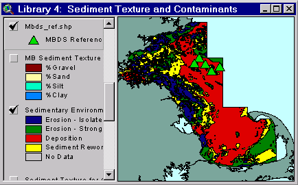
Sample from the ArcView window for Library 4
| Library 4: Sediment Texture and Contaminants |
Return to TABLE OF CONTENTS |
| To view all the coverages described in this Library, open the view titled Library 4 while running the ArcView project (mbay_30.apr or mbay_31.apr) in the mbaygis directory of this CD-ROM. To view summary metadata (file names, descriptions, provider, references) see the table below. To view complete metadata, go to directory "9_biblio" on this CD-ROM and open the file metadata.mdb using Microsoft Access or the file Gismeta.htm using your browser. |
Sample from the ArcView window for Library 4 |
Sediment Texture
Sediment grain size is a basic physical parameter used for environmental, mineral resource, sediment transport, and other assessments. A large dataset has been compiled by the USGS on the grain size of the sediments along the Atlantic continental margin. This database contains data collected by the USGS in this region over the last four decades. The dataset presented here represents the Boston Harbor and Massachusetts Bay portion of the database and contains textural parameters such as % gravel, % sand, % silt, % clay, cumulative Phi sizes, skewness, and kurtosis. The dataset is intended for use by the USGS and other environmental managers in assessing the sedimentary environment within Massachusetts Bay. This information may be useful in comparisons to more recently collected data as well as policy makers for resource management in the region.
The data archive, maintained by the USGS Woods Hole Field Center, contains all of the texture data obtained from samples collected by the USGS since the late 1950s. A version of this dataset was published in 1971 by Hathaway and was released on the WWW in 1994 (http://woodshole.er.usgs.gov/data1/SEDIMENTS/hathaway). The texture samples are processed according to the procedures outlined in Poppe (1985). The data on this CD-ROM include new data in the Massachusetts Bay region collected since 1994, primarily by Bothner and Valentine.
The texture data presented has been checked for errors by batch validation techniques. The data have been verified by checking cumulative phi values as well as other percentage components (gravel, sand, silt, and clay) to assure they add to 100. As with any large data collection, further errors may be identified as the data is applied. Users are encouraged to convey any data errors so they may be corrected in the database.
The data provided in Library 4 are represented as points in Boston Harbor and Massachusetts Bay. Shapefiles are provided that display the location of samples as well as pie diagrams showing the distribution of gravel, sand, silt, and clay at each location. Clicking on an individual point will bring up the information contained within the attribute table such as latitude, longitude, data source, depth, year collected, percent gravel, sand, silt, and clay, cumulative Phi sizes, skewness, kurtosis, and a comments field.
Contaminants in Sediments
Contaminants in Massachusetts Bay have been accumulating in the bottom sediments for many years. Heavy metals, pesticides, petroleum compounds, and nutrients recorded in the sediments originate from a variety of industrial, municipal, and domestic sources. Concentrations of these contaminants vary widely in the Gulf of Maine region and have been individually documented by many researchers. A large dataset has been compiled by the USGS on the contaminant deposition in Gulf of Maine sediments in order to contain and quantify the research conducted in this region over the last 30 years. The dataset presented here represents the Boston Harbor and Massachusetts Bay portion of the database for two elements, copper and zinc. The dataset is intended for use by the USGS and other environmental managers to assess the environmental health of this ecosystem, the transport paths of the contaminants, and the ultimate fate of those contaminants. This information may be useful for comparisons to more recently collected data as well as policy makers for remediation and resource management of the Gulf of Maine.
The database has been compiled through the collaboration and cooperation of state, federal, and local agencies as well as university scientists. These collaborators include: Jackson Estuarine Laboratory at the University of New Hampshire, Bigelow Laboratory of Ocean Sciences, Woods Hole Oceanographic Institution, Department of Environmental Sciences at the University of Massachusetts at Boston, U.S. Army Corps of Engineers-New England District, U.S. Environmental Protection Agency-Region I, National Oceanic and Atmospheric Administration, Massachusetts Water Resources Authority, and the environmental agencies from the states of Massachusetts, New Hampshire, and Maine.
The database as a whole is a compilation of organic, inorganic, and texture data, sample location information, and comments on the data quality for over 7,700 sediment samples in the Gulf of Maine region. The portion presented here represents about 4,000 samples for copper and zinc in the Boston Harbor/Massachusetts Bay region. The data originate from a variety of sources including published scientific studies, unpublished reports from consulting firms, permit files held by the Army Corps of Engineers for proposed construction, and unpublished data from regional scientists. The Contaminated Sediments Database team at the U.S. Geological Survey has edited and validated the enclosed data using maps and plots of the distribution of contaminants in the region to insure the quality of the data. The team is involved in an ongoing effort to include all possible sources of information on sediment quality in the region.
Users interested in contaminated sediments, metals, organics, and pollution in the region may read about the accomplishments of the project to date by checking the website in progress at http://marine.usgs.gov/projects96/mtbrink-cont.txt.html. The data will also be presented as a whole in database and spreadsheet form on another WWW site and a CD-ROM.
The data provided in Library 4 are represented as points in Boston Harbor and Massachusetts Bay. Files are provided that display the location of the samples as well as the associated copper and zinc concentrations. Clicking on an individual point will bring up the information contained contained within the attribute table such as latitude, longitude, original data source, methods used in the analysis, comments on the methods, comments on data quality (in draft form), and available detection limits. The data are displayed based on the potential sediment toxicity to organisms based on correlation’s from a large national sediment database (Long and others, 1996a). The ER-L is the Effects Range-Low predicting less than 10% mortality in organisms exposed to these sediment concentrations. The ER-M is the Effects Range-Medium predicting greater than 50% mortality in exposed organisms.
Coverages provided in Library 4: (Summary metadata for files in the Library 4 view are listed alphabetically in the table below. For complete metadata, go to directory "9_biblio" on this CD-ROM and open the file metadata.mdb using Microsoft Access or the file Gismeta.htm using your browser.)
| File Name | Layer Content | Published reference | E-mail of Contact Person | Agency/Organization |
|---|---|---|---|---|
| Jslinorg.shp | Inorganic chemistry values from JSL sediment samples | wwwnurc@uconnvm.uconn.edu | NOAA/NURC | |
| Jslorgan.shp | Organic chemistry values from JSL sediment samples | wwwnurc@uconnvm.uconn.edu | NOAA/NURC | |
| MB_mets.shp | Copper and Zinc concentrations in surface sediments | Buchholtz ten Brink, M.R. and others, Contaminated sediments database for the Gulf of Maine. U.S. Geological Survey Open-File Report. Web publication and CD-ROM. (in prep.) (see referen.htm for full list of authors) | mtenbrink@usgs.gov, emecray@usgs.gov | USGS |
| MB_text.shp | Surficial sediment texture | Buchholtz ten Brink, M.R. and others, Contaminated sediments database for the Gulf of Maine. U.S. Geological Survey Open-File Report. Web publication and CD-ROM. (in prep.) (see referen.htm for full list of authors) | phastings@usgs.gov | USGS |
| mbds_ref.shp | Mass Bay Disposal Site/Industrial Waste Site Reference Stations | EPA Reported locations, Massachusetts Bay Disposal Site Management Plan | liebman.matt@epamail.epa.gov, thomas.j.fredette@usace.army.mil | USEPA/Region 1 |
| mbdsch2.htm | Sediment quality at reference and regional stations at Mass Bay Disposal Site | |||
| noaa1981.shp | NOAA Sediment Samples | john.lindsay@noaa.gov | NOAA | |
| noaa1982.shp | SAI sediment Samples | john.lindsay@noaa.gov | Science Applications Inc./EPA | |
| Sed_lns.shp | Surficial sediment lines for greater Gulf of Maine | Poppe, L.J., Schlee, J. S., Butman, B., and Lane, C.M., 1989. Map showing distribution of surficial sediment, Gulf of Maine and Georges Bank, Miscellaneous Investigations Series Map, I-1986-A, 1 sheet. | lpoppe@usgs.gov,
wwwnurc@uconnvm.uconn.edu
|
USGS |
| Sed_poly.shp | Surficial sediment polygons for greater Gulf of Maine | Poppe, L.J., Schlee, J. S., Butman, B., and Lane, C.M., 1989. Map showing distribution of surficial sediment, Gulf of Maine and Georges Bank, Miscellaneous Investigations Series Map, I-1986-A, 1 sheet. | lpoppe@usgs.gov,
wwwnurc@uconnvm.uconn.edu
|
USGS |
| sedfindd.shp | Sedimentary Environments Map | Knebel, H.J. and Circe, R.C., 1995; Knebel, H.J., Rendigs, R.R., List, J.H., and Signell, R.P., 1996; Butman, B. and Bothner, M.H., 1998. (see referen.htm for full references) | hknebel@usgs.gov | USGS |
| sedtbl16.shp | Sediment Samples, Area 3 | john.lindsay@noaa.gov | ||
| sedtbl21.shp | Sediment Sample Locations | john.lindsay@noaa.gov | NOAA | |
| sedtbl23.shp | Sediment Sample Locations | john.lindsay@noaa.gov | ||
| USGSsedm.shp | USGS long-term sediment monitoring stations | mbothner@usgs.gov | USGS |
Return to TABLE OF CONTENTS
Continue to LIBRARY 5
[an error occurred while processing this directive]