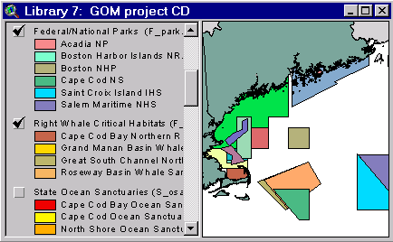
Sample from the ArcView window for Library 7
| Library 7: Web Links and GOM Project CD |
Return to TABLE OF CONTENTS |
| To view all the coverages described in this Library, open the view titled Library 7 while running the ArcView project (mbay_30.apr or mbay_31.apr) in the mbaygis directory of this CD-ROM. To view summary metadata (file names, descriptions, provider, references) see the table below. To view complete metadata, go to directory "9_biblio" on this CD-ROM and open the file metadata.mdb using Microsoft Access or the file Gismeta.htm using your browser. |
Sample from the ArcView window for Library 7 |
This chapter contains a list of Web Sites that contain data and information relevant to Massachusetts Bay, as well as the contents of a previously released CD-ROM (Bauman and others, 1998) containing coverages of the Gulf of Maine.
Selected Websites
http://oracle.er.usgs.gov/gomaine Gulf of Maine Information System
http://vineyard.er.usgs.gov Stellwagen Bank Information System
http://massbay.mit.edu Massachusetts Bay Information Server
http://coast.mit.edu Massachusetts Color Coastal Orthophotos
http://ortho.mit.edu/ MIT digital Orthophotos
http://crusty.er.usgs.gov/ Coastal Ocean Modeling at the USGS
http://crusty.er.usgs.gov/coast/getcoast.html Coast Line extractor
http://water.usgs.gov/lookup/getgislist USGS Water Resources Division, Spatial Data Sets
http://www.epa.gov/enviro/html/pcs/adhoc.html EPA National Pollutant Discharge Elimination System (NPDES) permits
http://www-orca.nos.noaa.gov/projects/gomaine Gulf of Maine Land-Based Pollution Sources Inventory
http://www.mwra.state.ma.us/harbor/html/bhrecov.htm MWRA Boston Harbor Water Quality and Outfall monitoring studies
http://www.nae.usace.army.mil/environm/damos1.htm USACE Disposal Area Monitoring System (DAMOS)
http://www.nurc.uconn.edu Northeast National Undersea Research Center
http://mapfinder.nos.noaa.gov/ NOS imagery and data holdings for coastal photography, nautical charts, historical maps, coastal survey maps, environmental sensitivity index maps, hydrographic survey outlines, water level stations, estuarine bathymetry, and geodetic control points.
http://chartmaker.ncd.noaa.gov/ocs/text/MAP-COLL.htm NOAA's digital collection of historical maps and charts (click on Image Catalog, then Sort by State, Massachusetts)
Gulf of Maine Project
Data from the previously released CD-ROM (Bauman and others, 1998) has been incorporated into Chapter 7 and contains the Database of Existing Coastal & Marine Protected Areas, Conservation Zones, and Restricted Fishing Areas in the Gulf of Maine. This database is in ArcView shape file and Excel formats. Included in this chapter are coastline shape files, map composition files, metadata file and a summary report (see links below).
MACPA.XLS - Excel spreadsheet
METADATA.DOC - describes the GIS database
REPORT.DOC - report on the methods used to create the database and conclusions/recommendations
SITES.XLS- list of the sites included in the database
Files provided in Library 7: (Summary metadata for files in the Library7 view are listed alphabetically in the table below. For complete metadata, go to the directory "9_biblio" on this CD-ROM and open the file metadata.mdb using Microsoft Access or the file Gismeta.htm using your browser.)
| File Name | Layer Content | Published reference | E-mail of Contact Person | Agency/Organization |
|---|---|---|---|---|
| ca_ngo.shp | Canadian Non-governmental sites | Baumann, Carol, Sam Brody, Derek Fenton, and Betsy Nicholson, 1998, A GIS Database of Existing Coastal and Marine Protected Areas, Conservation Zones, and Restricted Fishing Areas in the Gulf of Maine. | cbaumann@cenmarine.com | Center for Marine Conservation, Gulf of Maine Protected Areas Project, Dept of Fisheries and Oceans Canada, Woods Hole Oceanographic Institution |
| f_crthab.shp | Right Whale Critical Habitats | Baumann, Carol, Sam Brody, Derek Fenton, and Betsy Nicholson, 1998, A GIS Database of Existing Coastal and Marine Protected Areas, Conservation Zones, and Restricted Fishing Areas in the Gulf of Maine. | cbaumann@cenmarine.com | Center for Marine Conservation, Gulf of Maine Protected Areas Project, Dept of Fisheries and Oceans Canada, Woods Hole Oceanographic Institution |
| f_cws_pt.shp | Canada Wildlife Service sites: Migratory Bird Sanctuary, National Wildlife Areas | Baumann, Carol, Sam Brody, Derek Fenton, and Betsy Nicholson, 1998, A GIS Database of Existing Coastal and Marine Protected Areas, Conservation Zones, and Restricted Fishing Areas in the Gulf of Maine. | cbaumann@cenmarine.com | Center for Marine Conservation, Gulf of Maine Protected Areas Project, Dept of Fisheries and Oceans Canada, Woods Hole Oceanographic Institution |
| f_fish.shp | Federal fishing closures: National Marine Fisheries Service, Department of Fisheries and Oceans | Baumann, Carol, Sam Brody, Derek Fenton, and Betsy Nicholson, 1998, A GIS Database of Existing Coastal and Marine Protected Areas, Conservation Zones, and Restricted Fishing Areas in the Gulf of Maine. | cbaumann@cenmarine.com | Center for Marine Conservation, Gulf of Maine Protected Areas Project, Dept of Fisheries and Oceans Canada, Woods Hole Oceanographic Institution |
| f_nerr.shp | National Estuarine Research Reserves (polygons) | Baumann, Carol, Sam Brody, Derek Fenton, and Betsy Nicholson, 1998, A GIS Database of Existing Coastal and Marine Protected Areas, Conservation Zones, and Restricted Fishing Areas in the Gulf of Maine. | cbaumann@cenmarine.com | Center for Marine Conservation, Gulf of Maine Protected Areas Project, Dept of Fisheries and Oceans Canada, Woods Hole Oceanographic Institution |
| f_nerrpt.shp | National Estuarine Research Reserves (points) | Baumann, Carol, Sam Brody, Derek Fenton, and Betsy Nicholson, 1998, A GIS Database of Existing Coastal and Marine Protected Areas, Conservation Zones, and Restricted Fishing Areas in the Gulf of Maine. | cbaumann@cenmarine.com | Center for Marine Conservation, Gulf of Maine Protected Areas Project, Dept of Fisheries and Oceans Canada, Woods Hole Oceanographic Institution |
| f_nms.shp | National Marine Sanctuaries (Stellwagen Bank) | Baumann, Carol, Sam Brody, Derek Fenton, and Betsy Nicholson, 1998, A GIS Database of Existing Coastal and Marine Protected Areas, Conservation Zones, and Restricted Fishing Areas in the Gulf of Maine. | cbaumann@cenmarine.com | Center for Marine Conservation, Gulf of Maine Protected Areas Project, Dept of Fisheries and Oceans Canada, Woods Hole Oceanographic Institution |
| f_nwr.shp | National Wildlife Refuges | Baumann, Carol, Sam Brody, Derek Fenton, and Betsy Nicholson, 1998, A GIS Database of Existing Coastal and Marine Protected Areas, Conservation Zones, and Restricted Fishing Areas in the Gulf of Maine. | cbaumann@cenmarine.com | Center for Marine Conservation, Gulf of Maine Protected Areas Project, Dept of Fisheries and Oceans Canada, Woods Hole Oceanographic Institution |
| f_park.shp | Federal/National Parks (polygons) | Baumann, Carol, Sam Brody, Derek Fenton, and Betsy Nicholson, 1998, A GIS Database of Existing Coastal and Marine Protected Areas, Conservation Zones, and Restricted Fishing Areas in the Gulf of Maine. | cbaumann@cenmarine.com | Center for Marine Conservation, Gulf of Maine Protected Areas Project, Dept of Fisheries and Oceans Canada, Woods Hole Oceanographic Institution |
| f_parkpt.shp | Federal/National Parks (points) | Baumann, Carol, Sam Brody, Derek Fenton, and Betsy Nicholson, 1998, A GIS Database of Existing Coastal and Marine Protected Areas, Conservation Zones, and Restricted Fishing Areas in the Gulf of Maine. | cbaumann@cenmarine.com | Center for Marine Conservation, Gulf of Maine Protected Areas Project, Dept of Fisheries and Oceans Canada, Woods Hole Oceanographic Institution |
| MACPA.XLS | Excel spreadsheet of boundaries | Baumann, Carol, Sam Brody, Derek Fenton, and Betsy Nicholson, 1998, A GIS Database of Existing Coastal and Marine Protected Areas, Conservation Zones, and Restricted Fishing Areas in the Gulf of Maine. | cbaumann@cenmarine.com | Center for Marine Conservation, Gulf of Maine Protected Areas Project, Dept of Fisheries and Oceans Canada, Woods Hole Oceanographic Institution |
| me_eshab.shp | Maine’s State Essential Habitat for Endangered Species | Baumann, Carol, Sam Brody, Derek Fenton, and Betsy Nicholson, 1998, A GIS Database of Existing Coastal and Marine Protected Areas, Conservation Zones, and Restricted Fishing Areas in the Gulf of Maine. | cbaumann@cenmarine.com | Center for Marine Conservation, Gulf of Maine Protected Areas Project, Dept of Fisheries and Oceans Canada, Woods Hole Oceanographic Institution |
| METADATA.DOC | Description of Database of Existing Coastal and Marine Protected Areas CD-ROM | Baumann, Carol, Sam Brody, Derek Fenton, and Betsy Nicholson, 1998, A GIS Database of Existing Coastal and Marine Protected Areas, Conservation Zones, and Restricted Fishing Areas in the Gulf of Maine. | cbaumann@cenmarine.com | Center for Marine Conservation, Gulf of Maine Protected Areas Project, Dept of Fisheries and Oceans Canada, Woods Hole Oceanographic Institution |
| p_eshab.shp | Eastern Habitat Joint Venture sites (Canada) | Baumann, Carol, Sam Brody, Derek Fenton, and Betsy Nicholson, 1998, A GIS Database of Existing Coastal and Marine Protected Areas, Conservation Zones, and Restricted Fishing Areas in the Gulf of Maine. | cbaumann@cenmarine.com | Center for Marine Conservation, Gulf of Maine Protected Areas Project, Dept of Fisheries and Oceans Canada, Woods Hole Oceanographic Institution |
| REPORT.DOC | Methods used to create database and conclusions/recommendations | Baumann, Carol, Sam Brody, Derek Fenton, and Betsy Nicholson, 1998, A GIS Database of Existing Coastal and Marine Protected Areas, Conservation Zones, and Restricted Fishing Areas in the Gulf of Maine. | cbaumann@cenmarine.com | Center for Marine Conservation, Gulf of Maine Protected Areas Project, Dept of Fisheries and Oceans Canada, Woods Hole Oceanographic Institution |
| s_acec.shp | State Areas of Critical Environmental Concern | Baumann, Carol, Sam Brody, Derek Fenton, and Betsy Nicholson, 1998, A GIS Database of Existing Coastal and Marine Protected Areas, Conservation Zones, and Restricted Fishing Areas in the Gulf of Maine. | cbaumann@cenmarine.com | Center for Marine Conservation, Gulf of Maine Protected Areas Project, Dept of Fisheries and Oceans Canada, Woods Hole Oceanographic Institution |
| s_comp.shp | State Complimentary Harbor Porpoise Closures | Baumann, Carol, Sam Brody, Derek Fenton, and Betsy Nicholson, 1998, A GIS Database of Existing Coastal and Marine Protected Areas, Conservation Zones, and Restricted Fishing Areas in the Gulf of Maine. | cbaumann@cenmarine.com | Center for Marine Conservation, Gulf of Maine Protected Areas Project, Dept of Fisheries and Oceans Canada, Woods Hole Oceanographic Institution |
| s_fish.shp | State fishing restrictions: mobile and fixed gear regulations (polygons) | Baumann, Carol, Sam Brody, Derek Fenton, and Betsy Nicholson, 1998, A GIS Database of Existing Coastal and Marine Protected Areas, Conservation Zones, and Restricted Fishing Areas in the Gulf of Maine. | cbaumann@cenmarine.com | Center for Marine Conservation, Gulf of Maine Protected Areas Project, Dept of Fisheries and Oceans Canada, Woods Hole Oceanographic Institution |
| s_fishpt.shp | State fishing restrictions: mobile and fixed gear regulations (points) | Baumann, Carol, Sam Brody, Derek Fenton, and Betsy Nicholson, 1998, A GIS Database of Existing Coastal and Marine Protected Areas, Conservation Zones, and Restricted Fishing Areas in the Gulf of Maine. | cbaumann@cenmarine.com | Center for Marine Conservation, Gulf of Maine Protected Areas Project, Dept of Fisheries and Oceans Canada, Woods Hole Oceanographic Institution |
| s_hist.shp | State Historic Sites (polygons) | Baumann, Carol, Sam Brody, Derek Fenton, and Betsy Nicholson, 1998, A GIS Database of Existing Coastal and Marine Protected Areas, Conservation Zones, and Restricted Fishing Areas in the Gulf of Maine. | cbaumann@cenmarine.com | Center for Marine Conservation, Gulf of Maine Protected Areas Project, Dept of Fisheries and Oceans Canada, Woods Hole Oceanographic Institution |
| s_histpt.shp | State Historic Sites (points) | Baumann, Carol, Sam Brody, Derek Fenton, and Betsy Nicholson, 1998, A GIS Database of Existing Coastal and Marine Protected Areas, Conservation Zones, and Restricted Fishing Areas in the Gulf of Maine. | cbaumann@cenmarine.com | Center for Marine Conservation, Gulf of Maine Protected Areas Project, Dept of Fisheries and Oceans Canada, Woods Hole Oceanographic Institution |
| s_mca.shp | State Marine Conservation Areas | Baumann, Carol, Sam Brody, Derek Fenton, and Betsy Nicholson, 1998, A GIS Database of Existing Coastal and Marine Protected Areas, Conservation Zones, and Restricted Fishing Areas in the Gulf of Maine. | cbaumann@cenmarine.com | Center for Marine Conservation, Gulf of Maine Protected Areas Project, Dept of Fisheries and Oceans Canada, Woods Hole Oceanographic Institution |
| s_osanc.shp | State Ocean Sanctuaries | Baumann, Carol, Sam Brody, Derek Fenton, and Betsy Nicholson, 1998, A GIS Database of Existing Coastal and Marine Protected Areas, Conservation Zones, and Restricted Fishing Areas in the Gulf of Maine. | cbaumann@cenmarine.com | Center for Marine Conservation, Gulf of Maine Protected Areas Project, Dept of Fisheries and Oceans Canada, Woods Hole Oceanographic Institution |
| s_prl.shp | State Public Reserved Lands | Baumann, Carol, Sam Brody, Derek Fenton, and Betsy Nicholson, 1998, A GIS Database of Existing Coastal and Marine Protected Areas, Conservation Zones, and Restricted Fishing Areas in the Gulf of Maine. | cbaumann@cenmarine.com | Center for Marine Conservation, Gulf of Maine Protected Areas Project, Dept of Fisheries and Oceans Canada, Woods Hole Oceanographic Institution |
| s_wsanc.shp | State Wildlife Sanctuaries | Baumann, Carol, Sam Brody, Derek Fenton, and Betsy Nicholson, 1998, A GIS Database of Existing Coastal and Marine Protected Areas, Conservation Zones, and Restricted Fishing Areas in the Gulf of Maine. | cbaumann@cenmarine.com | Center for Marine Conservation, Gulf of Maine Protected Areas Project, Dept of Fisheries and Oceans Canada, Woods Hole Oceanographic Institution |
| SITES.XLS | List of sites included in the database | Baumann, Carol, Sam Brody, Derek Fenton, and Betsy Nicholson, 1998, A GIS Database of Existing Coastal and Marine Protected Areas, Conservation Zones, and Restricted Fishing Areas in the Gulf of Maine. | cbaumann@cenmarine.com | Center for Marine Conservation, Gulf of Maine Protected Areas Project, Dept of Fisheries and Oceans Canada, Woods Hole Oceanographic Institution |
| sp_park.shp | State/Provincial Parks: parks, forests, reservations, beaches, marinas, piers (polygons) | Baumann, Carol, Sam Brody, Derek Fenton, and Betsy Nicholson, 1998, A GIS Database of Existing Coastal and Marine Protected Areas, Conservation Zones, and Restricted Fishing Areas in the Gulf of Maine. | cbaumann@cenmarine.com | Center for Marine Conservation, Gulf of Maine Protected Areas Project, Dept of Fisheries and Oceans Canada, Woods Hole Oceanographic Institution |
| sp_prkpt.shp | State/Provincial Parks: parks, forests, reservations, beaches, marinas, piers (points) | Baumann, Carol, Sam Brody, Derek Fenton, and Betsy Nicholson, 1998, A GIS Database of Existing Coastal and Marine Protected Areas, Conservation Zones, and Restricted Fishing Areas in the Gulf of Maine. | cbaumann@cenmarine.com | Center for Marine Conservation, Gulf of Maine Protected Areas Project, Dept of Fisheries and Oceans Canada, Woods Hole Oceanographic Institution |
| sp_wma.shp | State/Provincial Wildlife Management Areas (polygons) | Baumann, Carol, Sam Brody, Derek Fenton, and Betsy Nicholson, 1998, A GIS Database of Existing Coastal and Marine Protected Areas, Conservation Zones, and Restricted Fishing Areas in the Gulf of Maine. | cbaumann@cenmarine.com | Center for Marine Conservation, Gulf of Maine Protected Areas Project, Dept of Fisheries and Oceans Canada, Woods Hole Oceanographic Institution |
| sp_wmapt.shp | State/Provincial Wildlife Management Areas (points) | Baumann, Carol, Sam Brody, Derek Fenton, and Betsy Nicholson, 1998, A GIS Database of Existing Coastal and Marine Protected Areas, Conservation Zones, and Restricted Fishing Areas in the Gulf of Maine. | cbaumann@cenmarine.com | Center for Marine Conservation, Gulf of Maine Protected Areas Project, Dept of Fisheries and Oceans Canada, Woods Hole Oceanographic Institution |
Return to TABLE OF CONTENTS
Continue to LIBRARY 8
[an error occurred while processing this directive]