Open-File Report 00-032
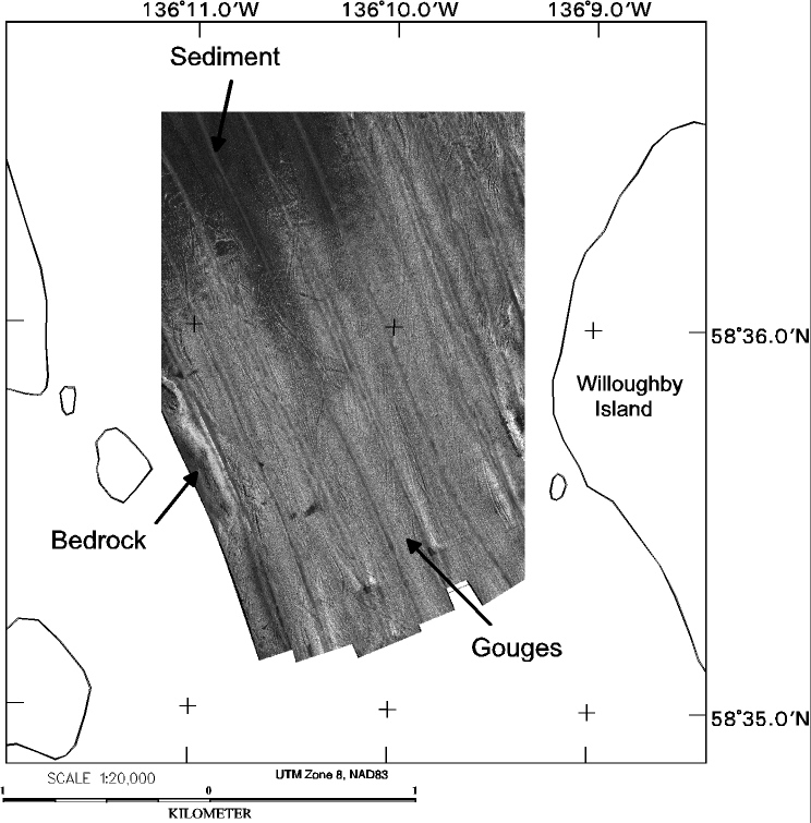
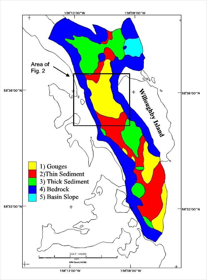
Analysis of Side Scan ImageryIn a future report, we will characterize the benthic habitat using a combination of the side-scan data, the profiling data, onshore geologic mapping by Brew et al. (1978), and previous marine geology work (e.g. Carlson et al., 1977; Cai et al., 1997). Final interpretations will be in the form of georeferenced habitat polygons which will be combined with the existing Geographic Information System (GIS) database (Geiselman et al., 1997). Our interpretation of the geophysical data will be based on the experience garnered in studying similar acoustic data from Glacier Bay and the Gulf of Alaska (e.g. Carlson et al., 1992, Carlson et al., 1980). We are using a variety of techniques (scuba, delta submersible, rebreathers, drop camera) to visually confirm our interpretation of the geophysical data. We plan to test the predictive value of the interpretation by conducting fish population studies in the areas where the geophysical data interpretations exist. We present a preliminary analysis of the sidescan image collected to the west of Willoughby Island (see above). Figure 2 (160K) shows a portion of the sidescan mosaic produced from the Whidbey passage data set. The criss-crossing pattern of grooves seen in the southern portion of the sidescan image is produced in coarse sediment by the passage of large icebergs similar to the area east of Strawberry Island (Cochrane et al., 1998). The earliest period when large icebergs would have calved up stream of this area is when the glacier terminus was in the area between 1794 and 1845 (American Geographical Society, 1966). Sediment gouging could have occurred in more recent times as icebergs calving further up stream passed Willoughby Island on their way south. A preliminary interpretation of the sidescan data is shown in figure 3 (189K). Using the habitat characterization scheme of Greene et al. (1995), this habitat would be described as Intermediate shelf, gouged gravel and boulder, flat bottom, with probable winnowing by tidal currents. Based on geologic mapping of Brew et al. (1978), we know that bedrock (type 4, figure 3) in the area is Silurian/Devonian carbonate rock. Types 2 and 3 (figure 3) are differentiated on the basis of thickness of recent sediment covering the glacially modified seafloor. The Basin Slope habitat figure 3 (189K) is an area of steeply sloping seafloor at the western edge of the deeper bay waters. Analysis of Halibut usage of this habitat is underway (Carlson et al., in press). |
|
|
For more information, contact the PCMSC team.
This report is preliminary and has not been reviewed for conformity with U.S. Geological Survey editorial standards or with the North American Stratigraphic Code. Use of trade, product, or firm names in this report is for descriptive purposes only and does not imply endorsement by the U.S. Government. Any use of trade, product, or firm names is for descriptive purposes only and does not imply endorsement by the U.S. Government. Suggested citation: U.S. Department of the Interior U.S. Geological Survey |

![]() U.S. Department of the Interior |
U.S. Geological Survey
U.S. Department of the Interior |
U.S. Geological Survey
URL: http://pubsdata.usgs.gov/pubs/of/2000/0032/analysis.html
Page Contact Information: GS Pubs Web Contact
Page Last Modified: Wednesday, 07-Dec-2016 18:16:29 EST
