
Digital Mapping Techniques '00 -- Workshop Proceedings
U.S. Geological Survey Open-File Report 00-325
Illinois State Geological Survey Web-Based Resources:
The Illinois Natural Resources Geospatial Data Clearinghouse and the ISGS Internal GIS Resources Web
By Sheena K. Beaverson and Robert J. Krumm
Illinois State Geological Survey
615 East Peabody Drive
Champaign, IL 61820
Telephone: (217) 244-9306
Fax: (217) 333-2830
e-mail: beavrsn@isgs.uiuc.edu
INTRODUCTION
The Illinois State Geological Survey (ISGS) in Champaign, IL currently hosts three major web-based information resources. These include the ISGS's main public web site (http://www.isgs.uiuc.edu/), the Illinois Natural Resources Geospatial Data Clearinghouse (http://www.isgs.uiuc.edu/nsdihome/), and the ISGS Staff Only intranet. This paper will focus on two ISGS web-based activities maintained and developed by the ISGS Geospatial Analysis and Modeling Section (GAMS) staff. These include the Clearinghouse project, and a sub-section of the Staff-Only intranet identified as the Internal GIS Resources Web.
CLEARINGHOUSE BACKGROUND
Overview
The Illinois Natural Resources Geospatial Data Clearinghouse serves as a gateway to Geographic Information Systems (GIS) data and imagery for Illinois. The project is a multi-agency effort by the Illinois Department of Natural Resources (DNR) Scientific Survey divisions and is associated with the Federal Geographic Data Committee's (FGDC) National Spatial Data Infrastructure (NSDI) clearinghouse. DNR project participants include the ISGS, Illinois Natural History Survey, Illinois State Water Survey, Illinois Waste Management and Research Center, Illinois State Museum, Office of Mines and Minerals, and Office of Realty and Environmental Planning (OREP). Available county and statewide data sets and documentation (metadata) include: geology, water resources, nature preserves, wildlife areas, environment, land cover, Digital Raster Graphic (DRG) files, surface elevation, Public Land Survey, political boundaries, roads, census information, and much more (Figure 1). Other features include a metadata generation tool, information about upcoming metadata workshops, a hotlist of other on-line DNR GIS data-related features, and a listing of DNR's aerial photography holdings.
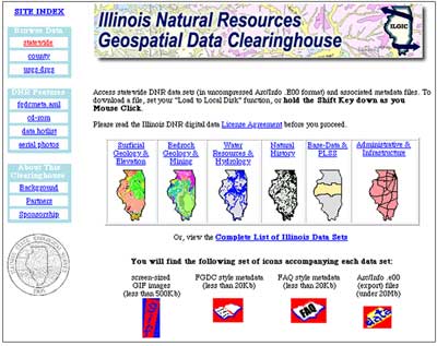
Figure 1. Illinois Natural Resources Geospatial Data Clearinghouse statewide data browse page.
Phase 1: Illinois FGDC Clearinghouse Node
The clearinghouse was brought on-line on July 1, 1997 and currently serves about 1,800 downloadable GIS data sets in ArcInfo export file format (Environmental Systems Research Institute, Inc), described by over 130 complete metadata documents (Nelson et al., 1998a, Nelson et al., 1998b). An additional 100 partial metadata files represent searchable entries from our working list. Data and metadata are accessible through keyword search functions and straightforward browse pages. The browse pages for statewide and county data are augmented with short abstracts, metadata, and GIF images that give a visual snapshot of each data layer. Users can conduct keyword searches of the metadata database either locally at the Illinois Clearinghouse or remotely from the national NSDI gateway (Nelson et al., 1998a, Nelson et al., 1998b).
Phase 2: United States Geological Survey (USGS) Digital Raster Graphic (DRG) Files for Illinois and FAQ-Style Metadata Available On-line
In April, 1999, DRG images of all USGS topographic quadrangle maps for Illinois were made available in a variety of projections and at the following scales: 1:250,000, 1:100,000, and 1:24,000 (Beaverson, 1999). DRG files are georeferenced images produced by scanning USGS topographic maps. This widely-used and recognized map format provides large and intermediate-scale, base map coverage essential for many mapping projects. These files can be selected via map indexes, by name, or by USGS index number, and are available in georeferenced TIFF format.
In early 2000, clearinghouse administrators began including a new metadata format in the browse areas of the web site. This format, generated with mp (Metadata Parser) (Schweitzer, 1999a), expresses metadata elements as answers to standard questions, and is casually referred to as FAQ-Style Metadata (Schweitzer, 1999b). Feedback from ISGS staff indicates that this easy-to-navigate format is a welcome addition to existing catalog options.
Web Statistics
The Clearinghouse project has been used extensively almost from the moment it went on-line. From July 1, 1997 to January 1, 2000, a period of 2.5 years, the site has had 1,453,044 hits by 90,478 individual external users, yielding an average 3,015 users per month. Over 142,100 data sets (roughly 66.5 gigabytes of data) were downloaded. In the year that the DRG files have been available free for download, 13,556 files have been downloaded, equaling 34.3 gigabytes of distributed data. From April 1 to September 31, 1999, an average of 675 DRG files were downloaded per month. This amount more than doubled, to 1,582 files per month in the next six months. This activity represents new data distribution, and these values exclude in-house access by ISGS staff. The ISGS uses WebTrends Enterprise Suite software to track and report Internet statistics (WebTrends Corporation). Although Internet statistics are somewhat uncertain, the numbers indicated herein suggest that the Illinois Natural Resources Geospatial Data Clearinghouse has received a great deal of attention and is providing convenient data access for the GIS community in Illinois.
ISGS INTERNAL GIS RESOURCES WEB
The ISGS Internal GIS Resources Web is an intranet resource providing information for ArcInfo- and ArcView-based GIS operations and web-based Oracle (Oracle Corporation) database interfaces. A detailed site index serves as the front page (Figure 2). Content has been written by members of the ISGS Geospatial Analysis and Modeling Section (GAMS) over the past two and a half years. The "Resources Web" provides staff with a common area to access a collection of Hyper Text Markup Language (HTML) documents in a password-protected area. The information can be accessed by any ISGS staff member from any computer connected to the Internet. New information is added monthly. The web pages present detailed information related to a wide variety of topics, including:
- ISGS database holdings, database design and maintenance,
- ISGS Oracle Database tables
- metadata creation tools and procedures,
- Clearinghouse upkeep and web statistics,
- plotting at the ISGS (user guides and administrative duties),
- GIS Educational Outreach class materials,
- n-house Atools and ArcView Projects,
- cartographic resources and map templates,
- routine GIS technical procedures.
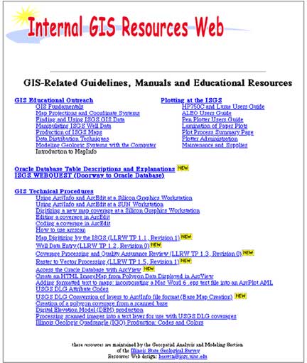
Figure 2. The ISGS GIS Resources Web main page (lower portion).
The ISGS has very limited intranet staff support and no formal intranet development policies. As a result, ISGS Staff-Only interfaces suffer from common intranet maladies, such as authoring bottlenecks, a lack of support from a formal resource center, non-standardized design, or a more simplified design as compared to funded Internet sites, and static content (Gantz, 2000; Nielson, 1999). Staff-Only web page design updates are sporadic and the link to the GIS Resources Web is somewhat difficult to find. As a result, individuals from other sections of the Survey who have questions typically contact a GIS-savvy staff member initially, rather than referring to the on-line reference materials. Nevertheless, members of our section save time and repetitive effort by guiding colleagues to the relevant on-line support materials. In the past year we have greatly expanded the content and begun to apply web usability principles. The Resources Web is gaining attention and positive feedback from our fellow ISGS employees.
CONTINUING EFFORTS
Phase 3: Illinois Digital Orthophoto Quadrangle (DOQ) Files Available On-line
In 1999, state and federal agencies with interests in Illinois entered into a joint funding agreement with the USGS to purchase the full set of Digital Orthophoto quarter Quadrangles (DOQs) for Illinois. DOQs are digital map layers made from aerial photographs that have been registered to map coordinates. Created from 1998/99 photography, these map coverages will be the most up-to-date, large-scale geographic base data available for Illinois. DOQs are well suited for many mapping projects, digital or otherwise. Over the next two years, the State of Illinois will receive one set of these data. External funding is being pursued by the ISGS to support the processing necessary to archive and distribute the 4,135 files. The ISGS plans to distribute compressed versions of the 1998/99 DOQ data files on-line, free for download, at the Illinois Natural Resources Geospatial Data Clearinghouse. The uncompressed data will be offered for sale on CD-ROMs.
We believe that access to the DOQ files will enable GIS and remote sensing professionals to more readily develop projects that foster sustainable use of natural resources. The DOQs will be a vital information resource to address the Illinois' changing land use demands. Thus, the application of DOQs to natural resource protection, mapping, and monitoring will likely yield significant economic impacts.
Addressing Web Usability Issues
Future revisions of the Geospatial Data Clearinghouse and the Internal GIS Resources Web will need to improve the ability of the user to quickly and intuitively access information. The book Designing Web Usability (Nielson, 1999) outlines and illustrates web design elements which improve web site usability. The following observations result from applying the principles put forward in that book. For the Clearinghouse, improvements in the content initially displayed to the user will be a high priority. Possible refinements include returning FAQ-style metadata as search results, simplifying introductory statements, review and revision of all metadata and Arc/Info data holdings, and migration away from a frames-based layout to individual web pages with Server Side Includes (SSI). SSI allow a web designer to insert repetitive information, like logos or navigation bars, from one master file into multiple HTML documents. For a brief description on implementing SSI, refer to the NCSA HTTPd Tutorials web site (http://hoohoo.ncsa.uiuc.edu/docs/tutorials/ )or this support page from a web service provider
(http://www.infodial.net/support/ssi/index.htm).
The Resources Web would benefit from targeted content expansions, a simplified front page interface, and a comprehensive review and update of older documents. A concentrated effort to increase development of the ISGS intranet would also result in enhanced reliance on sub-site reference materials. In the meantime, we will continue to make content additions when possible and strive to keep the navigational design as straightforward as possible.
ACKNOWLEDGMENTS
The following ISGS staff members made significant contributions to recent Clearinghouse expansions: Dan Nelson, Galen Arnold and Sally Denhart. Funding has been provided by the USGS via the FGDC Competitive Cooperative Agreements Program and the Illinois Council for Agricultural Research (C-FAR) through the Strategic Research Initiative in Information Systems and Technology. Seed funding for further clearinghouse expansion has been secured from the Illinois OREP,
C-FAR and an Online Development grant from the University of Illinois. Additional support for all phases of development has been provided by the ISGS. Contributors and editors of the GIS Resources Web files include Curt Abert, Galen Arnold, Sheena Beaverson, James Hester, Alison Lecouris, Rob Krumm, Chris McGarry, Renee Nagy, Dan Nelson, Matt Riggs, and Barb Stiff. The authors thank Jon Goodwin, David Grimley and Matthew Riggs of the ISGS and David Soller of the USGS for their editorial review of this manuscript.
REFERENCES
Beaverson, S.K., 1999, Final Report for the 1999 C-FAR Water Quality and Natural Resources Strategic Research Initiative in Information Systems and Technology Project Entitled: Map Illinois - Illinois Natural Resources Geospatial Data Clearinghouse: http://www.isgs.uiuc.edu/nsdihome/webdocs/phase2.htm.
Gantz, J., 2000, Controlling the Coming Chaos of Intranets: Computerworld, March 6, 2000 Issue,
http://www.computerworld.com/.
Nielsen, J., 1999, Designing Web Usability: The Practice of Simplicity: New Riders Publishing, 432 p.
Nelson, D.O., Beaverson, S.K., and Krumm, R.J., 1998a, Final Project Report for the 1996 Federal Geographic Data Committee Competitive Cooperative Agreements Program Project Entitled Illinois Natural Resources, A Prototype National Geospatial Data Clearinghouse Node: http://www.isgs.uiuic.edu/nsdihome/webdocs/capfinalrpt.html.
Nelson, D.O., Beaverson, S.K., and Krumm, R.J., 1998b, The Illinois Natural Resources Geospatial Data Clearinghouse, A Prototype NSDI Clearinghouse Node in Illinois, in D.R. Soller, ed., Digital Mapping Techniques '98 -- Workshop Proceedings: U.S. Geological Survey Open-File Report 98-487, p. 91-95, https://pubs.usgs.gov/openfile/of98-487/nelson.html.
Schweitzer, P.N., 1999a, Tools for Creation of Formal Metadata - mp (version 2.5.2), a compiler for formal Metadata: U.S. Geological Survey, Reston, Virginia, http://geology.usgs.gov/tools/metadata/.
Schweitzer, P.N., 1999b, Plain-Language Resources for Metadata Creators and Reviewers, in D.R. Soller, ed., Digital Mapping Techniques '99 -- Workshop Proceedings: U.S. Geological Survey Open-File Report 99-386, p. 43-45, https://pubs.usgs.gov/openfile/of99-386/schweitzer.html.
U.S.Department of the Interior, U.S. Geological Survey
<https://pubs.usgs.gov/openfile/of00-325/beaverson.html>
Maintained by Dave Soller
Last updated 11.01.00