
Digital Mapping Techniques '00 -- Workshop Proceedings
U.S. Geological Survey Open-File Report 00-325
The Central Publications Group
Map-On-Demand (MOD) System
By J. D. Hoffman
U.S. Geological Survey
Box 25046, MS 902
Denver Federal Center
Denver, CO 80225-0046
Telephone: (303) 236-2490
Fax: (303) 236-6287
e-mail: jhoffman@usgs.gov
INTRODUCTION
The U.S. Geological Survey (USGS) uses both conventional and digital methods for the compilation of geologic and other thematic maps. Increasing emphasis is being placed on totally digital compilation. The production system used by the Central Publications Group of the USGS was described by Lane and others (1999). Such maps have been and are continuing to be released via one or more of three methods: (1) printing maps on paper at a printing plant, (2) releasing maps online in PDF format, and (3) using the Maps-On-Demand (MOD) system. This paper discusses the third method.
Low-demand maps cost about as much to print as higher-demand maps. Because a large portion of USGS geologic maps are in the former category, conventional printing of such maps is often uneconomical. The Maps-On-Demand (MOD) system is designed to remedy this and other problems.
MOD GOALS
As the cost of printing via conventional press technology has become less affordable, the USGS MOD system has become more appealing. The system has seven distinct goals:
- Print high-quality products. MOD maps are close to offset press print quality.
- Allow for low-demand maps. The MOD system maintains no inventory.
- Reduce production cost. The cost is about 25% of conventional offset press printing.
- Decrease production delays. All production is "in-house" and is entirely digital.
- Reproduce out-of-print maps. Maps are scanned and re-released via the MOD system.
- Archive maps. Files are stored on CDR media.
- Ensure that maps are never "out-of-print." The "inventory" is stored digitally.
ADVANTAGES AND DISADVANTAGES
The lower production cost results in higher customer costs. The price of a MOD map is $20 per sheet. In contrast, the cost for printed thematic maps is now $7 per sheet. We trust that customers will consider the price of a MOD product a fair trade for fast production or availability of an otherwise out-or-print map. In many cases, due to economic reasons, the MOD system allows for publishing maps that otherwise would not be published.
Because printing a map on a high-resolution plotter is quite slow, the MOD system has a low production capacity. Maps take typically from 15 to 30 minutes to plot.
MOD SYSTEM TOPOLOGY
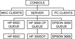
Figure 1. MOD system topology.
|
The MOD system is powered by a Powerpage PostScript Raster Image Processor (RIP) bundled with the Postershop large-format printing system. The installation employs a client-server relationship (figure 1), with the server hosting both Apple Macintosh and Microsoft Windows-based PC's. The server software runs on a 400 Mhz dual-processor Windows NT4-based server with 512 MB RAM and 27 GB of hard disk space. The RIP server software drives a Hewlett-Packard (HP) 3000CP plotter, an HP 650C plotter, and an Epson 3000 printer. Both Macintosh and Windows-based PC's are transparently served using easily configured clients.
SIGNIFICANT MOD FEATURES
The Postershop RIP server converts PostScipt and seven bit-mapped file types to plotter-native files. File rendition is extremely accurate. The maximum resolution of the HP 3000CP is 600 dpi. The maximum resolution of the Epson 3000 printer is 1,440 by 720 dpi. The HP 650C plotter, having a resolution of 300 dpi, is used for rough drafts. Input files size is for all intents and purposes unlimited; the system has successfully RIPed files approaching 1 GB.
A Postershop client installed on a Windows NT workstation is used for functions such as previewing an image to be RIPed, color adjustment of image files, creating and editing color profiles, tiling, and creating CD-ROM's of RIPed files for plotting and distribution.
MOD PRODUCTS
Geologic Investigation Maps (I-maps). I-maps present data and interpretations of lasting interest for scientific and technical audiences. MOD products are not generally released within this series; a few I-maps maps have been released as MOD I-maps.
Miscellaneous Field Studies Maps (MF-maps). MF-maps have the same content, quality, and review standards as I-maps but with a more limited scope, audience, or expected longevity. Also, urgency of release or lack of funds often require releasing a map in the MF series.
Open-File Reports (OFR). OFR maps are generally unedited preliminary maps intended to be superseded by formal publications.
Scans of out-of-print maps of any series.
DISTRIBUTION
Announcement of new MOD products is made through "New Publications of the U.S. Geological Survey" (https://pubs.usgs.gov/publications/) and the MOD web site at http://rmmcweb.cr.usgs.gov/public/mod/. This web site contains information about maps available though the MOD system and an order form. MOD maps are printed on an HP 3000CP plotter at 600 dpi resolution using UV-resistant inks and heavy-weight coated paper.
Other pertinent U.S. Geological Survey geologic map web sites are: http://greenwood.cr.usgs.gov/,
http://geology.er.usgs.gov/, and http://geology.wr.usgs.gov/.
REFERENCE
Lane, D. E., Donatich, Alex, Brunstein, F. C., and Shock, Nancy, 1999, Digital geologic map production and database development in the Central Publications Group of the Geologic Division, U.S. Geological Survey, in D. R. Soller, ed., Digital Mapping Techniques '99--Workshop Proceedings: U.S. Geological Survey Open-File Report 99-386, p. 11-15, https://pubs.usgs.gov/openfile/of99-386/lane.html.
U.S.Department of the Interior, U.S. Geological Survey
<https://pubs.usgs.gov/openfile/of00-325/hoffman.html>
Maintained by Dave Soller
Last updated 11.01.00