
Digital Mapping Techniques '00 -- Workshop Proceedings
U.S. Geological Survey Open-File Report 00-325
Digital Geologic Map of Utah: A Method of Presentation
By Kent D. Brown1, Grant C. Willis1, Douglas A. Sprinkel1,
Denise Y. M. Laes1, and Lehi F. Hintze2
1Utah Geological Survey
1594 W. North Temple
PO Box 146100
Salt Lake City, Utah 84114-6100
Telephone: (801) 537-3300
Fax: (801) 537-3400
e-mail: nrugs.kbrown@state.ut.us
|
|
2Brigham Young University
Provo, Utah 84602
|
INTRODUCTION
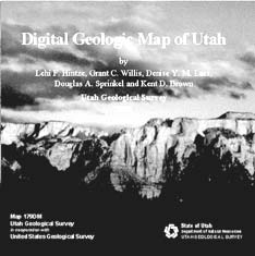
Figure 1. Printed cover for the Digital Geologic Map of Utah CD.
|
As Geographic Information System (GIS) technology becomes a primary tool for resource planning and research among federal, state, and local governments and educational institutions, the pressure to convert existing maps to GIS data is great. The 1:500,000-scale Geologic Map of Utah compiled by Lehi F. Hintze and published by the Utah Geological (and Mineral) Survey (UGS) in 1980 has served for twenty years as the most current geologic map of the entire state. Requests to have this map converted to a digital form have been more numerous than for any other UGS map.
The Digital Geologic Map of Utah, released on compact disc (figure 1) is, in general, identical to the 1980 published map; however, it contains some minor revisions. In addition, this digital release supercedes a digital version of the Geological Map of Utah distributed in 1995 by the geography department at Utah State University, Logan, Utah, which was considered temporary and incomplete.
The digital map is released on CD-ROM, and includes an attractive and easy to use autorun menu system for utilizing the presented data. The spatial data files that comprise the Digital Geologic Map of Utah are provided in both ArcInfo coverages and ArcView shapefiles, and as ArcInfo export files. The files are organized in several folders and subfolders. In addition to spatial data files, the map is provided in Portable Document Format (PDF) and as an ArcExplorer project for map users who do not have GIS software. Adobe Acrobat Reader and ArcExplorer from Environmental Systems Research Institute (ESRI), are freeware programs provided for viewing these files. Text, database, and image files are included to help the user view, evaluate, and utilize the spatial data. The metadata for each coverage or theme are in the respective subfolder that contains the spatial data. The projection of the geospatial data on the CD is Universal Transverse Mercator (UTM) zone 12, North American Datum 1927, and spheroid of Clarke 1866. The units are in meters. More than 400 megabytes of data are included on the CD.
METHODS
The digital geologic map is a cooperative project of the UGS and the U.S. Geological Survey (USGS). The USGS contracted with Optronics Specialty Company, Inc. (19619 Prairie Street, Northridge, CA 91324) to scan, vectorize, and attribute the geologic map in ArcInfo format. Optronics scanned stable-base film positive separates of the original scribed geologic map provided by the UGS. Two separates were used: (1) geologic contacts and faults, and (2) open bodies of water that form boundaries of geologic units or polygons. Original copies of these separates are preserved in archives at the UGS.
Optronics scanned the separates on a high-resolution drum scanner. They then vectorized the resulting raster images using ArcScan and GRID. A published color copy of the geologic map was used as a guide to vectorizing. They compared the resulting line work with the sources by overlaying plots of the digital data and original maps on a light table. The edited vectors were then geographically referenced to UTM zone 12. ArcInfo software was used to produce polygon topology and assign geologic attributes to map features. Optronics determined the identity of map polygons for attributing by visual examination of the color polygons on the published map since many polygons do not have text annotations, and no annotation overlay was available in UGS archives.
The completed digital map was turned over to the USGS. They added line and symbol features such as volcanic cones, gilsonite veins, and igneous dikes by digitizing them from a paper map since no film positive of these layers was available for scanning.
The digital files were then turned over to the UGS for review and preparation for public release. The UGS carefully reviewed a color plot of the digital map to search for polygon and attribution errors. (The contract arrangement stated that Optronics would not attribute polygons for which they could not be sure of the proper geologic map unit identity or that might be in error on the original published map.) The UGS searched original sources to determine the proper identity of unknown or miscolored polygons.
The UGS then made a second round of reviews and corrections to the digital map. In addition, the UGS made a few selected revisions to improve the map from the 1980 version (see below). The UGS then prepared the digital map files, explanatory materials and files, and supporting documents for public release.
As part of the public release the UGS added the following disclaimers, which are used for our printed map publications and were adapted for the digital release.
"This digital map was produced from source mapping at 1:500,000 scale and is not intended for use at larger scales. Enlargement of parts of the map to larger scales may result in incorrect geographic placement or interpretation of geologic features."
"The Utah Geological Survey is not responsible for any unauthorized modification of this data. Any modification of this digital data must be clearly and prominently reported in printed and digital materials produced or distributed by the data modifier, and must not be attributed to, nor implied to be endorsed by, the Utah Geological Survey."
"The views and conclusions contained in this digital and printed map and report are those of the authors and should not be interpreted as necessarily representing the official policies, either expressed or implied, of the U.S. Government."
MODIFICATIONS TO THE
ORIGINAL MAP
The UGS, USGS, and Optronics made extensive effort to accurately reproduce the published 1980 geologic map. In general, the geologic map was not modified or updated to include new mapping or information acquired since 1980. However, during the course of reviewing the digital map it became apparent that some modifications or revisions were required before the digital map could be completed. For example, missing geologic contacts had to be added so polygons could be closed and attributed. Most problems were due to cartographic errors on the published map. We determined the proper or best solution for each revision by consulting the original source maps or other reliable newer maps. The UGS will maintain a file documenting these revisions.
These modifications are of the following types:
- Broken polygons (missing contacts or faults) on the published map. Contacts or faults are missing in several places on the published map, resulting in two different adjacent map units that are not separated by a contact or fault (the colors of the units do differ on the published map). The contact or fault had to be added, otherwise the polygons could not be properly attributed.
- Mislabeled or miscolored polygons on the published map. The reviews identified several mislabeled or miscolored polygons. We corrected these errors by checking against original source maps.
- Mislabeled contacts on the published map. Some of the stratigraphic contacts on the published map are actually marker beds that are within rather than bound polygons, but were not labeled as such. For the digital map, these lines were changed to identify them as marker beds.
- Extra or unidentified polygons or contacts on the published map. The published map has several polygons that are not labeled and are not identified by color as different map units. By checking source materials, we determined that some are legitimate map units that were intended to be on the map, but that were missed during cartographic color preparation. These were properly identified and attributed. Others were found to be extra contacts or polygons that had been inadvertently added to the published map (since some parts of the map were compiled from more detailed sources, the compilers occasionally added extra lines). These were removed. Finally, polygons that bound perennial and intermittent bodies of water were identified and attributed for the digital map as "water" and "playa" respectively.
- Incorrect intersection of water boundaries and geologic contacts on the published map. Open water bodies form the boundaries on one or more sides of many map polygons. In some cases, the contacts do not match properly with the water bodies on the published map. By contacting the persons who worked on the map, we learned that a newer base map with different water body boundaries was added to the 1980 map late in the compilation process, after many contacts were already drafted. Some of the contacts were revised to match the new base, but some were missed, resulting in contacts drafted within the water bodies, or that end before abutting the water boundaries. This was especially evident around the margins of Lake Powell. In these areas, the lines were modified to match the lake boundaries and to properly close polygons.
- Selected updates to the original map. Much new mapping has been completed in Utah since the 1980 map was compiled from sources available at that time. In general, the UGS chose not to revise or update the digital map from the published map. However, though the changes in items 1 through 5 were made to correct cartographic (not geologic) problems, in some cases they may alter the geologic interpretation of the map. In addition, the UGS corrected identifications of a few map polygons that are incorrect on the published map based on the original sources. At the request of L. F. Hintze, the author of the 1980 map, the UGS removed one map unit from the Beaver Dam Mountains in the southwest corner of the map. This map unit does not exist, but was added to the 1980 map due to erroneous source data. Hintze felt that this error has the potential to cause considerable confusion for the map user and should be corrected. We also changed the labeling of the Glen Canyon Group formations (Wingate, Moenave, Kayenta, and Navajo Formations) and the Nugget Sandstone to reflect a Jurassic age rather than a Triassic/Jurassic age. This map unit is now labeled Jg rather than JTR. Though other updates were not made, the UGS does plan to update the digital and printed maps at an undetermined time in the future.
- Modification of state boundary for the digital map. The boundary delineating the state of Utah was adjusted on the digital version of the geologic map to coincide spatially with the boundary of the 1988 U.S. Geological Survey 1:500,000-scale physiographic map of Utah. The 1988 base is used by the Utah Automated Geographic Reference Center (AGRC) as the standard base to create 1:500,000-scale spatial data.
COMPACT DISC CONTENTS
The Digital Geologic Map of Utah is the first formal UGS release of a geologic map in a GIS format. The CD contains many spatial data files (ArcInfo coverages and ArcView shapefiles) of Utah geology, including map units, faults, marker beds, igneous dikes, volcanic (basaltic) cinder cones, and gilsonite veins. Also included on the disc are PDF files of both the digital geologic map and the explanation sheet from the published map. These files include the stratigraphic columns and cross sections from different regions of Utah. Basic geographic spatial data are also included so the user can display the geologic data with familiar geographic themes such as county boundaries, 1:24,000 and 1:100,000-scale quadrangle map indexes, township and range and latitude and longitude grids, and roads using GIS software. Also included is a georeferenced digital raster graphic (DRG) of the topographic base map of Utah. Most of the geographic spatial data were obtained from the AGRC, the central GIS data clearinghouse for Utah state government agencies.
The spatial data, associated metadata, and image files are organized into four folders: (1) coverage, (2) e00, (3) images, and (4) shapes. These folders, except e00, are further organized into subfolders where the spatial data reside. The metadata files (*.met) of the geologic theme (or coverage) and most geographic themes are in the subfolders that contain their respective spatial data (figure 2).
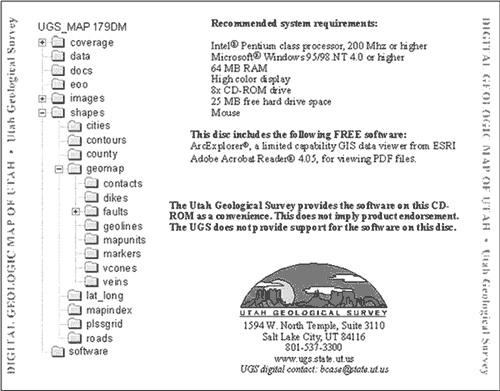
Figure 2. The back cover of the CD showing directory structure.
Several programs located in the software folder can be installed on the user's computer to display data and document files. ArcExplorer 1.1 for Windows 95/98/NT/2000 enables users, who do not already have access to ArcInfo, ArcView, ArcExplorer, or other GIS software, to display ArcInfo coverages and ArcView shape files. An import utility file (Import71) is also included. This utility will convert ArcInfo export files "e00" into ArcInfo coverages.
Adobe Acrobat Reader 4.05 for Windows 95/98/NT/2000 is also included on the CD and is needed to view PDF documents.
The UGS provides ArcExplorer, the ArcExplorer Import Utility, and Acrobat Reader as a convenience and emphasizes that this does not imply a product endorsement. In addition, the UGS does not provide any support for this software. The user is provided with the name and contact information of the software companies for help or additional information regarding their products.
ACCESSING THE FILES
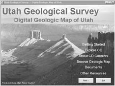
Figure 3. The initial screen of the CD menu system.
|
Much thought and effort went into the decision to use a new autorun menu system with this digital release. We wanted to create a CD product that would be easy to use for both the novice and experienced user. Users familiar with GIS software might simply copy the data files to their computer hard drive and go to work. However, since this digital map will appeal to those with no exposure to GIS, we have created an attractive and simple-to-use menu interface. The software we chose for the creation of the menu system is AutoPlay Menu Studio Professional. We found it is simple to use, very powerful, and capable of the operations we needed.
Insert the CD into the drive and in just a moment the autorun menu (figure 3) appears. The user is greeted with scenic pictures of Utah geology and an uncluttered menu to choose from.
These menu choices include:
- Getting Started - Offers simple instructions for use and a link to installing the ArcExplorer and Acrobat Reader software.
- Explore CD - Explores the CD folder structure.
- About CD Contents - Opens a PDF file describing the contents of the CD.
- Browse Geologic Map - View the geologic map in either PDF format or ArcExplorer project, where the user can perform limited searches. Also, view the explanation sheet as a PDF.
- Documents - Support documents in PDF format.
- Other Resources - WWW links to various sites, from ordering maps online at the UGS to downloading GIS data from the AGRC.
ACKNOWLEDGMENTS
The Digital Geologic Map of Utah was produced through a cooperative agreement between the Utah Geological Survey (UGS) and the U.S. Geological Survey (USGS). Grant Willis (UGS Geologic Mapping program manager) and Gary Raines (USGS Database and Information Analysis (DIA) project chief, Reno, Nevada) developed and directed this project. Ron Goodstein (Optronics Specialty Co. Inc., 19619 Prairie Street, Northridge, CA 91324) managed the scanning, topology, and attributing work on this project through contractual agreement with the USGS. Robert Miller, GIS analyst, directed the GIS work at the USGS. The UGS Economic Geology Program worked on the Utah Mineral Occurrences Database in a cooperative agreement with the USGS as "in-kind" financial support of this project. William F. Case, Chris Ditton, Jon K. King, Michael D. Hylland, and Jim Parker (UGS) reviewed the digital geologic map.
We gratefully acknowledge the efforts of many faculty and students at Utah State University and of Janine Jarva of the UGS (now at AGRC) who worked on the earlier version of the digital map.
ACQUIRING DIGITAL AND PRINTED PRODUCTS FROM THE UTAH
GEOLOGICAL SURVEY
Contact the Natural Resources Map & Bookstore at:
1594 W. North Temple
P.O. Box 146100
Salt Lake City, Utah 84114-6100
Bookstore phone: toll free 888-UTAH MAP (888-882-4627)
801-537-3320
Web address: http://www.maps.state.ut.us/
E-mail address: nrugs.geostore@state.ut.us
UGS receptionist: 801-537-3300
UGS fax: 801-537-3400
U.S.Department of the Interior, U.S. Geological Survey
<https://pubs.usgs.gov/openfile/of00-325/brown.html>
Maintained by Dave Soller
Last updated 11.01.00