By Douglas C. Curl
Kentucky Geological Survey
228 Mining and Mineral Resources Building
University of Kentucky
Lexington, KY 40506-0107
Telephone: (859) 257-5500
Fax:(859) 257-1147
e-mail: dcurl@kgs.mm.uky.edu
- Digital geologic map data (Figure 1)
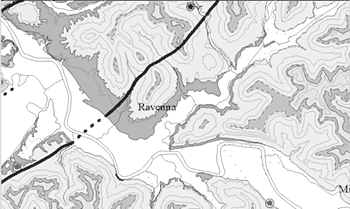
Figure 1. Portion of the Irvine 30 x 60 minute quadrangle map showing the digital geologic data and domestic water well data (double circles). The primary digital geologic data includes lithologic contacts, shown as both inferred (dashed) and known (solid); lithologic polygons; and fault traces (heavy dark solid and dashed lines). |
- Domestic water-well and spring data (Figure 1 and 2)
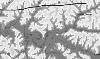
Figure 2. Portion of the Irvine 30 x 60 minute quadrangle map with the USGS Digital elevation models as the base map with an overlay of domestic water well and spring data (double circles). |
- Oil- and gas- well locations (Figure 3)
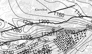
Figure 3. Portion of the Irvine 30 x 60 minute quadrangle map showing oil and gas well locations (dots), and structural contours on the Mississippian Newman Formation (thick grey lines with number labels). The base map here is the digital geologic map data, and the heavy dark lines are fault traces. |
- Structural contour data for several formations, including various coal formations, the Mississippian Newman Formation, the Mississippian "Big Lime" formation (an important oil-producing formation), and the Precambrian basement (Figure 3)
- Coal beds and coal outcrop locations (Figure 4)
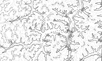
Figure 4. Portion of the Irvine 30 x 60 minute quadrangle map showing coal beds (dark solid and dashed lines), coal outcrop locations (shaded triangles), and fossil locations (grey X's). The base map here is the digital geologic map data. |
- Fossil locations (Figure 4)
- Digital elevation models of USGS 7.5-minute topographic quadrangle maps (Figure 2). The digital geologic map of the Irvine 30 x 60-minute quadrangle is a compilation of data digitized from the original 7.5-minute geologic quadrangle maps. Compiling 32 individual 7.5-minute maps into one 30 x 60 minute map required resolving significant geologic correlation and continuity problems between quadrangles. Stratigraphic and lithologic inconsistencies on most individual 7.5-minute quadrangle maps meant that compilation of maps required geologic evaluation and additional or new data to create an accurate 30 x 60 minute geologic map at a scale of 1:100,000.