USDA Forest Service
NRIS-Terra
16400 Champion Way
Sandy, OR 97055
Telephone: (503) 668-1623
Fax: (503) 668-1410
e-mail: arorick@fs.fed.us
The initial release (v. 1.0) of the terrestrial database, Terra, primarily supports the Forest Service's continuing efforts to inventory, and to classify into "terrestrial ecological units," the biophysical landscapes that comprise the national forests. As a consequence, Terra also supports inventory, classification and mapping of the individual resource components of these ecological units: geology, geomorphology, climate, soils, and potential natural vegetation.
Ecological units delimit areas of different biological and physical potentials, the boundaries of which are determined by integrating the resource components listed above (Cleland et al., 1997). Terrestrial ecological-unit inventories (TEUI) are conducted at a variety of spatial scales, and have proved to be an essential tool in understanding ecosystems: to predict how they will react to disturbances and treatments, to define desired conditions, and to plan for ecosystem sustainability.
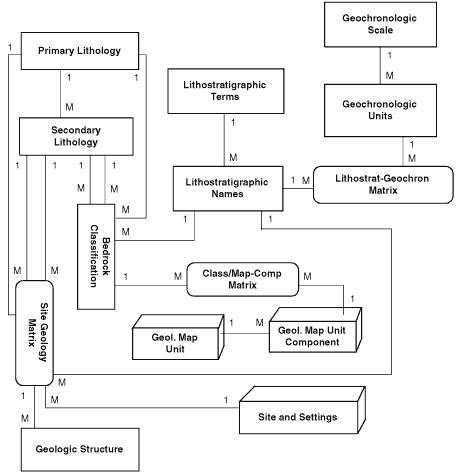
Figure 1.
Simplified relational structure diagram for the geology portion of the Terra database.
Rectangles represent łmaintenanceł type-tables that store values appearing in the
data-entry form drop-down menus. Three-dimensional objects represent the field-data
entry and storage tables. Matrix tables are present to resolve many-to-many relationships.
Geomorphology (after Haskins et al., 1998) is described by process, landform and morphometry, and would require a separate paper to explain.
The development of Terra also required establishment of corporate data standards and protocols for geology, as well as for the other disciplines. Lithology and rock-texture standards come from Travis's Classification of Rocks (1955), which Forest Service and Bureau of Land Management geologists and mineral examiners have been using for many years. Surficial-materials standards are from NRCS's Glossary of Landform and Geologic Terms (1996). The standard for describing rock weathering is derived from the Unified Rock Classification System of Williamson and Kuhn (1988). Stratigraphic nomenclature comes from sections published by USGS or state geological surveys and from the International Stratigraphic Guide (Salvador, 1994). And the geochronology used in Terra is from the DNAG time scale (GSA, 1983).
The data-entry forms developed for Terra serve to enforce these and other standards by accepting only "valid values" in most of the data fields. Type tables developed to house the data elements listed above are stewarded by one geologist: nationally applied standards (e.g., lithology) are under the care of the national data steward; and there are lower levels of stewardship for regionally applicable standards and for local data standards (e.g., the local stratigraphic column). As one would expect, the process for making changes to the standard type-tables becomes increasingly rigorous as the regional scale of their application increases. These type tables are built through "maintenance" forms in Terra, which must be completed before any field-data entry can begin. Metadata forms also must be filled out before any site or map-unit data can be entered. Terra's metadata include project name, field protocols, methodologies, sample designs, examiners, and references.
The field-data entry for Terra is organized by "site" or "polygon," "classification," and "map unit" (figure 1). Site or polygon data describe unique, physical places on the earth, whereas map units are polygons that may occur in many places across the landscape. Sites or polygons are described using the data entry forms specific to the disciplines collecting the data, e.g., geology. There are also site or polygon "setting" data that include location (public land survey, lat-long, UTM, GPS, etc.) and morphometry (elevation, relief, slope, position, drainage, and dissection). "Line" data (e.g., geologic contacts, fold axes, faults, veins, dikes) are currently supported in Terra, only as linear "polygons," however.
The site/polygon geology forms allow selection from lists of values for rock type, texture, weathering, several modifiers (e.g., silicic, calcareous), fracture interval by class (5 classes from <10 cm to >2 meters), surficial cover and depth by class (4 classes from <2 meters to >6 meters), and stratigraphic unit. The form also allows selection of a structure type (e.g., bedding) and direct entry of strike and dip data. Additional forms are filled out for each different lithology that occurs at the site.
The Map-Unit data entry form contains the map-unit symbol (e.g., Mm) and name (e.g., "Madison Formation"), some general location information, and links to other forms where data are entered to describe the unit more thoroughly. The most important of these is the "Map Unit Components" form. Map units are described by their components, labeled "1," "2," etc.). These, in turn, are described by "classifications." Normally, for geological mapping, each map unit will represent a different stratigraphic unit, and will, therefore, have one component, covering 100% of the map unit, and described by a single-taxon classification (e.g., "Mississippian Madison Limestone"). This classification will be attached to every map unit on the geologic map that contains the Madison. This appears redundant, but it is necessary for Terra to be functional for all disciplines using the database and for integrating the data to determine the ecological map units, to which classifications for soils, geomorphology and potential natural vegetation are also attached.
However, should the mapping scale or litho-stratigraphic uncertainties dictate, more than one component can be assigned to the map unit (e.g., an undifferentiated complex of two components: 60% coming from the classification, "Amsden Formation," and 40% from the classification, "Tensleep Sandstone"). Alternatively, one component, again covering 100% of the map unit, could be created using the two classifications, Amsden and Tensleep.
Geologic classifications may be based on either or both the lithology and stratigraphy of the area being investigated. That is, for Forest Service purposes it is often more important to recognize the lithologic component (micritic limestone) of an ecological map unit, rather than whether the stratigraphy is "Madison" or the time period "Mississippian." Such classifications can be created "on the fly" as map-unit components are being established, and as many as are needed can be attached to a particular component.
Once the coverages are developed and the PLA is installed, the spatial display of the data in Terra can be triggered from any of the data-entry forms. For instance, while entering or viewing data about the map unit, Madison Limestone, one can click a button and display the geologic map with the Madison units highlighted. Likewise, by selecting a data point or map unit, or a geographic collection of either, on the ArcView display, the form or series of forms that describes the selected feature or features can be viewed.
Terra also incorporates a set of automated queries, the Terra Extension to ArcView, that spatially displays tabular data from ecological-unit information stored in the database. When the set of data to be displayed, (e.g., lithology or geologic age) is selected from a menu, the data theme or themes are automatically loaded in ArcView and displayed on the map. The extension was developed to display the most common spatial coverages for which Terra stores data, i.e., terrestrial ecological units and the resource components thereof.
In addition, MS Access can be used to develop ad hoc queries from Terra (e.g., select the sites where Madison is the bedrock, colluvium is the surficial material, and liverwort sp. is the dominant vegetation), produce a new table of values, and display them in tabular format, spatially, or both. The data are then available for the various analyses the Forest Service performs.
GSA, 1983, Geologic Time Scale: Decade of North American Geology, Geological Society of America, Boulder, CO.
Haskins, D.M.,Correll, C.S., Foster, R.A., Chatoian, J.M., Fincher, J.M., Strenger, S.,Keys, J.E. Jr., Maxwell, J.M., and King, T., 1998, A Geomorphic Classification System: USDA Forest Service, Washington, D.C., 110 p.
NRCS, 1996, Glossary of Landform and Geologic Terms: USDA National Soil Survey Handbook, National Soil Survey Center, Lincoln, NE.
Salvador, A, ed., 1994, International Stratigraphic Guide: a Guide to Stratigraphic Classification, Terminology and Procedure: Geological Society of America, Boulder, CO. 214 p.
Travis, R.B., 1955, Classification of Rocks: Quarterly of the Colorado School of Mines, v. 50, no. 1, 98p.
Williamson, D.A. and Kuhn, C.R., 1988, The Unified Rock Classification System, in L. Kirkaldie, ed., Rock Engineering Systems for Engineering Purposes, ASTM STP 984: American Society for Testing Materials, Philadephia, PA, pp. 7-16..