Open-File Report 01-190
The STRATAFORM Project: U.S. Geological Survey Geotechnical StudiesBy Diane L. Minasian, Homa J. Lee, Jaques Locat, Kevin M. Orzech, Gregory R. Martz,
|
| The Northern California study area, located off the coast of Eureka, between Cape Mendocino and Trinidad Head, is an ideal location to investigate the occurrence of mass wasting and sediment transport and deposition (Nittrouer and Kravitz, 1996). This seismically active area receives an abundant amount of fluvial sediment, primarily from the Eel River (mean sediment discharge >107 t/y). Moreover, sediment is reaching the slope and accumulating at a relatively rapid rate of 1-4 mmy-1 (Alexander, 1996). The combination of this rapid sedimentation with frequent earthquake activity can cause slope deposits to fail. Because many shelf and slope sedimentary processes are active in this region, it makes it an excellent area to study geotechnical impact on the strata (Nittrouer and Kravitz, 1996). | 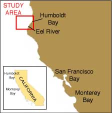 |
The piston core device consists simply of a weight stand mounted above a length of stainless steel core barrel (Kullenburg, 1955). A plastic liner, housing a fitted piston, is inserted into the core barrel to contain the sample. The lifting cable is fitted into a trigger arm with a slack loop and tension is applied by a separate trigger weight. Then, the device is lowered to the sea floor at a constant velocity and the trigger weight is allowed to impact the sea floor releasing the trigger arm and allowing the corer to free-fall a calibrated distance to the sea floor. While penetrating, the piston creates a partial vacuum state within the core liner, thus improving the amount of sample recovered (Noorany, 1972). The device is then returned to the ship's deck, where the sediment core is removed from the core barrel. The sediment cores are then run through the multi-sensor logger. These physical property results have been used to develop a better understanding of spatial variability of marine sediment properties (Goff et al., 2002). They have also been used as a basis for developing a method for predicting the regional variability of submarine landslide susceptibility (Lee et al., 1999, 2000). Other investigators within the STRATAFORM Program use these physical property data to estimate variations in stratigraphic characteristics both with depth below the seafloor and over the Northern California study area.
Sediment cores were logged to gather data of physical properties in conjunction with four cruises to the Eel margin study area (Northern California study area): the first aboard the R/V Wecoma in 1995(W9509), the second from the R/V Thomas Thompson in 1996 (TNO62), the third aboard the R/V Melville in 1997 (M9707), and the latest again aboard the R/V Wecoma in 1998 (W9807A). Homa J. Lee was the principle investigator from the USGS on each of the cruises, accompanied by principle investigators from other institutions. Numerous USGS employees also participated in the cruises. The following, delineated by the respective STRATAFORM IDs of each cruise (USGS IDs are in parentheses), summarizes the goals and subsequent accomplishments of the cruises.
| CLICK HERE TO LINK WITH INDEX MAP OF STUDY AREA |  |
To view the procedures used for editing, graphing, naming and working with STRATAFORM logger data CLICK HERE. |
The STRATAFORM program is a multi-investigator study that is primarily funded by the Office of Naval Research. The program began in 1994 with Joseph H. Kravitz as the ONR Program Director and Charles A. Nittrouer (presently of the University of Washington) as Program Coordinator. Roy Wilkins, Jill Karsten, Dawn Lavoie, Stephen Martin, and Thomas Drake have subsequently been ONR program directors. All of their support is gratefully acknowledged. Support for the USGS portion of the program was provided by the Office of Naval Research and the USGS Coastal and Marine Geology Program.
Alexander, C.R., 1996. Slope sedimentation on the Eel River continental margin, EOS Transactions, American Geophysical Union, Vol. 76, OS 10.
Boulanger, E., Locat, J., Desgagnés, P., Martin, F., and Lee, H.J., 1998. Geotechnical testing of Eel River sediments collected as part of the R/V Wecoma Cruise # W9807A (July 14 - 25, 1998). Department of Geology and Geological Engineering, Laval University, Quebéc, CANADA, GREGI Report 98-20, 45 p.
Cottage, F. and Lane, M., 1990. The automated multi-sensor whole core logging system, A manual on the prototype system built for the United States Geological Survey in 1990, 20p.
Desgagnés, P., Locat, J., Lee, H.J., Leroueil, S., Alexander, C., Mountain, G., and Pratson, L., 2000. Geotechnical properties of a mass flow deposit on the Hudson Apron, off New Jersey, USA, Proc., 53rd Conf. Canadienne de Geotechnique, Montreal.
Edwards, B.D. and Gardner, J.V., 1995. Operator's quick guide to USGS multi-sensor logging procedures, Technical Publication No. 95-2, 8p.
Field, M.E., and Barber, J.H., Jr., 1993. A submarine landslide associated with shallow sea-floor gas and gas hydrates off northern California, Submarine Landslides: Selected Studies in the U.S. Exclusive Economic Zone, U.S. Geological Survey Bulletin 2002, pp. 151-157.
Goff, J.A., Wheatcroft, R.A., Lee, H., Drake, D.E., Swift, D.J.P., and Fan, S., 2002. Spatial variability of shelf sediments in the STRATAFORM natural laboratory, Continental Shelf Research, 22, 1199-1223.
Hampton, M.A., Lee, H.J., and Locat, J., 1996, Submarine landslides, Reviews of Geophysics, v. 34, p. 33-59.
Imran, J., Parker, G., Locat, J., and Lee, H., 2001. 1D numerical model of muddy subaqueous and subaerial debris flows, Journal of Hydraulic Engineering, ASCE, 127, 959-968.
Kayen, R.E., Edwards, B.D., and Lee, H.J., 1999. Nondestructive laboratory measurement of geotechnical and geoacoustic properties through intact core-liner. in: W.A. Marr (ed.),Nondestructive and automated testing for soil and rock properties, American Society for Testing and Material (ASTM) Special Technical Publication STP-1350.
Kayen, R.E., and Phi, T.N., 1997. Using Hypercard for robotic control and data collection,SciTech Journal, Vol. 7, No. 5, pp. 24-29.
Kullenburg, B., 1955. Deep-sea coring: Rept. Swedish deep-sea Expedition IV. Bottom Investigations, No. 2, pp. 51-76.
Lee, H.J., Kayen, R.E., Gardner, J.V., and Locat, J., 2003. Characteristics of several tsunamigenic submarine landslides, Proceedings, First International Symposium on Submarine Mass Movements, Nice, France (11 pp., in press)
Lee, H.J., Locat, J., Dartnell, P., Minasian, D., and Wong, F., 2000, A GIS-based regional analysis of the potential for shallow-seated submarine slope failure, Proc., 8th International Symposium on Landslides, Cardiff, Wales, June, 2000, p. 917-922.
Lee, H.J., Locat, J., Dartnell, P., and Wong, F., 1999, Regional variability of slope stability: application to the Eel Margin, California, Marine Geology, 154, 305-321.
Lee, H.J., Schwab, W.C., and Booth, J.S., 1993. Submarine landslides: An introduction,Submarine Landslides: Selected Studies in the U.S. Exclusive Economic Zone, U.S. Geological Survey Bulletin 2002, pp. 1-6.
Lee, H.J., Syvitski, J.P.M., Parker, G., Orange, D., Locat, J., Hutton, J.W.H., and Imran, J., 2002. Distinguishing sediment waves from slope failure deposits: field examples, including the ‘Humboldt Slide’ and modelling results, Marine Geology, 192, 79-104.
Leroueil, S., Vaunat, J., Picarelli, L., Locat, J., Lee, H., and Faure, R., 1996, Geotechnical characterization of slope movements, Proceedings of the International Symposium on Landslides, Trondheim.
Locat, J., Gardner, J.V., Lee, H., Mayer, L., Hughes-Clarke, J.E., and Kammerer, I., 1999. Using multibeam sonar surveys for submarine landslide investigations, Proc. of the International Symposium on Slope Stability Engineering, Shikoku, Japan, p. 127-134.
Locat, J. and Lee, H.J., 2003. Submarine landslides: advances and challenges, Canadian Geotechnical Journal, vol. 39, 193-212.
Locat, J, Lee, H., Kayen, R., Israel, K., Savoie, M.-C., and Boulanger, E., 2002. Shear strength development with burial in Eel River margin slope sediments, Marine Geotechnology, 20, 111-136..
Locat, J., Locat, P., and Lee, H.J., 2003. Numerical analysis of the mobility of the Palos Verdes debris avalanche, California, and its implication for the generation of tsunamis, Marine Geology, Marine Geology.
Locat, J., Tanaka, H., Tan, T.S., Dasari, G.R., and Lee, H., 2002. Natural soils: geotechnical behavior and geological knowledge, Proceedings, International workshop on Characterisation and engineering, Properties of Natural Soils, Singapore, Dec. 2-4, 2002, 27 pp.
Niedoroda, A.W., Reed, C.W., Swift, D.J.P., Arato, H., and Hoyanagi, K., 1995. Modeling shore-normal large-scale coastal evolution, Marine Geology, 126, pp. 181-199.
Nittrouer, C.A., and Kravitz, J.H., 1996. STRATAFORM: A Program to study the creation and interpretation of sedimentary strata on continental margins, Oceanography, Vol. 9, No. 3, pp. 146-152.
Nittrouer, C.A., and Kravitz, J.H., 1995. Integrated continental margin research to benefit ocean earth sciences, EOS, Transactions, American Geophysical Union, Vol. 76, No. 12, pp. 121, 124, 126.
Noorany, I., 1972. Underwater soil sampling and testing--A state-of-the-art review, Underwater Soil sampling, Testing and Construction Control, ASTM STP 501, American Society for Testing and Materials, pp.3-41.
Orange, D.L., McAdoo, B.G., Moore, J.C., Tobin, H., Screaton, E., Chezar, H., Lee, H., Reid, M., and Vail, R., 1997. Headless sugbmarine canyons and fluid flow on the toe of the Cascadia accretionary complex, Basin Research, 9: 303-312.
Pratson, L.F., Lee, H.J., Parker, G., Garcia, M.H., Coakley, B.J., Mohrig, D., Locat, J., Mello, U., Parsons, J.D., Choi, S-U, and Israel, K., 1996. Mass-movements on submarine slopes, Oceanography, Vol. 9, No. 3, pp. 168-172.
Rosfelder, A.M., and Marshall, N.F. 1967. Obtaining large, undisturbed, and oriented samples in deep water, Marine Geotechnique, Proceedings of the International Research Conference on Marine Geotechnique 1966. pp. 243-264.
Syvitski, J.P., Alexander, C.R., Field, M.E., Gardner, J.V., Orange, D.L., and Yun, J.W.,1996. Continental-slope sedimentation: The view from northern California, Oceanography, Vol. 9, No. 3, pp.163-167.
Syvitski, J.P., Nicholson, M., and Skene, K., 1995. Application of hydrologic model RIVER 4.1 to Eel River basin, California, a flood-dominated basin, EOS, Transaction, American Geophysical Union, Vol. 76, No. 12, p. F240.
Wiberg, P.L., Cacchione, D.A., Sternberg, R.W., and Wright, L.D., 1996. Linking sediment transport and stratigraphy on the continental shelf, Oceanography, Vol. 9, No. 3, pp.153-157.
Any use of trade, product, or firm names is for descriptive purposes only and does not imply endorsement by the U.S. Government.
Suggested citation:
Author1, F.N., Author2, Firstname, 2001, Title of the publication (version, new publication date-if applicable): Place of publication
(unless it is a corporate entity) Publisher, number or volume, page numbers, DOI URL.
U.S. Department of the Interior
SALLY JEWELL, Secretary
U.S. Geological Survey
Suzette M. Kimball, Acting Director

![]() U.S. Department of the Interior |
U.S. Geological Survey
U.S. Department of the Interior |
U.S. Geological Survey
URL: http://pubsdata.usgs.gov/pubs/of/2001/0190/intro.html
Page Contact Information: GS Pubs Web Contact
Page Last Modified: Wednesday, 07-Dec-2016 18:57:14 EST