Surficial Geology and Distribution of Post-Impoundment Sediment in Las Vegas Bay, Lake Mead
Results
Delta Morphology
Click on each figure for larger image with caption.
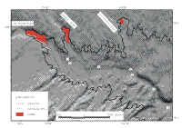
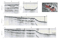
Deltas have formed off the mouths of Las Vegas, Gypsum, and Government Washes, and of these, the one at the mouth of Las Vegas Wash is the largest. It extends into the lake approximately 800 m, has a smooth delta top that increases to 6-m depth at the edge of the delta, at which point the depth rapidly increases to 20 m over the next 200 m (Fig. 7 and Figs. 8C, D). Two tie lines, one in deep water in front of the delta and the second on top of the delta, show how this steep-sided valley has been completely filled by these deltaic deposits (Figs. 8 A, B). In Gypsum Wash, the delta is smaller: it extends into the lake approximately 600 m (Fig. 7), has a smooth delta top that increases to 8-m depth at the edge of the delta, and has an 80-m-wide delta front with about 4-m relief. This delta-front is not as steep as the one in Las Vegas Wash. In Government Wash, the delta is smaller and shallower. It extends into the lake about 180 m, the edge of the delta is at 5-m depth, and the delta front has 2-m relief.
|