Surficial Geology and Distribution of Post-Impoundment Sediment in Las Vegas Bay, Lake Mead
Results
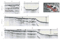
Sidescan Sonar Imagery
Click on each figure for larger image with caption.
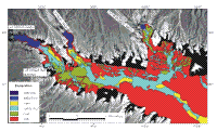
The sidescan sonar imagery was used to identify six surficial units: one was outcrop of preimpoundment rocks and five were post-impoundment sedimentary deposits
(Fig. 3 and Fig. 4). Areas of rock outcrop show either as a uniform high-backscatter signature,
which coincide mostly with smooth surfaces, or as alternating bands of high and low backscatter, which coincide with stepped surfaces (Fig. 9 and Fig. 10).
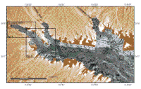
Commonly the areas of rock outcrop are found along the steep walls of the submerged valleys and their tributaries (Fig. 4). The strata that crop out on the floor of Las Vegas Bay presumably are the same Tertiary-aged tuffaceous sedimentary strata that make up the landscape surrounding most of this part of the lake (Stewart and Carlson; 1978). The only exceptions are Quaternary-aged alluvial deposits found in the floors of the subaerially exposed parts of Las Vegas, Gypsum, and Government Washes (Stewart and Carlson; 1978).
Sediments that are interpreted to be post-impoundment in age primarily occupy the submerged stream beds. We divide them into five units that reflect different sediment types or different depositional processes. Two of these units are associated with the deltas found off the mouths of Las Vegas, Gypsum and Government Washes. The other three units are found beyond the toes of the deltas in the deeper parts of Las Vegas Bay (Fig. 4).
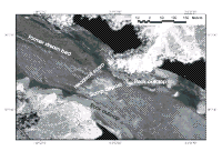
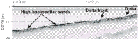
The surficial geology of the deltas has been broken into two units, delta-top deposits and delta-front deposits. The three deltas vary in size with the one off Las Vegas Wash being the largest yet the surficial geology is similar on all three. The delta top deposits are characterized primarily by a moderate backscatter that is interrupted by high-backscatter patches (Fig. 9). These high-backscatter patches are probably localized exposures of gravel and coarse sand that comprise the deltaic deposits. On the delta off Las Vegas Wash, a sinuous high-backscatter band extends along the axis of the delta to the delta front. An aerial photograph taken in 1996 when the lake was 4-6 m lower than when this survey was completed shows a stream bed crossing the exposed part of the delta (Fig. 9A). The high-backscatter band in the sidescan image coincides with this stream channel (Fig. 9 B). The strong acoustic signature probably is associated with coarser-grained material deposited in the stream bed.
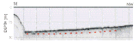
The delta fronts, by contrast, have steeper slopes (Figs. 8C,D, and Fig. 9C) and a high-backscatter signature on the sidescan image (Fig. 9B, and Fig. 10). Along the top of the delta front off Las Vegas Wash are several arcuate scarps upslope of the high-backscatter area. These scarps are interpreted to be slope-failure scarps, and the high-backscatter area downslope of the scarps is the deposit derived from these failures (Fig. 10). Off Gypsum and Government Washes the delta fronts have a high-backscatter signature that is interpreted to be the result of slope failures as well. However, because of their smaller sizes the failure scarps cannot be resolved.
Beyond the toes of these three deltas, the sediment-covered part of the study
area has been divided into three depositional units based on the sidescan sonar imagery. Visual descriptions of short cores collected during this study support this interpretation. The three units include sandy deposits that have a high-backscatter signature on the sidescan image, sandy to silty mud that has a moderate-backscatter signature, and mud that has a low-backscatter signature. An example of these different units is shown in Figure 11, and their distribution is shown in Figure 4.
The high-backscatter sand occurs immediately beyond the deltas off Las Vegas and Gypsum Washes, but is not present off Government Wash (Fig. 4).
Off Las Vegas Wash the sandy deposits are concentrated along the eastern side of the lake floor and form a continuous sheet near the toe of the delta that breaks into series of dune-like features farther from the delta (Fig. 11). The surficial expression of this sand deposit is not connected with the delta itself. The distribution of sandy deposits on the lake floor off Gypsum Wash is quite different from that found off Las Vegas Wash. Here a thin high-backscatter band can be traced nearly 400 m from the toe of the delta front to where it opens into a 200-m by 150-m high-backscatter patch (Fig. 12).
Mud is found in discontinuous patches along the flanks of the deltas off the washes and covers a large area at the confluence of the submerged valleys originating from Las Vegas and Gypsum Washes (Fig. 4). The one core recovered from this unit was unconsolidated mud. This mud appears to be filling lows in the original valley floor. The cover is incomplete and the sidescan imagery shows areas of rock outcrop still exposed in this area (Fig. 11).
Much of the sedimentary cover on the lake floor beyond the deltas is sandy mud or a thin mud veneer overlying sand. On the sidescan imagery, this unit has a moderate-backscatter signature (Fig. 3, and Fig. 4). One core from this unit recovered approximately 20 cm of mud with some sand in the core catcher. Whether this deposit is a sandy mud or alternating beds of sand and mud cannot be resolved in this core. The moderate backscatter signature that is associated with the sandy mud deposit can be traced down the axis of Las Vegas Bay past the edge of this survey on the sidescan imagery collected in 1999 (Twichell and others, 1999).
|