Surficial Geology and Distribution of Post-Impoundment Sediment in Las Vegas Bay, Lake Mead
Results
Post-Impoundment Sediment Distribution and Thickness
Click on each figure for larger image with caption.
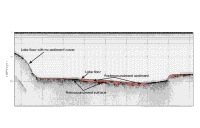
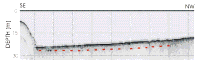
The distribution and thickness of sediment that has accumulated since impoundment are shown in Figure 6. This sediment is identified on the seismic-reflection profiles as an acoustic unit that overlies a moderate to highly reflective horizon (Fig. 5).
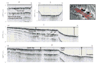
This unit commonly is acoustically transparent, but, particularly where it is thicker, reflectors are present within it (Figs. 13A, B).
The base of the post-impoundment sediment could be traced throughout the study area except under the delta off Las Vegas Wash. Here, as was described in the Methods section, the preimpoundment surface as identified on the digital elevation model had to be used as the base for these deposits.
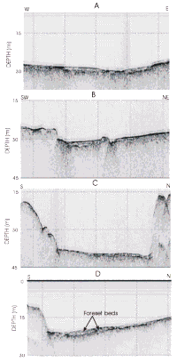
The reason the Knudsen seismic system could not penetrate the sediment in this delta was largely because of a highly reflective horizon shallow in the delta deposit (Figs. 8A, C, D). Figures 8A and C show this high amplitude reflector about 1 m below the lake floor. Coring on the delta top was difficult, and little sediment was recovered. Gravity cores came up empty, or, at most, had some gravel clasts in the core catcher. Mud on the outside of the core barrel suggested a discontinuous blanket of mud covers the gravel.
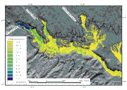
Post-Impoundment sediment is limited to the floors of the submerged valleys (Fig. 6).
It exceeds 13 m in thickness in the delta at the mouth of Las Vegas Wash, thins lakeward, and in most of Las Vegas Bay this sediment cover is less than 1.5 m thick (Fig. 13C). There are some localized patches where the sediment cover exceeds 2 m in Las Vegas Bay, but the major areas where sediment is more than 2 m thick are off the mouths of Gypsum and Las Vegas Washes (Fig. 6). Off Las Vegas Wash the sediment exceeds 13 m under much of the delta, but a thinner tongue of sediment extends beyond the delta for nearly 1 km and ends near Las Vegas Bay Marina in approximately 25 m of water. This tongue of sediment is mostly 2-4 m thick, but it thins abruptly immediately south of Las Vegas Bay Marina against a rock ledge that the sidescan imagery shows extending almost across the Wash (Fig. 11).
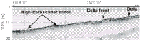
Off the mouth of Gypsum Wash the thickest sediment is 2-3 m. The thickest part of the deposit comprises the outermost part of the delta and a tongue that extends beyond the delta front (Fig. 12). The thick part of the deposit extends beyond the delta front approximately 350 m before thinning in approximately 20 m of water (Fig. 6). Off Government Wash a pod of sediment that is much smaller in areal extent and barely exceeds 2 m in thickness occurs at this same 20-25-m depth of water as well.
|