| |  |  | | Lake Pontchartrain Atlas: | | | | | | | | | | | | | | | | Environmental Status & Trends |  | | | | | | | | | | | | | | | | | | | | | | | | | | | | |  | | | | | | | | | | |  | Environmental Status and Trends - Status and Trends of the Lake Pontchartrain Basin Contributors: Penland, Maygarden, Beall The Manchac Land Bridge Area (MLBA) encompasses the swamps, forests and marshes that form the land bridge between Lakes Maurepas and Pontchartrain (Figures 1 and 5). The Tangipahoa and Tchefuncte watersheds drain into this area. The MLBA contains approximately 99,517 acres of primarily swamp and bottomland hardwood forest with isolated pockets of fresh marsh. Much of the swamp and forest in the MLBA was logged in the early Twentieth Century, and in many cases, regeneration has been hampered by a number of factors including subsidence, saltwater intrusion and herbivory by nutria. At the University of Southeastern Louisiana's Turtle Cove Environmental Research Station, extensive cypress replanting projects have been underway for several years. Although they are successful overall, the project faces many challenges because of these factors. Between 1956 and 1990, there was a habitat change trend from freshwater marsh to intermediate marsh as higher salinity water penetrated. Since the construction of the MRGO, more saline water introduced into Lake Pontchartrain, North Pass and Pass Manchac can penetrate farther into wetlands via oil and gas access canals and the borrow canal for U.S. Interstate 55. There has been a marked decrease in swamp productivity due to the stresses of altered hydrology, flooding and subsidence. 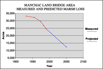 | | Figure 7: Measured marsh loss rates of the MLBA between 1932 and 1990 with projections to 2050 (Coast 2050, 1998). Refer to Table 5 for marsh loss comparison. | Figure 7 Illustrates the loss of marsh in the MLBA . The MLBA lost 8,430 acres of marsh (25%) between 1932 and 1990 (Table 5). The loss was primarily due to shoreline erosion, although altered hydrology, flooding, subsidence, herbivory and direct removal are also important factors. The subsidence rate in this area is significant at between 0.3 m and 0.6 m (1.0 and 2.0 ft) per century. The area is also projected to experience a 50% loss of marsh between 1990 and 2050 (Table 5). The natural process of shoreline erosion will continue to be a primary cause of land loss while altered hydrology, flooding, subsidence and herbivory are expected to increasingly stress the swamps. Urban development is taking place in the MLBA, especially in the vicinity of Madisonville, and will continue to encroach upon an unknown amount of hardwood and mixed pine forest as well as marginal wetland areas on the northern edges of this region. Within the MLBA are the Joyce and Manchac Wildlife Management Areas, both managed by the LDWF. The entire area is extremely important to many other species of wildlife. Two federally listed threatened species, the bald eagle and Gulf sturgeon, are found in the MLBA. There was one active bald eagle nest documented there during the 1996-1997 breeding season. The anadromous Gulf sturgeon is found in the Tangipahoa River, where it is believed to spawn. For status and trends of animal populations in this area, please refer to Tables 2, 3 and 4. In general, these statistics show steady populations for the area, with a decline in brown shrimp and an increase in alligator and wading bird populations. « Previous | Next » |
