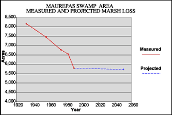
| |  |  | | Lake Pontchartrain Atlas: | |  | | |  | | |  | | |  | | |  | | Environmental Status & Trends |  | |  | | |  | | |  | | |  | | |  | | |  | | |  | | |  | | |  |  | |  | |  | | |  |  |  | | | |  | Environmental Status and Trends - Status and Trends of the Lake Pontchartrain Basin Contributors: Penland, Maygarden, Beall The Maurepas Swamp Area (MSA) is the westernmost portion of the Marginal Deltaic Basin geomorphic region (Figure 1). It encompasses Lake Maurepas and the surrounding swamps, forests and marshes (Figure 3), as well as the lower watersheds of the Amite and Tickfaw Rivers (Figure 5). The MSA contains approximately 232,928 acres of mostly swamp with some isolated areas of bottomland hardwood forest and fresh marsh. After the intensive logging of the early Twentieth Century, the swamps regenerated in the Maurepas area, and. between 1956 and 1990, there was no significant habitat change in the area. However, there was a marked decrease in swamp productivity during this period due to subsidence, flooding and altered hydrology. In addition, since the completion of the MRGO in 1963, higher-salinity water has periodically intruded the area in spite of its remoteness from the source. The higher-salinity water penetrates these swamp areas via oil and gas canals as well as the U.S. Interstate 55 borrow canal, putting these freshwater habitats under stress. Herbivory by nutria has also slowed the cypress swamp regeneration process.  | | Figure 6: Measured marsh loss rates of the Maurepas Swamp Area between 1932 and 1990 with projection to 2050 (Coast 2050, 1998), refer to Table 5 for marsh loss comparison. | Figure 6 Shows marsh loss between 1932 and 1990 and projected through 2050. There was a 29% loss of marsh between 1932 and 1990 and a rate is projected through 2050 (Table 5). The area contains more swamp than marsh habitat. The Coast 2050 projection shows an expected 47% loss of swamp habitat for the 1990 to 2050 period. No data were available for loss of swamp between 1932 and 1990. The primary causes of land loss in this area are natural shoreline erosion, altered hydrology, subsidence and direct removal related to human activities. Subsidence in this area is occurring at a rate of around 0.3 m (1.0 ft) per century, which is considered to be a relatively low to moderate rate in coastal Louisiana. Shoreline erosion will continue to be a major cause of loss in this area in the future, while altered hydrology, flooding, subsidence, elevated salinities and herbivory are expected to continue to increasingly stress these swamps. The MSA is extremely important habitat for neotropical migratory songbirds, waterfowl and many other species of wildlife. Two threatened species listed by the Federal Endangered Species Act, the bald eagle and Gulf sturgeon, are commonly found in this area. Bald eagles typically nest in cypress trees near fresh to intermediate marshes or open water. There were 15 active bald eagle nests in this area during the 1996 to 1997 breeding season. The anadromous Gulf sturgeon is a threatened species found in the Amite and Tickfaw Rivers as well as Lake Maurepas. The status and trends of a selection of fish and wildlife populations of the MSA can be found in Tables 2, 3 and 4. Generally, most animal populations show a steady population numbers, however, the numbers of alligators, wading birds and woodland birds are increasing. « Previous | Next » |

