| |  |  | | Lake Pontchartrain Atlas: | | | | | | | | | | | | | | | | Environmental Status & Trends |  | | | | | | | | | | | | | | | | | | | | | | | | | | | | |  | | | | | | | | | | |  | Environmental Status and Trends - Status and Trends of the Lake Pontchartrain Basin Contributors: Penland, Maygarden, Beall 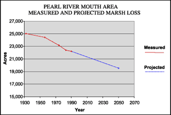 | | Figure 12: Measured marsh loss in the Pearl River Mouth Area between 1932 and 1990 with projection to 2050 (Coast 2050). Refer to Table 5 for marsh loss comparison. | The Pearl River Mouth Area (PRMA) forms the lower end of the Pearl River watershed and the eastern border of the Lake Pontchartrain Basin (Figure 1). The Pearl River watershed is extensive and includes the Pearl and Bogue Chitto Rivers, which have their sources in the state of Mississippi (Figure 5). The broad floodplain of the lower Pearl River valley is occupied by bottomland hardwood forest and swamp that give way to fresh and intermediate marshes close to the mouth of the Pearl River in Lake Borgne. The PRMA includes only this lower marsh area. The valley to the north is considered part of the Pleistocene Terraces geomorphic region. Parts of the PRMA receive regular flow of fresh water from the Pearl River and its distributaries and have not suffered badly from erosion. However, the portion of the area known as Fritchie Marsh has suffered from altered hydrology, impoundment and saltwater intrusion. Figure 12 illustrates the steady loss of marsh that has occurred in the PRMA since 1932. Shoreline erosion and herbivory are also responsible for some of this loss. Presently, Fritchie Marsh is the focus of a CWPPRA project to restore the hydrology of the marsh. This project is designed to restore freshwater flow from the Pearl River and is predicted to reduce the projected marsh loss rate. The lower Pearl River watershed is classified by the EPA's IWI as having more serious water quality problems, but low vulnerability (Water Quality). It is listed by the LDEQ as a state impaired water with mercury and pathogen pollution being among the impairments. It does not meet its designated use standards for fish consumption and carries a fish consumption advisory due to mercury contamination. However, the lower Pearl River does not have an advisory against swimming. The Pearl River Mouth Area is vitally important habitat for a great variety of wildlife. It contains the Bogue Chitto National Wildlife Refuge, Pearl River Wildlife Management Area and Nature Conservancy White Kitchen Preserve. Several federally listed species occur in the PRMA, including the threatened bald eagle and Gulf sturgeon and the endangered heelsplitter mussel. The status and trends of a selection of fish and wildlife of the PRMA are found in Tables 2, 3 and 4. « Previous | Next » |
