Basin Geology - Quarternary Framework Contributors: Kulp, Howell, and Lopez Introduction There are two distinct subsurface fault systems in Lake Pontchartrain. In the southern half of the Lake are inactive South Louisiana Tertiary Basin faults and in the northern half of the Lake is an active portion of the Baton Rouge-Denham Springs (BR-DS) fault system. The active BR-DS faults are shown on the map (Figure 27) and described in detail below.  | | Figure 27: Fault map depicting the Baton Rouge-Denham Springs (BR-DS) Fault System in Lake Pontchartrain. | Subsurface geologic faulting is common throughout most of the Louisiana coast due to the underlying presence of a thick Tertiary Basin. Lake Pontchartrain is located on the northern margin of the South Louisiana Tertiary Basin and faults in the southern portion of the Lake have a style typical of the Tertiary Basin. The northern and western portion of the Lake is underlain by a regional fault system associated with the Lower Cretaceous margin, which is also the major boundary for the Tertiary Basin (Lopez, 1997). The BR-DS fault system is sub-parallel to the margin and runs roughly northwest-southeast from Baton Rouge towards Lake Pontchartrain (Durham, 1982; Snead and McCulloh, 1984). The fault system is composed of mostly sub-parallel or en echelon faults which step southward as the fault system continues eastward from Baton Rouge through the area north of Lake Maurepas and into Lake Pontchartrain. The position of the BR-DS fault system is undoubtedly related to the deeper tectonic elements reflected by the Lower Cretaceous margin and Tertiary hinge line which the BR-DS fault system parallels. However, the cause for recent activity of the BR-DS faults in Lake Pontchartrain is unclear. Faulting in Lake Pontchartrain and elsewhere along Louisiana's coast is currently being investigated at the UNO. The BR-DS faults in Lake Pontchartrain have been identified through "conventional" oil and gas seismic profiles, high-resolution seismic and fault offset along bridge structures. This BR-DS fault system in Lake Pontchartrain is composed of four faults. All of these faults are south dipping, normal faults which form a southeasterly trend of en echelon fault surface traces. All of these faults extend from the surface (i.e. the Lake's bottom) to a minimum depth of 20,000 ft. The faults generally dip 45 to 65 degrees from horizontal. The four BR-DS faults (designated here as South Point Fault, Goose Point Fault, Causeway Fault and Madisonville Point Fault) are generally moving with relative offset of 0.1 inch/yr (2.54 mm/yr). However, some evidence suggests movement rates as high as 0.4 inches/yr (10.16 mm/yr). The faults were probably active in the Miocene, Late Pleistocene and the Recent. 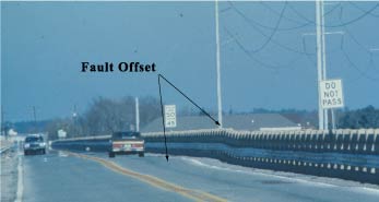 | | Figure 28: Goose Point fault offsets N. Highway 11 bridge structure by at least 6 inches. View is to the North and the normal fault dips south. | South Point Fault
The South Point Fault is the most eastern BR-DS fault located in Lake Pontchartrain. It is named after South Point, located on the eastern south shore of the Lake where the Norfolk-Southern Railroad Bridge makes landfall. The fault is at least 14.5 km (9 mi) long and may extend further east across a peninsula of land and into Lake Borgne. The fault visibly offsets the 1960 U.S. Interstate 10 twin bridges by approximately 7.6-10.2 cm (3-4 in) at 0.48 km (0.3 mi) north of the south shore. Westward 2,000 ft the fault offsets the 1928 Highway 11 Bridge by approximately 12.7-15.2 cm (5-6 in), seen 0.32 km (0.2 mi) from the south shore. The Norfolk-Southern Railroad is another 1.4 km (0.9 mi) west of the Highway 11 Bridge and was rebuilt here in 1987. The railroad has approximately 7.6 cm (3 in) of offset. Goose Point Fault
The Goose Point Fault extends from Pass Rigolets westward past Goose Point for 27.4 km (17 mi) and is the longest BR-DS fault identified in Lake Pontchartrain. The fault can most clearly be seen 1.05 km (0.65 mi) from the north shore where it crosses the Highway 11 Bridge and offsets the structure by at least 15.2 cm (6 in) (Figure 28). The nearby Norfolk-Southern Bridge was rebuilt here in the late 1990's and the most recent effect from the fault is not yet determined on the new structure. The U.S. Interstate 10 Bridge does have a slight dip at the north base of the elevated boat crossing section which is likely due to the Goose Point Fault. Vibracores taken at Highway 11 indicate the Pleistocene is offset by approximately ten ft and the Holocene has significant sediment expansion across the fault. Causeway Fault
The Causeway Fault is 11.3 km (7 mi) long and is the shortest BR-DS fault identified in the Lake. The fault can be seen on the older south-bound span of the Causeway Bridge approximately 5.0 km (3.1 mi) from the north shore. This span has at least 7.6 cm (3 in) of visible offset. The newer north-bound Causeway Bridge was built in 1969 and probably has slight offset, but has not been confirmed. Madisonville Point Fault
The 14.5 km (9 mi) long Madisonville Point Fault is named after the slight point found west of the town on Madisonville. It has been identified on "conventional" and high resolution seismic and where the fault makes landfall in the northwest corner of Lake Pontchartrain. The fault does not appear to cross any bridges in Lake Pontchartrain, which might otherwise document its most recent activity. It is suspected that the fault is active since it persists up to the Lake bottom on high-resolution seismic. | Conversion Factors | | 1 in = 2.54 cm | | 1 ft = 0.3028 m | | 1 mi = 1.609 km | |
« Previous | Next » | 