| |  |  | | Lake Pontchartrain Atlas: | | | | | | | | | | | | | | | | | | | | | | | | | Basin Geology |  | | | | | | | | | | | | | | | | | | | |  | | | | | | | | | | |  | Basin Geology - Quarternary Framework Contributors: Kulp, Howell Introduction 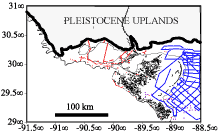 | | Figure 24: Base map showing distribution of onshore and offshore boreholes and seismic profiles. | The stratigraphic framework of the Mississippi River Delta Region has been a topic of investigation for at least five decades (e.g., Fisk, 1944; Fisk and McFarlan, 1955; Frazier, 1967; Boyd et al., 1989; Stanley et al., 1996). Historically, the primary objective of such studies has been, through an analysis of stratigraphic relationships, to decipher Mississippi River depositional history and characterize depositional patterns of approximately the last 25,000 years. One outcome of these studies has been a more complete understanding of how global sea-level fluctuations, driven by Late Quaternary glaciations, influence the location and type of Mississippi River deposition. Moreover, recent suggestions that the Late Quaternary sediment type and thickness influence delta-plain subsidence trends (Kuecher, 1994; Roberts et al., 1994) and thus wetland loss and coastal erosion emphasize the continuing necessity of geologic framework studies. This study correlates onshore to offshore stratigraphic units of the delta plain and continental shelf to more fully elucidate the type and thickness of latest Quaternary sedimentary units within the Lake Pontchartrain Basin. Sediments of primary interest are those that have been deposited since a sea-level low of 110 to 120 m (360.9-393.7 ft.) below modern sea-level approximately 18,000 yrs B.P. during the late Wisconsin glaciation (Fairbanks, 1989). This study builds upon and expands earlier studies by integrating previously developed onshore and offshore stratigraphic data sets with unpublished high-resolution seismic profiles. Several hundred boreholes, hundreds of kilometers of high-resolution seismic profiles and numerous published cross sections spanning fifty years of research constitute the database (Figure 24). Discussion During the late Wisconsin sea-level low, drainage systems entering the northern Gulf rim extended across the exposed continental shelf and/or incised underlying older sediments (Kindinger, 1988; Sydrow and Roberts, 1996). At maximum withdrawal of the sea, most of the eastern continental shelf was subaerially exposed creating an expanded coastal plain. Erosion and soil-forming processes during this exposure created a sedimentary horizon known as the "Prairie surface" because of suggested landward correlation to the coast-parallel late Pleistocene Prairie Formation (Fisk, 1944). This erosional surface is referred to here as the late Wisconsin unconformity. Across much of the shelf, the late Wisconsin unconformity is seismically imaged as the uppermost traceable surface that truncates underlying sedimentary units. Borehole data provides independent verification of the unconformity. As the late Wisconsin glaciers melted and released water to the ocean basins, the continental shelf was transgressed by marine waters. A transgressive sand-rich sedimentary layer deposited at the edge of a northward progressing shoreline provides evidence in the sedimentary record for this marine incursion. From the Modern Delta to New Orleans, the transgressive layer, recognized in lithologic and seismic data and identified in numerous stratigraphic cross sections (Frazier, 1974; Autin et al., 1991), consists of shell-rich, sandy and silty sediment. This transgressive layer exists as a locally continuous "sheet" or infills local topography of the underlying unconformity. Fine-grained, shell-rich transgressive sediment below the Modern Delta trends northward into sandier and more silt-rich sediment, terminating northward as shell and mud-rich sediment at a mid-Holocene, beach/barrier sand (Pine lsland Beach Trend) in the vicinity of New Orleans (Saucier, 1994). Radiocarbon-dated shells within the layer below the Modern delta indicate a maximum age of 15,500 yrs B.P. (Morgan et al., 1963), whereas dates from the the Pine Island Beach Trend range from 5,500 to 6,000 yrs B.P (Saucier, 1963). Generally, finer grained sediments overlying the transgressive layer and late Wisconsin unconformity indicate the increasingly greater influence of marine, deltaic and low-gradient riverine deposition on the continental shelf as sea-level rose. Fisk (1944) referred to this predominantly fine-grained unit above the late Wisconsin unconformity as topstratum. Thus, the topstratum interval represents a significant change in depositional style related to sea-level rise following the late Wisconsin sea-level low. In this study the late Wisconsin unconformity and/or the transgressive marine layer have been used to isolate and identify much of the topstratum lithosome that was deposited concomitant with and subsequent to this sea-level low. Stratigraphic boundaries of the topstratum lithosome are contacts representing time-transgressive deposition. Within the LPB, the topstratum lithosome is primarily a result of seaward progradation of the St. Bernard and Plaquemine-Modern delta lobes within approximately the last 6,000 years (Frazier, 1967). River avulsions, perhaps related to "megafloods" through the Mississippi River drainage (Brown et al., 1999), resulted in successive development in the study area of the St. Bernard, Plaquemines and Modern delta complexes (Frazier, 1967). Except for the shelf-edge Modern delta, the deltas have been termed shoal or shelf-phase deltas (Fisk, 1944) because of their thin (generally less than 50 m (164.0 ft.)), widespread distribution related to progradation into shallow, shelf waters. 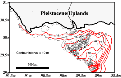 | | Figure 25: Isopach map of the Topstratum Lithosome. | 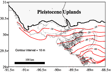 | | Figure 26: Structural contour map for base of Topstratum Lithosome. | Figure 25 is an isopach (thickness) map of the topstratum lithosome. The most obvious feature of the contour map is the thickness of the topstratum lithosome across the delta plain and continental shelf adjacent to the subaerial delta plain. Distribution of the topstratum closely parallels the distribution of Holocene deltaic lobes. However, because relative sea-level rise across early Holocene deltaic deposits originally extending onto the shelf resulted in marine transgression and redistribution of these sediments, the original thickness of the deltas is not preserved. Had the pre-modern deltas not been submerged, a thicker topstratum lithosome would likely extend farther seaward. However, because marine processes have redistributed portions of the topstratum lithosome, the subaerial delta plain is where most of the thick topstratum is preserved. A relatively thick topstratum interval of slightly more than 120 m (393.7 ft.) exists in the vicinity of the current Balize depocenter where deposition by the Mississippi River has been concentrated during the last 1,000 years. A structure contour map on the base of the topstratum lithosome is shown in Figure 26. The structural configuration closely parallels the modern bathymetric profile of the area; seaward dip is approximately 1.0 m/km (5.28 ft/mi.). Additionally, the structural-contour map indicates a slight depression at the topstratum base below the Modern delta that may be related to local subsidence caused by the overlying topstratum thickness. « Previous | Next » |
