| |  |  | | Lake Pontchartrain Atlas: | |  | | |  | | |  | | |  | | |  | | |  | | |  | | Physical Environments |  | |  | | |  | | |  | | |  | | |  | | |  | | |  |  | |  | |  | | |  |  |  | | | |  | Physical Environments - Relative Sea Level Rise Contributors: Britsch - Regional Long Term Relative Sea Level Rise Rates Derived from Radiocarbon Dating of Buried Peat Deposits
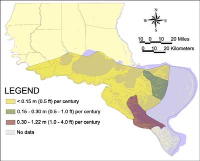
The U.S. Army Corps of Engineers, New Orleans District (USACE-NO) maintains a database of long-term (greater than 100 years) relative sea-level rise rates for the Louisiana coastal zone (Figure 74). These rates are derived from radiocarbon dating of buried peat deposits representing marsh surfaces that were once at or near sea level. The subsidence rate is determined from the depth-versus-age relationship of the peat sample. The relative sea-level rise rate map of the LPB was compiled by contouring more than 100 individual rates throughout the Basin. The map illustrates the general regional variability in the relative sea-level rise rates as interpreted from site specific rates. Relative sea-level rise rates at any given location within the Basin can vary widely, both higher or lower, depending on many natural and anthropogenic factors.  | | Figure 74: USACE -NO map of sea-level rise rates for the LPB. Click on the image for a larger version. | « Previous | Next » |

