| |  |  | | Lake Pontchartrain Atlas: | | | | | | | | | | | | | | | | | | | | | | Physical Environments |  | | | | | | | | | | | | | | | | | | | | | | |  | | | | | | | | | | |  | Physical Environments - Wave Climate Contributors: List, Signell 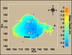 | | Figure 49: Water depth and instrument location. | The orbital currents associated with waves generated by local winds are likely to be a primary mechanism of bottom sediment resuspension within the Lake Pontchartrain Basin. To better understand the resuspension potential throughout the Basin, the numerical wave-prediction model, Hindcasting Shallow Water Waves (HISWA) was used to simulate the patterns of bottom orbital currents. The model estimated long-term sediment resuspension potential by generating wave simulations at a wide range of wind speeds and directions. These predictions were then weighted with long-term wind observations. Figure 49 shows the location of time-series instruments and water depth. HISWA is a steady-state wave model that computes wave heights on a rectangular grid over complex topography. HISWA includes the simultaneous effects of wave generation by wind, wave propagation including shoaling and refraction and wave dissipation through bottom friction and breaking. The model follows a semi-directional spectrum scheme in which waves are divided into a series of directional bins, each with an assumed distribution of wave energy characterized by a significant wave height and mean period. Although wave energy can freely transfer from one directional bin to another through refraction, the energy of waves refracting beyond the model's directional limits is lost from the model, an effect referred to as energy leakage. 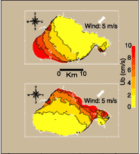 | | Figure 50: Model-predicted bottom velocity with 5m/s wind speed from the northeast (top) and southwest (bottom). | For this study, default HISWA parameters were used in all cases. A square computational grid was constructed with dimensions 90 x 90 km (56 x 56 mi) and grid spacing of 200 m (~219 yd) in the wind direction, 400 m (~438 yd) perpendicular to the wind direction, and a directional spread of 120 degrees with directional bins of 10 degrees. This grid was centered on Lake Pontchartrain, allowing prediction of waves generated by wind from all points of the compass. Predicted wave heights were generated entirely within HISWA through wind stress, without the need for an incoming wave boundary condition. We computed 128 HISWA simulations of the near-bottom wave orbital velocity maximum, Ub, for winds of 2.5, 5.0, 7.5, 10.0, 12.5, 15.0, 17.5 and 20.0 meters per second (m/s), each at 16 directions equally spaced around the compass. Examples of Ub predictions are given in Figure 50 for winds of 5 m/s from the northeast and 5 m/s from the southwest. The corresponding wave heights predicted by the model are shown in Figure 51. These examples demonstrate the importance of wind direction and fetch in controlling the distribution of orbital velocities within the Basin. Specifically, sediment resuspension is driven by wind speed and direction. 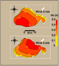 | | Figure 51: Model-predicted significant wave height with a 5m/s wind speed from the northeast (top) and southwest (bottom). | Although the model simulations predicts the Basin's wave response for a wide range of conditions, clearly some conditions are more common that others and should have a stronger influence on the long-term potential for sediment-resuspension in the Basin. Figure 52 shows the distribution of wind speeds and directions for wind observations taken hourly at New Orleans Airport between September 1, 1991 and September 1, 1994. Winds from the northeast and southeast are prevalent as indicated by the dark red colors in those quadrants, with relatively few observations from the northwest. With the assumption that the wind distribution in Figure 52 is representative of the winds over Lake Pontchartrain, the set of 128 model simulations of bottom orbital velocity were weighted with the wind distribution to give a long-term estimate of the potential for Ub magnitude throughout the Basin. These results are presented in terms of the percent of time that Ub is expected to exceed certain values thought to represent the threshold for the initiation of sediment resuspension. An example is given in Figure 53 for thresholds of 15 and 20 centimeters per second (cm/s) (5.9 and 7.9 in/sec), approximately the current magnitude needed for resuspension of fine sand and silt-sized sediment. As a result of the prevalence of winds from the northeast through southeast, the percent of time that Ub exceeds the threshold values is greatest in the western portion of the Basin. The least impacted portions are in the deeper regions of the east-central Basin (as indicated by the dark red and orange colors) and in a small area in the far eastern portion of the Basin. Several modeling limitations may significantly influence the patterns shown in Figures 50, 51 and 53. Energy leakage occurs with waves refracting more than 60 degrees away from the primary wind/wave propagation direction because of the 120-degree directional spread used. Thus waves and their associated bottom orbital velocities will be artificially low along portions of coast that are parallel to the wind direction. However, due to the short-period, locally generated nature of the modeled waves, strong refraction of waves away from the primary travel direction will occur only very close to shore. Thus, the majority of the Basin should be unaffected by the leakage problem. 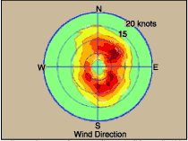 | | Figure 52: New Orleans wind counts (1981-1995). The colors denote frequency from low (green) to high (red). | Another problem is the model's assumption of steady-state conditions. In the model, fully developed sea state is predicted for every wind condition regardless of how rapidly the wind speed or direction might change in nature. The error induced by this assumption, as well as HISWA's overall ability to model wave in the Basin, will be evaluated by comparing the model results with 1995 field observations. However, because of the restricted nature of the Basin, the response of Ub to changing wind conditions is expected to be very rapid. Also, the long-term averaging used to generate these results are expected to cancel out problems with non-steady conditions, unless it can be shown that a particular wind condition in the observational record is less steady than others. Further analysis of wind data will be necessary to identify such biases. Due to the model limitations and assumptions the results presented in Figure 53 must be viewed as a very generalized guide to regions of the Basin that are more likely to experience sediment resuspension. However, combined with results from circulation modeling during individual resuspension events, this information can help explain the lakebed's sediment-type distribution, and improve our understanding of the sources, transport pathways and sinks of the Lake's bottom sediments. The results shown in Figure 53 can also be used as a guide to the disposal of sediments such as dredge material so they are least likely to be transported out of their disposal site. 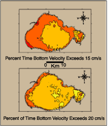 | | Figure 53: Prediction of long-term probity impact distribution. Low percents are indicated by yellows and higher percents are orange and red colors. | Further work will include the analysis of a 10-year observational record to provide a better long-term characterization of Lake Pontchartrain winds. The New Orleans Airport wind data will be evaluated for its suitability for representing Lake Pontchartrain winds and solving the problems associated with HISWA's assumption of steady-state conditions. HISWA model predictions at point locations will be tested against recently collected field data to provide an overall assessment of HISWA's ability to predict Basin waves using New Orleans airport winds. Predictions of the long-term bottom orbital impact distribution (Figure 53) will be compared with measurements of the Lake's surficial sediment-type distribution to evaluate the degree to which wave orbital motions control the Lake's bottom sediment distribution. Sediment resuspension and transport for particular wind events will be studied through a combination of wave modeling using HISWA, circulation modeling using the estuarine, Coastal and Ocean Model (ECOM-si), and satellite observations. « Previous | Next » |
