| |  |  | | Lake Pontchartrain Atlas: | | | | | | | | | | | | | | | | | | | | | | Physical Environments |  | | | | | | | | | | | | | | | | | | | | | | |  | | | | | | | | | | |  | Physical Environments - Hurricane History Contributors: Yamazaki, Penland As a result of its elevation near sea level, the Lake Pontchartrain Basin is quite vulnerable to tropical storms and hurricanes. Hurricanes are categorized by their windspeed in miles per hour (mph) (Table 4). Hurricanes have affected the Louisiana coastline with a frequency that peaks in September (Tables 5, 6). Hurricanes with significant monetary or human loss are memorialized by retiring their name (Table 8). The city of New Orleans averages 1.8 m (6 ft) below sea level, resembling a shallow depression surrounded by levees and water. The levee system in New Orleans is one of the most extensive in the world, but it is designed for a Category 3 hurricane maximum. Furthermore, storm vulnerability is made worse by ongoing wetland loss and barrier island erosion. The Basin is home to more than one million people and is extremely important to the vitality of the Gulf of Mexico ecosystem. For these and many other reasons, it is important to study past tropical storm events so that we can be better prepared for future events. The four storms in the figure below represent some of the most devastating, and therefore some of the most studied storms, in the Lake Pontchartrain Basin during the Twentieth Century.  | 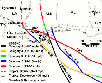 | | Figure 25: Hurricanes 1947, Betsy, Camille and Georges | | Hurricane of 1947 (September 04-21, 1947) | | The 1947 Hurricane made landfall near the Chandeleur Islands, LA on September 19, 1947. Wind gusts of 112 mph and a central pressure of 967 millibars (mb) were measured at Moisant International Airport. A storm surge of 3.0 m (9.8 ft) reached Shell Beach, Lake Borgne. Moisant Airport fields were under 0.6 m (2 ft) of water while Jefferson Parish was flooded to depths of 1.0 m (3.28 ft). New Orleans suffered $100 million in damages. Total loss of life was 51 persons. As a result of this storm, hurricane protection levees were built along the south shore of Lake Pontchartrain to protect Orleans and Jefferson Parishes from future storm surges. | | Hurricane Betsy (August 08-27, 1965) | | Betsy was a fast moving storm (22 mph forward speed) that made landfall at Grand Isle, LA on September 10, 1965. The central pressure at landfall was 948 mb. Grand Isle experienced 160 mph gusts and a 4.8 m (15.7 ft) storm surge that flooded the entire island. Winds gusted to 125 mph in New Orleans with a 3.0 m (9.8 ft) storm surge that caused the worst flooding in decades. Winds reached 100 mph over most of southeast Louisiana and exceeded 60 mph as far inland as Monroe, LA. Offshore oil rigs, public utilities, and commercial boats all suffered severe damage. Loss of life from Betsy was a total of 81 persons, with 58 in the state of Louisiana. Damage in Southeast Louisiana totaled $1.4 billion. The Orleans Levee Board raised the existing levee to a height of 12 ft in response to the flooding caused by Betsy. | | Hurricane Camille (August 14-22, 1969) | | Camille intensified rapidly in the Gulf of Mexico, reaching Category 5 status by August 16. The small-diameter hurricane headed NE at 14 mph and made landfall in a sparsely populated section of the Mississippi coast on August 17. Wind estimates during landfall reached 175 mph. Atmospheric pressure at landfall was 901 millibars, second only to the Labor Day Hurricane of 1935 (892 millibars) as the most powerful storm ever to reach the U.S. coast. The storm surge generated by Camille flooded areas from lower Plaquemines Parish, LA to Perdido Pass, AL. The storm surge exceeded 24 ft in Pass Christian, MS. A 4.6 m (15 ft) storm surge inundated Boothville, LA. Storm surge reached 2.7 m (9 ft) in the Rigolets and 1.4 m (4.6 ft) in Mandeville, LA. The confirmed U.S death total was 258. Louisiana damages totalled $350 million. Structural damage at landfall was near complete. Louisiana damage was severe south of Empire, LA. | | Hurricane Georges (September 15 - October 01, 1998) | | Georges did extensive damage to Haiti, the Dominican Republic, Puerto Rico and other Caribbean islands. Georges made final U.S. landfall near Biloxi, MS on September 28. The maximum sustained surface wind at landfall was 104 mph and the minimum central pressure was 964 mb. Maximum storm surge in Louisiana was 2.7 m (8.9 ft) at Point à la Hache. Maximum surge along the U.S. Gulf Coast was 3.4 m (11 ft) in Pascagoula, MS. Georges severely eroded the Chandeleur Islands which are the first line of storm surge defense for southeast Louisiana and southern Mississippi. Total loss of life was 460 persons, all outside of Louisiana. Dozens of camps not protected by levees were destroyed along the south shore of Lake Pontchartrain. Georges again showed the vulnerability of New Orleans to hurricanes, and efforts resumed the following year to improve the levee system along the canals that connect the city with the Lake. | Source: Hurricane dataset obtained from the National Hurricane Center website. « Previous | Next » |
