1Alaska Division of Geological & Geophysical Surveys
794 University Avenue, Suite 200
Fairbanks, AK 99709
Telephone: (907) 451-5027
Fax: (907) 451-5050
e-mail: Larry_Freeman@dnr.state.ak.us,
Carrie_Browne@dnr.state.ak.us
2GeoNorth, LLC
1000 O'Malley Road, Suite 200
Anchorage, AK 99515
Telephone: (907) 677-1500
Fax: (907) 677-1502
e-mail: kengle@geonorth.com
The database project faces such challenges as serving the needs of multiple users, functioning as part of multiple distributed data networks, anticipating future needs of the database and DGGS, and allowing for flexibility in the design of the database to adapt to changing technology. These challenges will be met using a fully normalized relational database model, developed in a spatial-data-capable, relational database management system. The logical model presented in our poster will be the basis for the development of the DGGS geologic database.
GeoNorth's next step is to convert the logical model to a physical model. Database (structured query language data definition language) code will be generated from the physical database model and a prototype database will be built. We expect that much of this design work and code generation will be performed using ERwin. An initial internal release of the database on the DGGS network is anticipated by summer 2002.
DGGS staff will test the database structure, using command-line interface (Oracle SQL+), ArcGIS 8, Microsoft Access, Map Info, and other third-party products. After the initial testing is complete and DGGS has accepted the database from GeoNorth, we will start building applications to facilitate frequently repeated data entry functions and queries and to allow for public access to the data via the DGGS Web site and through a publicly accessible workstation that will be available at DGGS's office.
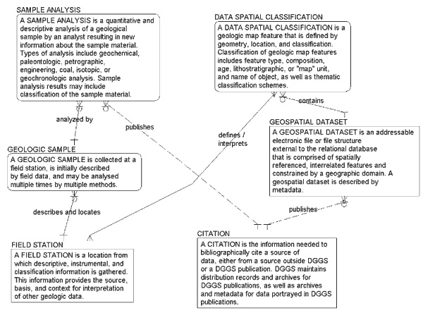
Figure 1. Selected primary entities of the DGGS logical database model. The many-to-many relationship between field data and geologic-map features is defined manually by a geologist and by geographic data manipulation. Because of the diversity and inconsistency in the way that geologic-map features are defined at DGGS, we were not able to logically resolve this relationship. Information Engineering (IE) notation (Halpin, 2000) is used in this diagram and in Figure 2; verbs describing the relationships are read from bottom to top. |
Field station data include descriptive, measured, and instrumental data that are collected in the field to support geologic mapping, resource investigations, and hazard evaluations. At DGGS, all field data are identified and located by a field station. Each field station has a point location and may have an associated geometry, such as a polygon that surrounds an outcrop or geothermal occurrence or the surface trace of a borehole.
Sample analyses consist of instrumental analyses and descriptions of geologic samples. Sample analysis data include summary and secondary analysis information as well as original laboratory data. A large number of the entities in the DGGS logical model are subtypes and descendants of a sample analysis. A sample analysis is identified by the sample number and the analysis batch (who, what, and where).
Publication information is recorded for DGGS publications and for external publications that are cited as sources in the DGGS data. Information for DGGS publications includes information about distribution, electronic files used to make the publications, and the archive location of those publications. A geospatial data set is a set of spatially referenced, interrelated features. They are constrained by a geographic domain and exist as a separately addressable file that can be linked to the relational database that contains the map's descriptive information. All geologic map objects in the DGGS database will be derived from a geospatial data set. Some data sets are distributed by DGGS and others are distributed from other sources and used in the DGGS database. Regardless, metadata for the source data set can be queried from the database and displayed in a format compatible with FGDC-compliant metadata. Metadata for each data set will be required before it is loaded into the database.
A geologic map feature in the DGGS data model (Entity Data Spatial Classification, Figure 2) is defined by geometry and classification attributes. Geologic map features have topologic and geologic relationships that are internally consistent within a geospatial data set, but are related to geologic map features in other geospatial data sets only by their classification attributes. In other words, we are intending to preserve "geologic map edge faults" until they can be resolved. Classification attributes of geologic map features include feature type, composition, geologic age, or map unit (lithostratigraphic) name, proper name (e.g., Denali Fault), and derivative classification themes. Classification attributes are related to cartographic symbols to provide visualization of the features using multiple symbol sets. Although this model deviates from the North American Geologic Map Data Model (Johnson, and others, 1999), it gives us flexibility to create views of geologic map data in multiple configurations. The remaining entities in the database include thematic information such as mineral occurrence information and reference tables for data validation and indexing. The reference tables will contain the standard nomenclature, classification, and keywords that DGGS uses to conduct geologic work.
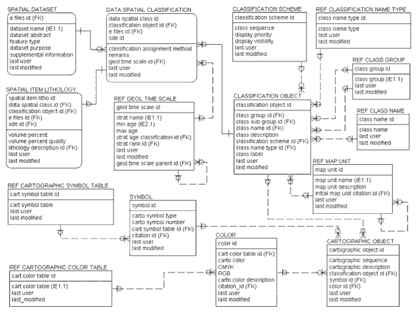
Figure 2. Entity-relationship diagram for geologic-map features in the DGGS logical database model. |
In the next year, DGGS will begin using the database to compile geologic data collected during the 2003 field season. Other DGGS projects with their own data sets will begin connecting to the DGGS database. The database project staff will continue loading data from multiple data sources, and will begin creating custom applications using the database to produce output files for Web pages, publications, and distribution to external databases.
Halpin, T., 2000, Entity relationship modeling from an ORM perspective: Part 3: Journal of Conceptual Modeling, Issue 13, http://inconcept.com/jcm/April2000/halpin.html.
Johnson, B.R., Brodaric, B., Raines, G.L., Hastings, J.T., and Wahl, R., 1999, Digital geologic map model; Version 4.3: Association of American State Geologists/U.S. Geological Survey draft document, 69 p., http://geology.usgs.gov/dm/model/Model43a.pdf.