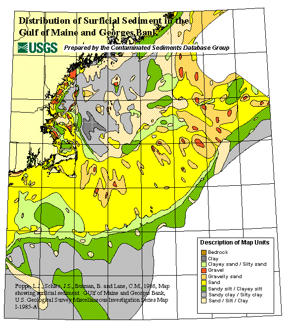
Skip past footer information
USGS Logo with lilnk to USGS Home Page
Contaminated Sediments Database for the Gulf of Maine, OFR 02-403
Poppe, L.J., Schlee, J.S, Butman, B. and Lane, C.M., 1986, Map Showing Surficial Sediment. Gulf of Maine and Georges Bank, U.S. Geological Survey Miscellaneous Investigation Series Map I-1986-A.
ALSO IN: A Marine GIS Library for Massachusetts Bay focusing on disposal sites, contaminated sediments, and sea floor mapping.  Butman, B., and Lindsay, J.A. (eds).  U.S. Geological Survey Open File Report 99-439.  1  CD-ROM.*

Description of Surficial Sediment in the Gulf of Maine and Georges Bank

*Prepared in cooperation with National Oceanic and Atmospheric Administration (NOAA), Science Applications International Corporation (SAIC), Genwest-System Inc., U.S. Environmental Protection Agency (USEPA), U.S. Army Corps of Engineers (USACE), and Massachusetts Water Resources Authority (MWRA).


Skip past navigation information

Home  /  Site Map  /  Introduction  /  Overview  /  Contacts  /  DB Construction  /  Data Access  /  Data Utilization  /  Data Tables & Maps  /  Geographic Context/Links  /  References  /  Collaborators  /  Acknowledgements  /  Disclaimer
Skip past footer information

Department of Interior
> U.S. Geological Survey > Coastal and Marine Geology > Woods Hole Field Center

USGS Privacy Statement / Disclaimer / Accessibility
URL: https://pubsdata.usgs.gov/pubs/of/2002/of02-403/HTMLdocs/1995Schl.htm
Maintained by Eastern Publications Group
Modified Friday, 11-Jan-2013 03:30:25 EST