
Contaminated Sediments Database for the Gulf of Maine, OFR 02-403
Home/Abstract
Site Map
Introduction
Content Overview
How to Reach Us
Database Construction
How to Access
the Data
Data Utilization
Data Tables & Maps
Geographic Context
& Outside Links
References Cited
Collaborators
Acknowledgements
DISCLAIMER
Geographic Context and Outside Links
To take full advantage of the Contaminated Sediments
database, the information provided needs to be looked at in its geographic
context. There are many external parameters which affect the concentrations
of contaminants such as population in a given coastal area, land use,
pollution point sources, and others. Viewing data in geographic
context involves using a Geographic Information System (GIS), a system
of computer hardware, software, and geographic data designed to support
the manipulation, analysis, modeling, and display of spatially referenced
data which can, in turn, be used for solving complex planning and management
problems. Geographic analysis and mapping allows one to see, explore,
and analyze these data by location to reveal hidden patterns, relationships,
and trends that can’t be seen in spreadsheets or statistical packages.
Spatial and attribute information about features
can be stored in two basic data "structures." The vast majority
of the data sets use a vector (line) data structure, while other data
sets, notably satellite imagery and elevation data, use raster (grid-based)
data structures, like a picture on a TV screen. Raster data often represent
phenomena that exhibit a gradual transition in character (e.g., rainfall
or temperature).
Many collections of geographic data have
already been made available on the web, some of which are listed below.
Displays (indicated
by ![]() )
of some of these data are also included. (Disclaimer)
)
of some of these data are also included. (Disclaimer)
![]() Canada
Canada
Fisheries
and Ocean Canada/Marine Contaminants Research
Atlantic
Coastal Zone Information Steering Committee (ACZISC)
![]() Maine
Maine
Directory
of Gulf of Maine Geographic Data (by Maine GIS)
Maine Department of Marine Resources
Maine State Planning
Office: Maine Coastal Program![]() Massachusetts
Massachusetts
Directory
and Links for State GIS Resources
Massachusetts GIS Digital orthophotos
of Boston Harbor
Massachusetts Office
of Coastal Zone Management
![]() New
Hampshire
New
Hampshire
New Hampshire Office
of State Planning
![]() Shorelines
and Bathymetry
Shorelines
and Bathymetry
General
Bathymetric Chart of the Oceans Bathymetry Extractor
National Oceanic
and Atmospheric Administration/ National Oceanic Service (NOAA/NOS)
Medium Resolution Coastline 1:70,000)
![]() Gulf
of Maine
Gulf
of Maine
Gulf of Maine
Council on the Marine Environment
Gulf of Maine Information
System
Regional
Association for Research on the Gulf of Maine (RARGOM)
![]() Sources
of Contamination
Sources
of Contamination
![]() Locations
of active and inactive CSO's and outfalls - Massachusetts
Water Resources Authority (MWRA)
Locations
of active and inactive CSO's and outfalls - Massachusetts
Water Resources Authority (MWRA)
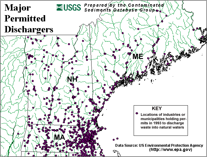
Major Permitted Dischargers - United
States Environmental Protection Agency (USEPA)
Pollution Point Sources - NOAA/NOS
![]() Sedimentary
Environments
Sedimentary
Environments
![]() Boston
Harbor and Cape Cod Sound
Boston
Harbor and Cape Cod Sound
![]() Gulf
of Maine Coast
Gulf
of Maine Coast
![]() Surficial
Sediments in the Gulf of Maine and Georges Bank
Surficial
Sediments in the Gulf of Maine and Georges Bank
![]() Marine
Habitats
Marine
Habitats
USEPA
National Estuary Program
Stellwagen
Bank Information System![]() Population
Population
US POP80, ![]() USPOP90
- U.S. Geological
Survey (USGS), Water Resources
USPOP90
- U.S. Geological
Survey (USGS), Water Resources
U.S. Census Bureau
Population:
Distribution, Density and Growth
![]() Land
and Watershed Characterization
Land
and Watershed Characterization
![]() Annual
Runoff - USGS,
Water Resources
Annual
Runoff - USGS,
Water Resources
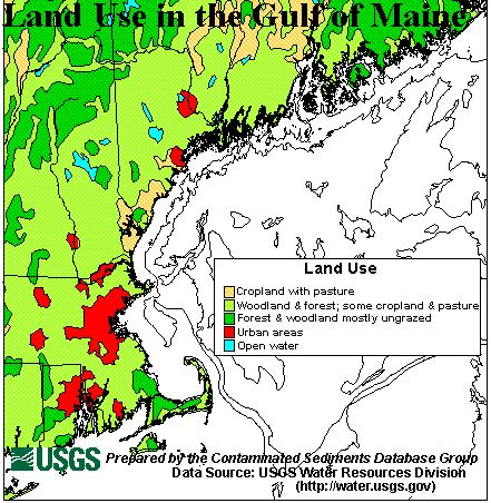
![]() Major
land uses - USGS,
Water Resources
Major
land uses - USGS,
Water Resources
Streams
USEPA Region
1 Watersheds
![]() Gulf
of Maine Watersheds - NOAA/NOS
Gulf
of Maine Watersheds - NOAA/NOS
Rivers
![]() Sources
of Additional Information
Sources
of Additional Information
Dartmouth
Circulation Models for the Gulf of Maine and Georges Bank
Ecology
and Oceanography of Harmful Algal Blooms (ECOHAB)
European Geological Data Catalogue
(Geixs)
European Directory
of Marine Environmental Data (EDMED)
Geospatial Data
Clearing House
Geological
Survey of Canada (Atlantic) Sample Inventory Database (SID)
Lamont-Doherty Deep-Sea Sample
Repository
Land
Use and Land Cover
NGDC Index
to Marine Geological Samples
NOAA
National Status and Trends Program
NOAA
State of the Coast Reports - Sediment Toxicity
PANGAEA Network for Geological and Environmental
Data
Scripps Institution of Oceanography
Sea-Search
U.S. Army Corps of Engineers, New England Division
U.S. Coast Guard, First
District
USGS East Coast Sediment Texture Database
U.S.
Environmental Protection Agency (USEPA) Region 1
USEPA - National Contaminated Sediment
Management Strategy and Newsletter
U.S. Fish and Wildlife Service
Gulf of Maine Coastal Program
Waterways Experiment Station (WES)
Environmental Laboratory