
Contaminated Sediments Database for the Gulf of Maine, OFR 02-403
Home/Abstract
Site Map
Introduction
Content Overview
How to Reach Us
Database Construction
How to Access
the Data
Data Utilization
Data Tables & Maps
Geographic Context
& Outside Links
References Cited
Collaborators
Acknowledgements
DISCLAIMER
TEXTURE PLOTS AND GRAPHS
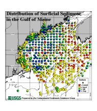
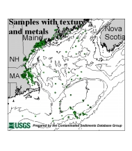
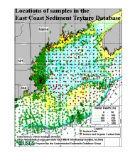
The following maps show pie chart displays of the texture data from the entire Gulf of Maine as well as close-ups of Boston Harbor, Great Bay, Casco Bay, and Penobscot Bay. There is also a figure which shows all the texture data included in the USGS East Coast Sediment Texture database. Those samples from this database which have other contaminant data associated with them (for instance those samples which contain Total Organic Carbon) are included in the Contaminated Sediments Database.
|
|
|
|
| Gulf
of Maine (39KB) |
Samples
with texture and metals (25 KB) |
USGS
East Coast Sediment Texture Database (63 KB) |
Download/view the Table of Texture
Information
File Name: TXTR2002.xls (Microsoft
Excel 5.0/95)
File Size: 2358 KB
File Name: TXTR2002.txt
(Tab Delimited Text)
File Size: 1569 KB