
|
|
|
Archive of Boomer Seismic Reflection Data
Collected during USGS Cruise 97KEY01
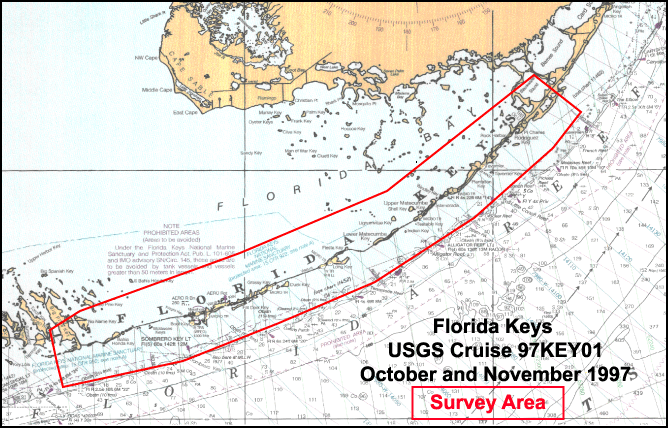
Upper and Middle Florida Keys
12 October - 1 November, 1997
U.S. Geological Survey Open-File Report 02-421
This Digital Versatile Disc (DVD) Open-File Report serves as an archive of field seismic data, associated navigation files, trackline maps, scanned logbooks, and formal seismic metadata collected on USGS Cruise 97KEY01. A Compact Disc Read Only Memory (CD-ROM) included with this report, contains GIS information for use with ESRI's GIS software ArcView3.x (UNIX/WINDOWS), ArcGIS 8.1 (WINDOWS) and ArcExplorer 2.0 and Java Edition 4.0.
This data was recorded aboard the Charter Research Vessel, Captain's Lady along the Florida Keys, just north of Molasses Reef off north Key Largo (Upper Keys) to the east boundary of Looe Key National Marine Sanctuary (Lower Keys). The dates of operation were October 12 to November 1, 1997.
31 Tracklines were collected and recorded. Detailed maps are provided in this report, along with JPG and GIF images of the seismic profiles.
Note: The web version of this archive does not contain the GIS files or the SEG-Y Trace files. These files are very large and would require extremely long download times. To obtain the complete DVD and CD-ROM archive, contact USGS Information at (888) ASK-USGS.
| README | TRACKLINE MAPS | |||
| CRUISE ACTIVITY INFORMATION | ||||
| SEISMIC UNIX SCRIPTS | NAVIGATION DATA | |||
| USGS SOFTWARE | ||||
| SEISMIC DATA | ||||
| DISCLAIMER | ||||