
![]()
Wisconsin Bouguer Gravity Anomaly Map
![]()
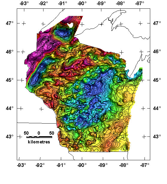
The State of Wisconsin has excellent gravity coverage, made possible by its rectilinear network of roads. The map is preliminary because several completed surveys in the southeast part of the state have yet to be processed. The present preliminary Bouguer gravity anomaly grid for the state of Wisconsin was compiled using data from 37,529 gravity stations from 12 sources. Data north of 44 degrees latitude come mostly from Ervin and Thompson, (1991a, 1991b) and Ervin (1991, 1993, 1996). Most stations south of 44 degrees are from Geister (USGS, unpublished), Aiken and others (1983), and an unpublished Masters thesis (Brukardt, 1983; Sverdrup and others, 1997; written communication by William Kean, University of Wisconsin, Milwaukee, 2001) . The station locations for the 12 surveys are shown in a station index map.
Observed gravity values, relative to the IGSN-71 datum, were reduced to the Bouguer anomaly using the 1967 gravity formula and a reduction density of 2.67 g/cc. The data were converted to a 1-km grid using minimum curvature techniques. The preliminary Bouguer anomaly grid for the above map may be downloaded. This project was supported by the Mineral Resources Program of the USGS.
|| Wisconsin Mag Page || USGS - Eastern Minerals Team || USGS - Geology || USGS - Home Page || References ||