|
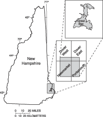
| Figure 1. Location of the lineament and outcrop study area in the Dover West, Dover East, Newmarket, and Portsmouth 1:24,000-scale quadrangles in southeastern New Hampshire. |
Great Bay is an estuary in southeastern New Hampshire (fig. 1, plate 1(1.6 MB, pdf)) in the 1:24,000-scale Dover West, Dover East, Newmarket, and Portsmouth, 7.5-minute quadrangles. The U.S. Geological Survey (USGS), in cooperation with the Civil Engineering Department at the University of New Hampshire, the Cooperative Institute for Coastal and Estuarine Environmental Technology, and the U.S. Environmental Protection Agency, is assessing ground-water flow to Great Bay. A better understanding of the ground-water-flow system is necessary to identify and locate potential sources of nutrient loading to the bay by ground-water discharge. Identification of fracture-correlated lineaments may indicate bedrock-fracture zones that could serve as ground-water-flow paths and potential points of discharge to the bay. Certain types of fracture-correlated lineaments have been correlated with high bedrock well yields in fractured-bedrock aquifers (Moore and others, in press).
This report describes the results of a lineament study and outcrop-fracture investigation of the bedrock along the shore of Great Bay and adjacent areas. Lineament-identification techniques used in the study are well documented by Brown (1961), Clark and others (1996), and Lattman (1958). Additional references on this topic are included at the end of this report. Lineament and fracture data are correlated to indicate potential discrete zones of fracturing in the bedrock (referred to as fracture zones in this report), which may serve as ground-water-flow paths. Ground-water flow in bedrock fractures may be more readily identified where permeable surficial aquifers are thin or absent, such as the western shore of Great Bay. The extent of the study area is the perimeter of Great Bay and the immediately adjacent areas.
Previous studies identifying fracture-correlated lineaments in the northeastern U.S. include those by Walsh (2000), Moore and others (in press), and Mabee and others (1994). Walsh found that 24 percent of lineaments near outcrops correlate with brittle structures including joints, fracture zones, and faults in Windham, N.H. Moore and others (in press) statistically identified specific types of fracture-correlated lineaments that were related to high-yielding bedrock wells in the Pinardville and Windham quadrangles, New Hampshire. Mabee and others (1994) identified 3 percent of lineaments as fracture correlated in a similar setting on Georgetown Island, Maine, and noted that nearby bedrock wells generally had high transmissivities.
Physiographic settings in the study area range from marshlands to hills. Over the region, elevations range from 0 to 85 m. Bedrock is exposed at numerous locations along the west shore of Great Bay between the mouth of the Oyster and Lamprey Rivers and along the east shore of Furber Strait from the headlands near Welsh Cove to Woodman Point (plate 1(1.6 MB, pdf)). The south shoreline, from Weeks Point westward for 2 km, also has a considerable number of bedrock outcrops (plate 1(1.6 MB, pdf)).
Crystalline metamorphic and igneous bedrock geology in the study area is shown on plate 1(1.6 MB, pdf). The bedrock outcrops on the west side of the bay are primarily the Silurian-Ordovician Kittery Formation. The Silurian-Ordovician Eliot Formation crops out along the east and south side of the bay. The contact between the two metasedimentary formations is mapped through the bay from the mouth of the Squamscott River in the southwestern corner, across Fox Point and the west edge of Hen Island in the northeastern corner of the bay (Novotny, 1968, Lyons and others, 1997). Devonian Exeter Diorite is exposed in a few outcrops along the west shore of the bay, and is the dominant rock type inland from the shoreline. The contact between the Exeter Diorite and the Kittery Formation is approximately parallel to the shoreline on the west side of the bay (Novotny, 1968).
Unconsolidated glacial, glaciofluvial, and marine sediments generally cover bedrock in the study area. Most of the west side of the bay is covered by unsorted to poorly sorted glacial till (Delcore and Koteff, 1989) that generally ranges in thickness from 0 to 5 m (Bradley, 1964). Stratified sand and gravel overlies bedrock or till on the east side of the bay.
The extent or distribution of till beneath the stratified sand and gravel is not known. The thickness of stratified drift inland to the east side of the bay ranges from 0 to 18 m (Stekl and Flanagan, 1992).
The authors thank Gregory Walsh and Richard Bridge Moore, U.S. Geological Survey, for providing thorough and constructive colleague reviews of the report. Their reviews improved the conclusions on the nature and occurrence of fracture-correlated lineaments and helped create a more useful, and legible map. Appreciation is expressed to the cooperators from the University of New Hampshire's Civil Engineering Department for providing logistical support for the data collection.
Next: Methods
Previous: Abstract
Table of Contents
| AccessibilityFOIAPrivacyPolicies and Notices | |
 |
|