Organization of the GIS Map Archive |
|||
Sites Database |
|||
| Sites Database: The GIS surface effects sites database contains information about boreholes, detonations, and surface effects maps. The database is provided in both ArcGIS (v. 8.2) geodatabase format and ArcView (v. 3.2) shapefile format as a point coverage. The database is used for information storage and to map the locations of detonation sites on surface effects maps. View a map of the detonation sites | |||
Surface Effects Maps |
|||
|
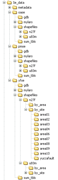
Surface
Effects Maps: The GIS surface effects maps are organized by testing area
within the primary, "Se_data" root-level folder. Metadata files are
provided. The organization of the map archive is illustrated by the
folder tree at left. The three testing area are listed below. View
a map of the testing areas
For each testing area, subfolders contain the ArcGIS (v. 8.2) geodatabase maps (gdb); the original surface effects maps (mylars); and the ArcView (v. 3.2) shapefile maps (shapefiles). Summary attribute tables are also provided (sum_tbls). For more information, view the documentation listing the contents of the Yucca Flat or Pahute Mesa shapefiles folders and the section on Viewing the Original (Mylar) Maps in How to Use These Map Data. Geodatabase Format: Surface effects maps in ArcGIS (v. 8.2) geodatabase format are fully contained within three composite geodatabase files--one for each testing area (oase, pmse, and yfse). On-the-fly projection changes and ArcMap group layer files provide full flexibility to view these maps at any projection by testing area, operational area, or individual site. For more information on how to use these surface effects map data in geodatabase format, see Geodatabase Approach. Shapefile Format: Surface effects maps in ArcView (v. 3.2) shapefile format are stored in the archive by two map projections (n27f and u83m) and three composition levels (testing area, operational area, and borehole site). In the yfse section of the archive, for example, the n27f folder (shown expanded at left) contains shapefiles in Nevada State Plane, NAD27, in feet, while the u83m folder contains shapefiles in Universal Transverse Mercator, NAD83, in meters. For each projection, shapefiles are stored in three map composition levels: (1) NTS testing area composite themes, (2) NTS operational area composite themes (by_area), and (3) detonation (borehole) site themes (by_site); the latter organized in folders named for the NTS Operation Area (for example, area01, area02, etc.). Shapefiles for the oase and pmse testing areas are similarly organized. For more information on how to use these surface effects map data in shapefile format, see Shapefile Approach.
| ||