|
| U.S. Geological Survey Open-File Report 03-001 |
|
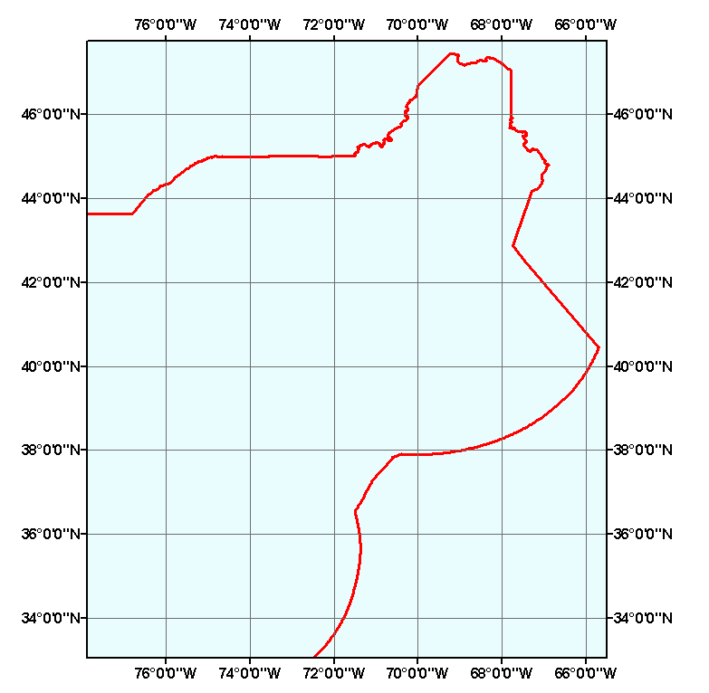
USEEZ-CLIP: Boundaries of the Exclusive Economic Zones of the U.S. for the Gulf of Maine surficial sediment GIS project area. |
Metadata also available as: FAQ - TEXT
The EEZ consists of those areas adjoining the territorial sea of the U.S., the Commonwealth of Puerto Rico, the commonwealth of the Northern Mariana Islands, and U.S. overseas territories and pssessions. The EEZ extends up to 200 nautical miles (370 km) from the U.S. coastline. About 15 percent of this area lies on the geologic continental shelf and is shallower than 200 meters. Within its EEZ, the U.S. has sovereign rights over all living and non-living resources. Other nations may exercise freedom of vessel navigation and overflight within the U.S. EEZ (Source: Year of the Ocean Discussion Papers 1998; 2nd Ed. of Coastal and Ocean Law by Kalo et al. 1994).
The following is provided verbatum from the Federal Register: [Federal Register: August 23, 1995 (Volume 60, Number 163)][Notices][Page 43825-43829]
From the Federal Register Online via GPO Access [wais.access.gpo.gov][DOCID:fr23au95 113]DEPARTMENT OF STATE[Public Notice 2237] Exclusive Economic Zone and Maritime Boundaries; Notice of Limits By Presidential Proclamation No. 5030 made on March 10, 1983, the United States established an exclusive economic zone, the outer limit of which is a line drawn in such a manner that each point on it is 200 nautical miles from the baseline from which the breadth of the territorial sea is measured. The Government of the United States of America has been, is, and will be, engaged in consultations and negotiations with governments of neighboring countries concerning the delimitation of areas subject to the respective jurisdiction of the United States and of these countries. The limits of the exclusive economic zone of the United States as set forth below are intended to be without prejudice to any negotiations with these countries or to any positions which may have been or may be adopted respecting the limits of maritime jurisdiction in such areas. Further, the limits of the exclusive economic zone set forth below are without prejudice to the outer limit of the continental shelf of the United States where that shelf extends beyond 200 nautical miles from the baseline in accordance with international law. The following notices have been published which have defined the United States maritime boundaries and fishery conservation zone established March 1, 1977: Public Notice 506, Federal Register, Vol.41, No. 214, November 4, 1976, 48619-20; Public Notice 526, Federal Register, Vol. 42, No. 44, March 7, 1977, 12937-40; Public Notice 544, Federal Register, Vol. 42, No. 92, May 12, 1977, 24134; Public Notice 4710-01, Federal Register, Vol. 43, No. 7, January 11, 1978, 1658; Public Notice 585, Federal Register, Vol. 43, No. 7, January 11, 1978,1659; Public Notice 910, Federal Register, Vol. 49, No. 155, August 9,1984, 31973. This Public Notice supersedes all limits defined in the above Public Notices. Therefore, the Department of State on behalf of the Government of the United States hereby announces the limits of the exclusive economic zone of the United States of America, within which the United States will exercise its sovereign rights and jurisdiction as permitted under international law, pending the establishment of permanent maritime boundaries by mutual agreement in those cases where a boundary is necessary and has not already been agreed. Publication of a notice on this subject which is effective immediately upon publication is necessary to effectively exercise the foreign affairs responsibility of the Department of State. (See Title 5U.S.C. 553 (a)(1)(B).)
Dated: August 10, 1995. David A. Colson, Deputy Assistant Secretary for Oceans [FR Doc. 95-20794 Filed 8-22-95; 8:45 am] BILLING CODE 4710-09-M
OFR03-001 Home | Introduction | Nomenclature | Browse Maps | Data Catalog | Data Dictionary