              |
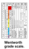 Nomenclature describing size distributions is important to geologists because grain size is the most basic attribute of sediments. Traditionally, geologists have divided sediments into four size fractions that include gravel, sand, silt, and clay, and classified these sediments based on ratios of the various proportions of the fractions. Definitions of the fractions have long been standardized to the grade scale described by Wentworth
(1922), and the size data compiled in this report conform to these definitions. Specifically, according to the
Wentworth grade scale (PDF version) gravel-sized particles have a nominal diameter of
2.0 mm; sand-sized particles have nominal diameters from <2.0 mm to
>62.5
µm; silt-sized particles have nominal diameters from <62.5
µm; to >4.0
µm; and clay is < 4.0µm;.
Nomenclature describing size distributions is important to geologists because grain size is the most basic attribute of sediments. Traditionally, geologists have divided sediments into four size fractions that include gravel, sand, silt, and clay, and classified these sediments based on ratios of the various proportions of the fractions. Definitions of the fractions have long been standardized to the grade scale described by Wentworth
(1922), and the size data compiled in this report conform to these definitions. Specifically, according to the
Wentworth grade scale (PDF version) gravel-sized particles have a nominal diameter of
2.0 mm; sand-sized particles have nominal diameters from <2.0 mm to
>62.5
µm; silt-sized particles have nominal diameters from <62.5
µm; to >4.0
µm; and clay is < 4.0µm;.
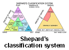 Although several classification schemes have been adopted to describe the approximate relationship between the size fractions, most sedimentologists use one of the systems described either by Shepard
(1954) or Folk (1954,
1974). The original scheme devised by Shepard
(1954) utilized a single ternary diagram with sand, silt, and clay in the corners to graphically show the relative proportions among these three grades within a sample. This scheme, however, does not allow for sediments with significant amounts of gravel. Therefore,
Shepard's classification scheme was subsequently modified by the addition of a second ternary diagram to account for the gravel fraction (Schlee,
1973). The system devised by Folk (1954,
1974) is also based on two triangular diagrams, but it has 21 major categories, and uses the term mud (defined as silt plus clay). The patterns within the triangles of both systems differ, as does the emphasis placed on gravel. For example, in the system described by Shepard, gravelly sediments have more than 10% gravel; in Folk's system, slightly gravelly sediments have as little as 0.01% gravel.
Folk's classification
Although several classification schemes have been adopted to describe the approximate relationship between the size fractions, most sedimentologists use one of the systems described either by Shepard
(1954) or Folk (1954,
1974). The original scheme devised by Shepard
(1954) utilized a single ternary diagram with sand, silt, and clay in the corners to graphically show the relative proportions among these three grades within a sample. This scheme, however, does not allow for sediments with significant amounts of gravel. Therefore,
Shepard's classification scheme was subsequently modified by the addition of a second ternary diagram to account for the gravel fraction (Schlee,
1973). The system devised by Folk (1954,
1974) is also based on two triangular diagrams, but it has 21 major categories, and uses the term mud (defined as silt plus clay). The patterns within the triangles of both systems differ, as does the emphasis placed on gravel. For example, in the system described by Shepard, gravelly sediments have more than 10% gravel; in Folk's system, slightly gravelly sediments have as little as 0.01% gravel.
Folk's classification scheme stresses gravel because its concentration is a function of the highest current velocity at the time of deposition, together with the maximum grain size of the detritus that is available;
Shepard's classification scheme emphasizes the ratios of sand, silt, and clay because they reflect sorting and reworking (Poppe and others,
2000). scheme stresses gravel because its concentration is a function of the highest current velocity at the time of deposition, together with the maximum grain size of the detritus that is available;
Shepard's classification scheme emphasizes the ratios of sand, silt, and clay because they reflect sorting and reworking (Poppe and others,
2000).
Although most of the data sets
in this compilation (see the Data Catalog) contain raw grain-size data, several provide only
verbal descriptions of the sea-floor character. Some of these verbal
descriptions are somewhat detailed, such as in the lithologic descriptions
file from the Continental Margin Program (e.g. hathlith71);
others are quite abbreviated, as in the one-word descriptors supplied with
the NOAA Hydrographic Database (e.g. nosgom). Furthermore, most
of the data sets included in this compilation contain sediment
classifications that were assigned by scientists as part of the original
study. For those data sets without sediment classifications, however, this
attribute was assigned by the compilers during completion of this report.
The source of the sediment classifications for any individual data set may
be found in the "Entity and Attribute Information"
section of its corresponding metadata file.
Most of the samples compiled in this report were collected using some type of grab sampler, but a few (less than 5%) were obtained by coring or with dredges. When core samples are included or when changes in the sediment type with depth are present in a grab sample, only the analysis from the uppermost sediment type should be used when mapping surficial sediment distributions. Similarly, samples collected with chain dredges are probably texturally biased and care must be taken with the use of this data.
The USGS has traditionally defined surficial samples as those sediments collected from the interval 0-2 cm below the sediment/water interface. Although many of the samples in this compilation conform to this standard, some of the studies did not define this interval or reported intervals with slightly greater bottom depths (e.g. 0-5 cm). Concerned users should consult the original source references or the metadata files provided in this report.
|


;)
;)
;) scheme
scheme