Metadata also available as: OUTLINE - TEXT
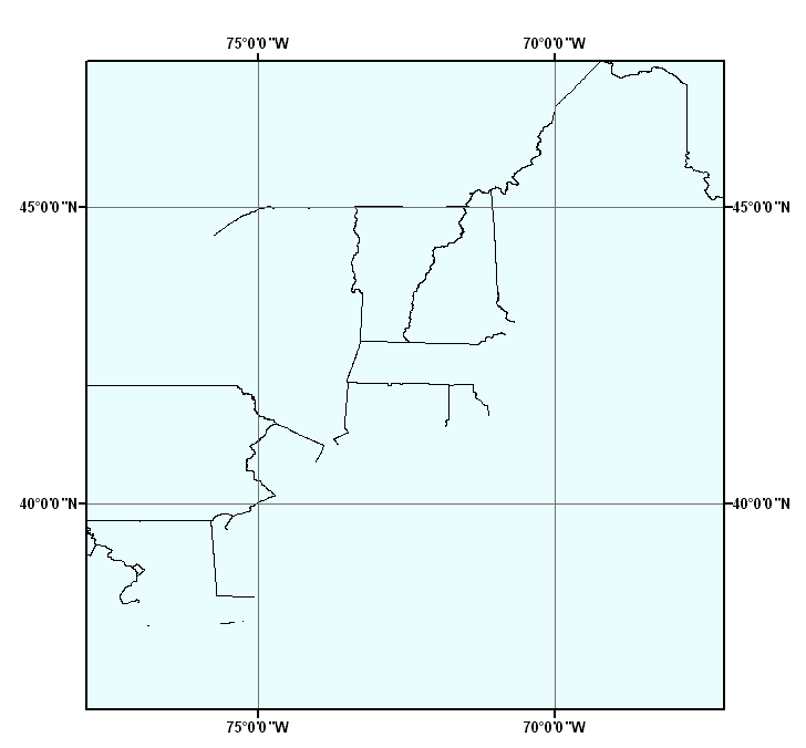
This data layer includes the internal boundaries for the United States and the political boundaries of the US, Canada and Mexico. The state boundaries are drawn to the US coastline and does not include any coastline or islands. This data layer may be used with the high resolution NOS80K coastline (allus80k.shp) which does not include any internal boundaries.
Paskevich, Valerie, 2003, STATE_BOUNDS: internal US state boundaries:.This is part of the following larger work.Online Links:
- <http://pubs.usgs.gov/of/2003/of03-001/data/basemaps/boundaries/state_bounds/state_bounds.zip>
- <http://pubs.usgs.gov/of/2003/of03-001/data/basemaps/boundaries/state_bounds/state_bounds.zip>
Poppe, L.J., Paskevich, V.F., Williams, S.J., Hastings, M.E., Kelley, J.T., Belknap, D.F., Ward, L.G., Fitzgerald, D.M., and Larsen, P.F., 2003, Surficial Sediment Data from the Gulf of Maine, Georges Bank, and vicinity: a GIS Compilation: Open-File Report 03-001, U. S. Geological Survey, Coastal and Marine Geology Program, Woods Hole Field Center, Woods Hole, MA.Online Links:
This is a Vector data set. It contains the following vector data types (SDTS terminology):
Horizontal positions are specified in geographic coordinates, that is, latitude and longitude. Latitudes are given to the nearest 0.0001. Longitudes are given to the nearest 0.0001. Latitude and longitude values are specified in Decimal degrees.
The horizontal datum used is North American Datum of 1983.
The ellipsoid used is Geodetic Reference System 80.
The semi-major axis of the ellipsoid used is 6378137.000000.
The flattening of the ellipsoid used is 1/298.257222.
Sequential unique whole numbers that are automatically generated.
Coordinates defining the features.
The true origin of this dataset is compiled from ESRI's 50 individual state 'trct' files. Please view the Source Information for more details
Valerie Paskevich
U. S. Geological Survey
Computer Specialist
384 Woods Hole Road
Woods Hole, MA 02543-1598
USA
(508) 548-8700 x2281 (voice)
(508) 457-2310 (FAX)
[email protected]
This dataset was created to be used with the NOS80K coastline (allus80k.shp) to provide state bounds without redrawing the coastline. In creating the data layer, some issues of the NOS80K coastline became apparent. One example, is the US/Mexico boundary. The NOS80K coastline closes and draws a straight line well below the Texas border. The same type of problem can be seen around the US/Canada boundary of the Great Lakes. The state_bounds.shp will draw the political boundaries while the allus80k.shp file will display the US beyond the political boundaries. If this is unacceptable to the user, they should consider masking the annexed US possession.
Paskevich, Valerie, Unpublished Material, USA: United States basemap data layer.
Person who carried out this activity:
Valerie PaskevichData sources used in this process:
U.S. Geological Survey
Computer Specialist
384 Woods Hole Road
Woods Hole, MA 02543-1598
USA
(508) 548-8700 x2281 (voice)
(508) 457-2310 (FAX)
[email protected]
Data sources produced in this process:
Person who carried out this activity:
Valerie PaskevichData sources used in this process:
U.S. Geological Survey
Information Specialist
384 Woods Hole Road
Woods Hole, MA 02543-1598
USA
(508) 548-8700 x2281 (voice)
(508) 457-2310 (FAX)
[email protected]
Data sources produced in this process:
This data set contains the internal boundaries for the continental US and the US/Canada and US/Mexico political boundaries.
No additional checks for topological consistency were performed on this data set.
Are there legal restrictions on access or use of the data?
- Access_Constraints: None
- Use_Constraints: None
U.S. Geological Survey
c/o Valerie Paskevich
Computer Specialist
384 Woods Hole Road
Woods Hole, MA 02543-1598
USA
(508) 548-8700 x2281 (voice)
(508) 457-2310 (FAX)
[email protected]
Downloadable Data; Regional Mapping of Surficial Sediments: Gulf of Maine and Georges Bank, Aggregates and Habitats Projects, state_bounds.shp
Although this derived data set and it's lineage dataset have been used by the USGS, no warranty, expressed or implied, is made by the USGS as to the accuracy of the data and/or related materials. The act of distribution shall not constitute any such warranty, and no responsibility is assumed by the USGS in the use of these data or related materials.
| Data format: | The three files that comprise the ArcView shapefile (state_bounds.dbf, state_bounds.shp, state_bounds.shx, state_bounds.prj, state_bounds.avl, state_bounds. state_bounds.sbx), 'prj' and 'avl' files, metadata and browse graphic. in format Shapefile (version ArcView 3.2) ESRI shapefile Size: 0.449 |
|---|---|
| Media you can order: |
CD-ROM
(Density 650
Mbytes)
Note: The user must have a computer system with a CD-ROM available. To browse the information contained on this CD-ROM, the user must have a current WWW browser available. The user must also have software installed on their computer to unzip the archived file.
|
The base map overlay is available as an ArcView shapefile format. The user must have ESRI's ArcView 3.0 or greater software to read and process the data file. In lieu of ArcView, the user may utilize another GIS application package capable of importing the data.
U.S. Geological Survey
c/o Valerie Paskevich
Computer Specialist
384 Woods Hole Road
Woods Hole, MA 02543-1598
USA
(508) 548-8700 x2281 (voice)
(508) 457-2310 (FAX)
[email protected]
OFR03-001 Home | Introduction | Nomenclature | Browse Maps | Data Catalog | Data Dictionary