|
 |
| U.S. Geological Survey
Open-File Report 03-001 |
|
|
LAKES: major lakes of the northeast United States
|
Metadata also available as: FAQ - TEXT
Metadata:
- Identification_Information:
-
- Citation:
-
- Citation_Information:
-
- Originator: Valerie Paskevich
- Publication_Date: 2003
- Title: LAKES: major lakes of the northeast United States
- Edition: 1.1
- Geospatial_Data_Presentation_Form: vector digital data
- Publication_Information:
-
- Publication_Place: Woods Hole Field Center, Woods Hole, MA
- Publisher: U.S. Geological Survey, Coastal and Marine Geology Program
- Online_Linkage:
-
<http://pubs.usgs.gov/of/2003/of03-001/data/basemaps/usa/water/lakes.zip>
- Online_Linkage:
-
<http://pubs.usgs.gov/of/2003/of03-001/data/basemaps/usa/water/lakes.zip>
- Larger_Work_Citation:
-
- Citation_Information:
-
- Originator: L.J. Poppe
- Originator: V.F. Paskevich
- Originator: S.J. Williams
- Originator: M.E. Hastings
- Originator: J.T. Kelley
- Originator: D.F. Belknap
- Originator: L.G. Ward
- Originator: D.M. FitzGerald
- Originator: P.F. Larsen
- Publication_Date: 2003
- Title:
-
Surficial Sediment Data from the Gulf of Maine, Georges Bank, and vicinity: a GIS Compilation
- Edition: 1.0
- Series_Information:
-
- Series_Name: Open-File Report
- Issue_Identification: 03-001
- Publication_Information:
-
- Publication_Place: Woods Hole Field Center, Woods Hole, MA
- Publisher: U.S. Geological Survey, Coastal and Marine Geology Program
- Other_Citation_Details:
-
Data is released via CD-ROM media. This digital publication may also be available via the web at pubs.usgs.gov
- Online_Linkage: <http://pubs.usgs.gov/of/2003/of03-001>
- Online_Linkage: <http://woodshole.er.usgs.gov/openfile/of03-001>
- Description:
-
- Abstract:
-
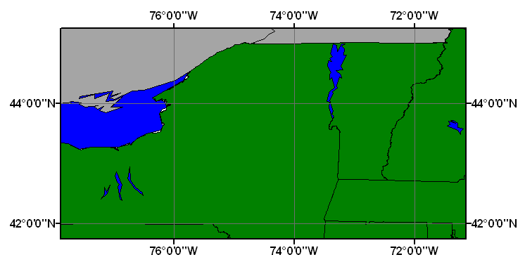
This ArcView shapefile represents the larger, major lakes within the United States. The shapefile dataset was provided by Environmental Research Institution, Inc. (ESRI) as data distribution with their software.
- Purpose:
-
This ArcView shapefile may be used as a general basemap data layer to illustrate the lakes of the United States.
- Supplemental_Information:
-
U.S. Lakes (LAKES) is an ESRI shapefile with polygon features. This is a subset of the original dataset. It has been clipped to the extent of the Gulf of Maine surficial sediment GIS project area.
- Time_Period_of_Content:
-
- Time_Period_Information:
-
- Single_Date/Time:
-
- Calendar_Date: 2003
- Currentness_Reference: publication date
- Status:
-
- Progress: Complete
- Maintenance_and_Update_Frequency: None planned
- Spatial_Domain:
-
- Bounding_Coordinates:
-
- West_Bounding_Coordinate: -77.877236
- East_Bounding_Coordinate: -71.198121
- North_Bounding_Coordinate: 45.000040
- South_Bounding_Coordinate: 42.392842
- Keywords:
-
- Theme:
-
- Theme_Keyword_Thesaurus: General
- Theme_Keyword: U.S. Geological Survey
- Theme_Keyword: USGS
- Theme_Keyword: ArcView polygon shapefile
- Theme_Keyword: basemap
- Theme_Keyword: major lakes of the northeastern United States
- Theme_Keyword: Open-File Report 03-001
- Theme_Keyword: OFR 03-001
- Place:
-
- Place_Keyword_Thesaurus: General
- Place_Keyword: United States
- Place_Keyword: northeast United States
- Place_Keyword: New England
- Place_Keyword: New Hampshire
- Place_Keyword: New York
- Place_Keyword: Lake Champlain
- Place_Keyword: Lake Winnipesaukee
- Place_Keyword: Lake Ontario
- Place_Keyword: Seneca Lake
- Access_Constraints: None
- Use_Constraints: None
- Point_of_Contact:
-
- Contact_Information:
-
- Contact_Person_Primary:
-
- Contact_Person: Valerie Paskevich
- Contact_Organization: U.S. Geological Survey
- Contact_Position: Information Specialist
- Contact_Address:
-
- Address_Type: mailing and physical address
- Address: 384 Woods Hole Road
- City: Woods Hole
- State_or_Province: MA
- Postal_Code: 02543-1598
- Country: USA
- Contact_Voice_Telephone: (508) 548-8700 x2281
- Contact_Facsimile_Telephone: (508) 457-2310
- Contact_Electronic_Mail_Address: [email protected]
- Browse_Graphic:
-
- Browse_Graphic_File_Name: lakes
- Browse_Graphic_File_Description:
-
Overview showing the extent of the clipped LAKES shapefile for the Gulf of Maine surficial sediment GIS project area.
- Browse_Graphic_File_Type: GIF
- Data_Set_Credit:
-
Please review the cross reference information for the original data set credit.
- Native_Data_Set_Environment:
-
Microsoft Windows 2000 Version 5.1 (Build 2600) ; ESRI ArcCatalog 8.2.0.700
- Cross_Reference:
-
- Citation_Information:
-
- Originator: Environmental Research Institution, Inc. (ESRI)
- Publication_Date: 1999
- Title: ESRI Data & Maps, Disk 1
- Edition: 1999
- Geospatial_Data_Presentation_Form: vector digital data
- Series_Information:
-
- Series_Name: ESRI Data and Maps CD
- Publication_Information:
-
- Publication_Place: Redlands, CA
- Publisher: Environmental Research Institution, Inc. (ESRI)
- Other_Citation_Details:
-
The data is organized on five CD-ROMS. CD#1 contains data for the world, Mexico, Canada, Europe and the United States. Detailed data for the entire United States is continued on CD #2. The very detailed data for the regions of the United States is split between the west (CD #3), the east (CD # 4), and the south (CD #5). Also, there is a sample image data on CD #5.
- Data_Quality_Information:
-
- Logical_Consistency_Report: none
- Completeness_Report:
-
This data set contains the US lakes shapefile clipped to the extent of the Gulf of Maine surficial sediment GIS project view area
- Lineage:
-
- Source_Information:
-
- Source_Citation:
-
- Citation_Information:
-
- Originator: Environmental Research Institution, Inc. (ESRI)
- Publication_Date: 19990801
- Publication_Time: Unknown
- Title: ESRI Data & maps
- Geospatial_Data_Presentation_Form: vector digital data
- Publication_Information:
-
- Publication_Place: Redlands, CA
- Publisher: Environmental Research Institution, Inc. (ESRI)
- Type_of_Source_Media: CD-ROM
- Source_Time_Period_of_Content:
-
- Time_Period_Information:
-
- Single_Date/Time:
-
- Calendar_Date: 1999
- Source_Currentness_Reference: publication date
- Source_Citation_Abbreviation: lakes.shp
- Source_Contribution:
-
The LAKES shapefile was taken in it's complete form from the ESRI data distribution disk.
- Process_Step:
-
- Process_Description:
-
The individual complete lakes shapefile was copied from the ESRI data distribution disk.
- Source_Used_Citation_Abbreviation: lakes.dbf
- Source_Used_Citation_Abbreviation: lakes.shp
- Source_Used_Citation_Abbreviation: lakes.shx
- Source_Produced_Citation_Abbreviation: lakes.dbf
- Source_Produced_Citation_Abbreviation: lakes.shp
- Source_Produced_Citation_Abbreviation: lakes.shx
- Process_Contact:
-
- Contact_Information:
-
- Contact_Person_Primary:
-
- Contact_Person: Valerie Paskevich
- Contact_Organization: U.S. Geological Survey
- Contact_Position: Information Specialist
- Contact_Address:
-
- Address_Type: mailing and physical address
- Address: 384 Woods Hole Road
- City: Woods Hole
- State_or_Province: MA
- Postal_Code: 02543-1598
- Country: USA
- Contact_Voice_Telephone: (508) 548-8700 x2281
- Contact_Facsimile_Telephone: (508) 457-2310
- Contact_Electronic_Mail_Address: [email protected]
- Process_Step:
-
- Process_Description:
-
The lakes shapefile was clipped using the ArcView extension Xtools to fit the extent of the Gulf of Maine surficial sediment GIS project view area. The Area attribute was then recomputed using the Xtools extension to reflect the new polygon values.
- Source_Used_Citation_Abbreviation: lakes.dbf
- Source_Used_Citation_Abbreviation: lakes.shp
- Source_Used_Citation_Abbreviation: lakes.shx
- Process_Date: 20021106
- Source_Produced_Citation_Abbreviation: lakes.dbf
- Source_Produced_Citation_Abbreviation: lakes.shp
- Source_Produced_Citation_Abbreviation: lakes.shx
- Process_Contact:
-
- Contact_Information:
-
- Contact_Person_Primary:
-
- Contact_Person: Valerie Paskevich
- Contact_Organization: U.S. Geological Survey
- Contact_Position: Information Specialist
- Contact_Address:
-
- Address_Type: mailing and physical address
- Address: 384 Woods Hole Road
- City: Woods Hole
- State_or_Province: MA
- Postal_Code: 02543-1598
- Country: USA
- Contact_Voice_Telephone: (508) 548-8700 x2281
- Contact_Facsimile_Telephone: (508) 457-2310
- Contact_Electronic_Mail_Address: [email protected]
- Spatial_Data_Organization_Information:
-
- Direct_Spatial_Reference_Method: Vector
- Point_and_Vector_Object_Information:
-
- SDTS_Terms_Description:
-
- SDTS_Point_and_Vector_Object_Type: G-polygon
- Point_and_Vector_Object_Count: 6
- Spatial_Reference_Information:
-
- Horizontal_Coordinate_System_Definition:
-
- Geographic:
-
- Latitude_Resolution: 0.000000
- Longitude_Resolution: 0.000000
- Geographic_Coordinate_Units: Decimal degrees
- Geodetic_Model:
-
- Horizontal_Datum_Name: North American Datum of 1983
- Ellipsoid_Name: Geodetic Reference System 80
- Semi-major_Axis: 6378137.000000
- Denominator_of_Flattening_Ratio: 298.257222
- Entity_and_Attribute_Information:
-
- Detailed_Description:
-
- Entity_Type:
-
- Entity_Type_Label: lakes.dbf
- Entity_Type_Definition: Shapefile Attribute Table
- Entity_Type_Definition_Source: ESRI
- Attribute:
-
- Attribute_Label: FID
- Attribute_Definition: Internal feature number.
- Attribute_Definition_Source: ESRI
- Attribute_Domain_Values:
-
- Range_Domain:
-
- Range_Domain_Minimum: 0.006
- Range_Domain_Maximum: 6.783
- Unrepresentable_Domain:
-
Sequential unique whole numbers that are automatically generated.
- Attribute:
-
- Attribute_Label: Shape
- Attribute_Definition: Feature geometry.
- Attribute_Definition_Source: ESRI
- Attribute_Domain_Values:
-
- Unrepresentable_Domain: Coordinates defining the features.
- Attribute:
-
- Attribute_Label: AREA
- Attribute_Definition: Area of Polygon in native units
- Attribute_Definition_Source: Software Computed
- Attribute_Domain_Values:
-
- Range_Domain:
-
- Range_Domain_Minimum: 54.765
- Range_Domain_Maximum: 7746.332
- Attribute_Units_of_Measure: decimal degrees
- Attribute:
-
- Attribute_Label: NAME
- Attribute_Definition: Lake Name
- Attribute_Definition_Source: User Defined
- Attribute_Domain_Values:
-
- Unrepresentable_Domain: Character String
- Attribute_Domain_Values:
-
- Enumerated_Domain:
-
- Enumerated_Domain_Value: Lake Champlain
- Enumerated_Domain_Value_Definition: Lake Champlain
- Enumerated_Domain:
-
- Enumerated_Domain_Value: Lake Ontario
- Enumerated_Domain_Value_Definition: Lake Ontario
- Enumerated_Domain:
-
- Enumerated_Domain_Value: Lake Winnipesaukee
- Enumerated_Domain_Value_Definition: Lake Winnipesaukee
- Enumerated_Domain:
-
- Enumerated_Domain_Value: Seneca Lake
- Enumerated_Domain_Value_Definition: Seneca Lake
- Distribution_Information:
-
- Distributor:
-
- Contact_Information:
-
- Contact_Organization_Primary:
-
- Contact_Organization: U. S. Geological Survey
- Contact_Person: Valerie Paskevich
- Contact_Position: Computer Specialist
- Contact_Address:
-
- Address_Type: mailing and physical address
- Address: 384 Woods Hole Road
- City: Woods Hole
- State_or_Province: MA
- Postal_Code: 02543-1598
- Country: USA
- Contact_Voice_Telephone: (508) 548-8700 x2281
- Contact_Facsimile_Telephone: (508) 457-2310
- Contact_Electronic_Mail_Address: [email protected]
- Resource_Description:
-
Downloadable Data: Regional Mapping of Surficial Sediments: Gulf of Maine and Georges Bank, Aggregates and Habitats Projects, lakes.shp
- Distribution_Liability:
-
Although this derived data set and it's lineage dataset have been used by the USGS, no warranty, expressed or implied, is made by the USGS as to the accuracy of the data and/or related materials. The act of distribution shall not constitute any such warranty, and no responsibility is assumed by the USGS in the use of these data or related materials.
- Standard_Order_Process:
-
- Digital_Form:
-
- Digital_Transfer_Information:
-
- Format_Name: ArcView Shapefile
- Format_Version_Number: 3.2
- Format_Specification: ESRI polygon shapefile
- Format_Information_Content:
-
The three ArcView shapefiles (lakes.dbf, lakes.shp, lakes.shx) comprising the ArcView polygon, 'prj' and 'avl' files, metadata text file and browse graphic.
- File_Decompression_Technique: zip
- Transfer_Size: 6.113
- Digital_Transfer_Option:
-
- Offline_Option:
-
- Offline_Media: CD-ROM
- Recording_Capacity:
-
- Recording_Density: 650
- Recording_Density_Units: Mbytes
- Compatibility_Information:
-
The user must have a computer system with a CD-ROM available. To browse the information contained on this CD-ROM, the user must have a current WWW browser available. The user must also have software installed on their computer to unzip the archived file.
- Fees: none
- Technical_Prerequisites:
-
The United States base map overlay is available as an ArcView shapefile format. The user must have ESRI's ArcView 3.0 or greater software to read and process the data file. In lieu of Arcview, the user may utilize another GIS application package capable of importing the data.
- Metadata_Reference_Information:
-
- Metadata_Date: 20030311
- Metadata_Contact:
-
- Contact_Information:
-
- Contact_Organization_Primary:
-
- Contact_Organization: U. S. Geological Survey
- Contact_Person: Valerie Paskevich
- Contact_Position: Information Specialist
- Contact_Address:
-
- Address_Type: mailing and physical address
- Address: 384 Woods Hole Rd.
- City: Woods Hole
- State_or_Province: MA
- Postal_Code: 02543-1598
- Country: USA
- Contact_Voice_Telephone: (508) 548-8700 x2281
- Contact_Facsimile_Telephone: (508) 457-2310
- Contact_Electronic_Mail_Address: [email protected]
- Metadata_Standard_Name: FGDC Content Standards for Digital Geospatial Metadata
- Metadata_Standard_Version: FGDC-STD-001-1998
- Metadata_Time_Convention: local time
- Metadata_Access_Constraints: None
- Metadata_Use_Constraints: None
Generated by mp version 2.7.3 on Tue Mar 11 09:00:24 2003
OFR03-001 Home | Introduction
| Nomenclature | Browse
Maps | Data Catalog | Data
Dictionary
[an error occurred while processing this directive]