|
 |
| U.S. Geological Survey
Open-File Report 03-001 |
|
|
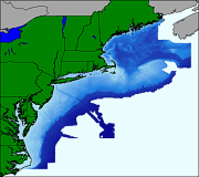
SEAGRD.TIF: image representation of the NGDC Coastal Relief Model bathymetry for the project area
|
Metadata also available as: FAQ - TEXT
Metadata:
- Identification_Information:
-
- Citation:
-
- Citation_Information:
-
- Originator: U.S. Geological Survey
- Originator: Valerie Paskevich
- Publication_Date: 2003
- Title:
-
SEAGRD.TIF: image representation of the NGDC Coastal Relief Model bathymetry for the project area
- Edition: 1.0
- Geospatial_Data_Presentation_Form: remote-sensing image
- Publication_Information:
-
- Publication_Place: Woods Hole Field Center, Woods Hole, MA
- Publisher: U.S. Geological Survey, Coastal and Marine Geology Program
- Online_Linkage: <http://pubs.usgs.gov/of/2003/of03-001/data/images/seagrd.zip>
- Online_Linkage:
-
<http://pubs.usgs.gov/of/2003/of03-001/data/images/seagrd.zip>
- Larger_Work_Citation:
-
- Citation_Information:
-
- Originator: L.J. Poppe
- Originator: V.F. Paskevich
- Originator: S.J. Williams
- Originator: M.E. Hastings
- Originator: J.T. Kelley
- Originator: D.F. Belknap
- Originator: L.G. Ward
- Originator: D.M. FitzGerald
- Originator: P.F. Larsen
- Publication_Date: 2003
- Title:
-
Surficial Sediment Data from the Gulf of Maine, Georges Bank, and vicinity: a GIS Compilation
- Edition: 1.0
- Series_Information:
-
- Series_Name: Open-File Report
- Issue_Identification: 03-001
- Publication_Information:
-
- Publication_Place: Woods Hole Field Center, Woods Hole, MA
- Publisher: U.S. Geological Survey, Coastal and Marine Geology Program
- Other_Citation_Details:
-
Data is released via CD-ROM media. This digital publication may also be available via the web at pubs.usgs.gov
- Online_Linkage: <http://pubs.usgs.gov/of/2003/of03-001>
- Online_Linkage: <http://woodshole.er.usgs.gov/openfile/of03-001>
- Description:
-
- Abstract:
-
The National Geophysical Data Center assembled a gridded database referred to as the Coastal Relief Model (CRM). NGDC created the comprehensive data set by merging the US Geological Survey 3-arc-second DEMs with a compilation of hydrographic soundings covering the US East Coast. The Coastal Relief Model extends from the coastal state boundaries to as far offshore as the data will support a continuous view of the seafloor. One component of the NGDC database are 3-arc-second elevation grids. This dataset formed the basis for the creation of the Coastal Relief Model bathymetry image for the project GIS.
- Purpose:
-
This image provides a color encoded view of the Coastal Relief Model for the project area and is used as a basemap data layer for overlaying the surficial sediment data.
- Time_Period_of_Content:
-
- Time_Period_Information:
-
- Single_Date/Time:
-
- Calendar_Date: 2003
- Currentness_Reference: publication date
- Status:
-
- Progress: Complete
- Maintenance_and_Update_Frequency: None planned
- Spatial_Domain:
-
- Bounding_Coordinates:
-
- West_Bounding_Coordinate: -77.75
- East_Bounding_Coordinate: -65
- North_Bounding_Coordinate: 45.25
- South_Bounding_Coordinate: 35
- Keywords:
-
- Theme:
-
- Theme_Keyword_Thesaurus: General
- Theme_Keyword: U.S. Geological Survey
- Theme_Keyword: USGS
- Theme_Keyword: Coastal and Marine Geology Program
- Theme_Keyword: CMGP
- Theme_Keyword: National Geophysical Data Center
- Theme_Keyword: Coastal Relief Model
- Theme_Keyword: Geographic Information System
- Theme_Keyword: GIS
- Theme_Keyword: GEOTIFF image
- Theme_Keyword: CRM
- Theme_Keyword: bathymetry
- Theme_Keyword: National Assessment of Marine Sand and Gravel Resources
- Theme_Keyword: Open-File Report 03-001
- Theme_Keyword: OFR 03-001
- Place:
-
- Place_Keyword_Thesaurus: General
- Place_Keyword: United States East Coast
- Place_Keyword: U.S. East Coast
- Place_Keyword: U.S. northeast
- Place_Keyword: New England
- Place_Keyword: Mid-Atlantic
- Place_Keyword: Gulf of Maine
- Place_Keyword: New York Bight
- Place_Keyword: Maine
- Place_Keyword: New Hampshire
- Place_Keyword: Massachusetts
- Place_Keyword: Rhode Island
- Place_Keyword: Connecticut
- Place_Keyword: New York
- Place_Keyword: New Jersey
- Place_Keyword: Delaware
- Place_Keyword: Maryland
- Place_Keyword: Virginia
- Place_Keyword: North Carolina
- Place_Keyword: continental shelf
- Place_Keyword: continental margin
- Place_Keyword: Georges Bank
- Access_Constraints: None
- Use_Constraints: This dataset is not to be used for navigation purposes.
- Point_of_Contact:
-
- Contact_Information:
-
- Contact_Person_Primary:
-
- Contact_Person: Valerie Paskevich
- Contact_Organization: U.S. Geological Survey
- Contact_Position: Information Technology Specialist
- Contact_Address:
-
- Address_Type: mailing and physical address
- Address: 384 Woods Hole Road
- City: Woods Hole
- State_or_Province: MA
- Postal_Code: 02543-1598
- Country: USA
- Contact_Voice_Telephone: (508) 548-8700 x2281
- Contact_Facsimile_Telephone: (508) 457-2310
- Contact_Electronic_Mail_Address: vpaskevich@usgs.gov
- Browse_Graphic:
-
- Browse_Graphic_File_Name: seagrd.gif
- Browse_Graphic_File_Description:
-
Image map showing extent of the CRM bathymetry along the US eastcoast shapefile for the project area.
- Browse_Graphic_File_Type: GIF
- Native_Data_Set_Environment:
-
Microsoft Windows 2000 Version 5.1 (Build 2600) ; ESRI ArcCatalog 8.2.0.700
- Data_Quality_Information:
-
- Lineage:
-
- Source_Information:
-
- Source_Citation:
-
- Citation_Information:
-
- Originator: National Geophysical Data Center
- Title: Coastal Relief Model, East Coast, Vol 1
- Edition: 1.0
- Geospatial_Data_Presentation_Form: vector digital data
- Series_Information:
-
- Series_Name: NGDC Coastal Relief Model
- Issue_Identification: volume 1
- Publication_Information:
-
- Publication_Place: Boulder, CO
- Publisher:
-
National Oceanic and Atmospheric Administration (NOAA), National Geophysical Data Center (NGDC)
- Online_Linkage: <http://www.ngdc.noaa.gov/mgg/coastal/coastal.html>
- Online_Linkage:
-
<http://ols.nndc.noaa.gov/plolstore/plsql/olstore.prodspecific?prodnum=G01338-CDR-A0001>
- Type_of_Source_Media: CD-ROM
- Source_Citation_Abbreviation: NGDC Coastal Relief Model, East Coast, Vol 1
- Source_Contribution:
-
The Volume 1 Coastal Relief Model was combined with Volume 2 to create a raster grid of the US northeast Atlantic.
- Source_Information:
-
- Source_Citation:
-
- Citation_Information:
-
- Originator: National Geophysical Data Center
- Title: Coastal Relief Model, East Coast, Vol 2
- Edition: 1.0
- Geospatial_Data_Presentation_Form: vector digital data
- Series_Information:
-
- Series_Name: NGDC Coastal Relief Model
- Issue_Identification: volume 2
- Publication_Information:
-
- Publication_Place: Boulder, CO
- Publisher:
-
National Oceanic and Atmospheric Administration (NOAA), National Geophysical Data Center (NGDC)
- Online_Linkage: <http://www.ngdc.noaa.gov/mgg/coastal/coastal.html>
- Online_Linkage:
-
<http://ols.nndc.noaa.gov/plolstore/plsql/olstore.prodspecific?prodnum=G01339-CDR-A0001>
- Type_of_Source_Media: CD-ROM
- Source_Citation_Abbreviation: NGDC Coastal Relief Model, East Coast, Vol 2
- Source_Contribution:
-
A subset of the Volume 2 Coastal Relief Model was combined with Volume 1 to create a raster grid of the US northeast Atlantic north of 35 deg.
- Process_Step:
-
- Process_Description:
-
The desired data was extracted from the Coastal Relief Model volumes 1 & 2 in the ESRI ASCII grid format.
- Source_Used_Citation_Abbreviation: Coastal Relief Model, East Coast vol 1
- Source_Used_Citation_Abbreviation: Coastal Relief Model, East Coast vol 2
- Source_Produced_Citation_Abbreviation: crmvol1.asc
- Source_Produced_Citation_Abbreviation: crmvol2.asc
- Process_Contact:
-
- Contact_Information:
-
- Contact_Person_Primary:
-
- Contact_Person: Valerie Paskevich
- Contact_Organization: U.S. Geological Survey
- Contact_Position: Information Technology Specialist
- Contact_Address:
-
- Address_Type: mailing and physical address
- Address: 384 Woods Hole Road
- City: Woods Hole
- State_or_Province: MA
- Postal_Code: 02543-1598
- Country: USA
- Contact_Voice_Telephone: (508) 548-8700 x2281
- Contact_Facsimile_Telephone: (508) 457-2310
- Contact_Electronic_Mail_Address: vpaskevich@usgs.gov
- Process_Step:
-
- Process_Description:
-
The ASCII dataset was then converted to an ESRI grid file and combined to a single ESRI grid file.
- Source_Used_Citation_Abbreviation: crmvol1.asc
- Source_Used_Citation_Abbreviation: crmvol2.asc
- Process_Date: Unknown
- Source_Produced_Citation_Abbreviation: seagrd
- Process_Contact:
-
- Contact_Information:
-
- Contact_Person_Primary:
-
- Contact_Person: Valerie Paskevich
- Contact_Organization: U.S. Geological Survey
- Contact_Position: Information Technology Specialist
- Contact_Address:
-
- Address_Type: mailing and physical address
- Address: 384 Woods Hole Road
- City: Woods Hole
- State_or_Province: MA
- Postal_Code: 02543-1598
- Country: USA
- Contact_Voice_Telephone: (508) 548-8700 x2281
- Contact_Facsimile_Telephone: (508) 457-2310
- Contact_Electronic_Mail_Address: vpaskevich@usgs.gov
- Process_Step:
-
- Process_Description:
-
The GRID data was exported as a TIF image for inclusion in the Gulf of Maine GIS
- Process_Date: 200302012
- Process_Contact:
-
- Contact_Information:
-
- Contact_Person_Primary:
-
- Contact_Person: Valerie Paskevich
- Contact_Organization: U.S. Geological Survey
- Contact_Position: Information Technology Specialist
- Contact_Address:
-
- Address_Type: mailing and physical address
- Address: 384 Woods Hole Road
- City: Woods Hole
- State_or_Province: MA
- Postal_Code: 02543-1598
- Country: USA
- Contact_Voice_Telephone: (508) 548-8700 x2281
- Contact_Facsimile_Telephone: (508) 457-2310
- Contact_Electronic_Mail_Address: vpaskevich@usgs.gov
- Spatial_Data_Organization_Information:
-
- Direct_Spatial_Reference_Method: Raster
- Raster_Object_Information:
-
- Raster_Object_Type: Pixel
- Row_Count: 5402
- Column_Count: 6720
- Vertical_Count: 1
- Spatial_Reference_Information:
-
- Horizontal_Coordinate_System_Definition:
-
- Planar:
-
- Planar_Coordinate_Information:
-
- Planar_Coordinate_Encoding_Method: row and column
- Coordinate_Representation:
-
- Abscissa_Resolution: 0.001897
- Ordinate_Resolution: 0.001898
- Geodetic_Model:
-
- Ellipsoid_Name: WGS1984
- Distribution_Information:
-
- Distributor:
-
- Contact_Information:
-
- Contact_Person_Primary:
-
- Contact_Person: Valerie Paskevich
- Contact_Organization: U.S. Geological Survey
- Contact_Position: GIS Coordinator
- Contact_Address:
-
- Address_Type: mailing and physical address
- Address: 384 Woods Hole Road
- City: Woods Hole
- State_or_Province: MA
- Postal_Code: 02543-1598
- Country: USA
- Contact_Voice_Telephone: (508) 548-8700 x2281
- Contact_Facsimile_Telephone: (508) 457-2310
- Contact_Electronic_Mail_Address: vpaskevich@usgs.gov
- Resource_Description:
-
Downloadable Data; National Assessment of Marine Sand and Gravel Resources: seagrd.tif
- Distribution_Liability:
-
Although this data set has been used by the U.S. Geological Survey, no warranty, expressed or implied, is made by the USGS as to the accuracy of the data and/or related materials. The act of distribution shall not constitute any such warranty, and no responsibility is assumed by the USGS in the use of these data or related materials. The act of distribution shall not constitute any such warranty, and no responsibility is assumed by the USGS in the use of these data or related materials.
- Standard_Order_Process:
-
- Digital_Form:
-
- Digital_Transfer_Information:
-
- Format_Name: TIFF
- Format_Specification: GEOTIFF
- Format_Information_Content:
-
Tiff image, world file and an ASCII version of the metadata file
- File_Decompression_Technique: zip
- Transfer_Size: 103.901
- Digital_Transfer_Option:
-
- Offline_Option:
-
- Offline_Media: CD-ROM
- Recording_Capacity:
-
- Recording_Density: 650
- Recording_Density_Units: Mbytes
- Compatibility_Information:
-
The user must have a computer system with a CD-ROM available. To browse the information contained on this CD-ROM, the user must have a current WWW browser available. The user must also have software installed on their computer to unzip the archived file.
- Technical_Prerequisites:
-
The data is available in ArcView shapefile format. The user must have ArcView 3.0 or greater software to read and process the data file. In lieu of ArcView, the user may utilize another GIS application package capable of importing data.
- Metadata_Reference_Information:
-
- Metadata_Date: 20030219
- Metadata_Contact:
-
- Contact_Information:
-
- Contact_Person_Primary:
-
- Contact_Person: Valerie Paskevich
- Contact_Organization: U.S. Geological Survey
- Contact_Position: Information Technology Specialist
- Contact_Address:
-
- Address_Type: mailing and physical address
- Address: 384 Woods Hole Road
- City: Woods Hole
- State_or_Province: MA
- Postal_Code: 02543-1598
- Country: USA
- Contact_Voice_Telephone: (508) 548-8700 x2281
- Contact_Facsimile_Telephone: (508) 457-2310
- Contact_Electronic_Mail_Address: vpaskevich@usgs.gov
- Metadata_Standard_Name: FGDC Content Standards for Digital Geospatial Metadata
- Metadata_Standard_Version: FGDC-STD-001-1998
- Metadata_Time_Convention: local time
- Metadata_Access_Constraints: None
- Metadata_Use_Constraints: None
Generated by mp version 2.7.3 on Wed Feb 19 10:00:19 2003
OFR03-001 Home | Introduction
| Nomenclature | Browse
Maps | Data Catalog | Data
Dictionary
[an error occurred while processing this directive]