|

|
| U.S. Geological Survey
Open-File Report 03-001 |
|
|
BARNHARDT: Maine Inner Continental Shelf Sediment Data
|
Metadata also available as: FAQ
- TEXT
Metadata:
- Identification_Information:
-
- Citation:
-
- Citation_Information:
-
- Originator: Lawrence J. Poppe
- Originator: Mary E. Hastings
- Publication_Date: 2003
- Title: BARNHARDT: Maine Inner Continental Shelf Sediment
Data
- Edition: 1.0
- Geospatial_Data_Presentation_Form: vector digital data
- Publication_Information:
-
- Publication_Place: Woods Hole Field Center, Woods
Hole, MA
- Publisher: U. S. Geological Survey, Coastal and
Marine Geology Program
- Online_Linkage:
- <http://pubs.usgs.gov/of/2003/of03-001/data/seddata/barnhardt/barnhardt.zip>
- Online_Linkage:
- <http://pubs.usgs.gov/of/2003/of03-001/data/seddata/barnhardt/barnhardt.zip>
- Larger_Work_Citation:
-
- Citation_Information:
-
- Originator: L.J. Poppe
- Originator: V.F. Paskevich
- Originator: S.J. Williams
- Originator: M.E. Hastings
- Originator: J.T. Kelley
- Originator: D.F. Belknap
- Originator: L.G. Ward
- Originator: D.M. FitzGerald
- Originator: P.F. Larsen
- Publication_Date: 2003
- Title:
- Surficial Sediment Data from the Gulf of Maine, Georges
Bank, and vicinity: a GIS Compilation
- Edition: 1.0
- Series_Information:
-
- Series_Name: Open-File Report
- Issue_Identification: 03-001
- Publication_Information:
-
- Publication_Place: Woods Hole Field Center,
Woods Hole, MA
- Publisher: U. S. Geological Survey, Coastal
and Marine Geology Program
- Other_Citation_Details:
- Data is released via CD-ROM media. This digital publication
may also be available via the web at pubs.usgs.gov
- Online_Linkage: <http://pubs.usgs.gov/of/2003/of03-001>
- Online_Linkage: <http://woodshole.er.usgs.gov/openfile/of03-001>
- Description:
-
- Abstract:
- Surficial geologic maps play and important role in understanding
the present sea floor and the processes that shape it. Between 1984 and 1991,
over 1,700 bottom sample stations were occupied in the northwestern Gulf
of Maine. Although the data were originally collected for a variety of research
projects, contracts, and graduate student theses, they were eventually compiled
as part of a Maine Geological Survey and University of Maine program to map
the inner continental shelf of this region.
- Purpose:
- The purpose of this data layer is to make available a subset
of a data set produced by the Maine Geological Survey and the University
of Maine. This subset contains information for those samples with raw grain
size data, and which are located on the inner continental shelf from the
northwestern Gulf of Maine.
- Time_Period_of_Content:
-
- Time_Period_Information:
-
- Single_Date/Time:
-
- Calendar_Date: 1998
- Currentness_Reference: publication date
- Status:
-
- Progress: Complete
- Maintenance_and_Update_Frequency: None planned
- Spatial_Domain:
-
- Bounding_Coordinates:
-
- West_Bounding_Coordinate: -70.812833
- East_Bounding_Coordinate: -67.129700
- North_Bounding_Coordinate: 44.578314
- South_Bounding_Coordinate: 42.833833
- Keywords:
-
- Theme:
-
- Theme_Keyword_Thesaurus: General
- Theme_Keyword: U.S. Geological Survey
- Theme_Keyword: USGS
- Theme_Keyword: University of Maine
- Theme_Keyword: Maine Geological Survey
- Theme_Keyword: Woods Hole Field Center
- Theme_Keyword: sediment
- Theme_Keyword: texture
- Theme_Keyword: lithology
- Theme_Keyword: gravel
- Theme_Keyword: sand
- Theme_Keyword: silt
- Theme_Keyword: clay
- Theme_Keyword: mud
- Theme_Keyword: Open-File Report 03-001
- Theme_Keyword: Coastal and Marine Geology Program
- Theme_Keyword: CMGP
- Theme_Keyword: sediment classification
- Theme_Keyword: surficial classification
- Theme_Keyword: ArcView shapefile
- Theme_Keyword: points
- Theme_Keyword: Geographic Information System
- Theme_Keyword: GIS
- Place:
-
- Place_Keyword_Thesaurus: General
- Place_Keyword: U.S. East Coast
- Place_Keyword: Gulf of Maine
- Place_Keyword: Atlantic
- Place_Keyword: Inner Continental Shelf
- Place_Keyword: New England
- Access_Constraints: None
- Use_Constraints: None
- Point_of_Contact:
-
- Contact_Information:
-
- Contact_Person_Primary:
-
- Contact_Person: Lawrence J. Poppe
- Contact_Organization: U.S. Geological Survey
- Contact_Position: Geologist
- Contact_Address:
-
- Address_Type: mailing and physical address
- Address: 384 Woods Hole Road
- City: Woods Hole
- State_or_Province: MA
- Postal_Code: 02543-1598
- Country: USA
- Contact_Voice_Telephone: 508-548-8700 x2314
- Contact_Facsimile_Telephone: 508-457-2310
- Contact_Electronic_Mail_Address: [email protected]
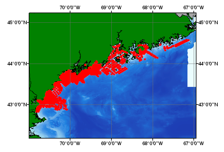
- Browse_Graphic:
-
- Browse_Graphic_File_Name: barnhardt
- Browse_Graphic_File_Description:
- Image map showing extent and distribution of data layer coverage.
- Browse_Graphic_File_Type: GIF
- Data_Set_Credit:
- Please review the cross reference information for the original
data set credit to Kelley and others (1998), and Larry Poppe for creating
this ArcView shapefile.
- Native_Data_Set_Environment:
- Microsoft Windows 2000 Version 5.1 (Build 2600) ; ESRI ArcCatalog
8.2.0.700
- Cross_Reference:
-
- Citation_Information:
-
- Originator: J.T. Kelley
- Originator: W.A. Barnhardt
- Originator: D.F. Belknap
- Originator: S.M. Dickson
- Originator: A.R. Kelley
- Publication_Date: 1998
- Title:
- The Seafloor Revealed: The Geology of the Northwestern Gulf
of Maine Inner Continental Shelf
- Edition: 1.0
- Series_Information:
-
- Series_Name: Maine Geological Survey Open-File
- Issue_Identification: 96-6, 55 p.
- Publication_Information:
-
- Publication_Place: Augusta, ME
- Publisher: Maine Geological Survey, Department
of Conservation
- Cross_Reference:
-
- Citation_Information:
-
- Originator: W.A. Barnhardt
- Originator: J.T. Kelley
- Originator: S.M. Dickson
- Originator: D.F. Belknap
- Originator: A.R. Kelley
- Publication_Date: 1996
- Title: Surficial Geology of the Maine Inner Continental
Shelf
- Edition: 1.0
- Series_Information:
-
- Series_Name: Maine Geological Survey Map Series
- Issue_Identification: scale 1:100,000
- Publication_Information:
-
- Publication_Place: Augusta, ME
- Publisher: Maine Geological Survey
- Data_Quality_Information:
-
- Attribute_Accuracy:
-
- Attribute_Accuracy_Report:
- All attributes were checked by the compilers in a consistent
manner.
- Logical_Consistency_Report:
- No additional checks for topological consistency were performed
on this data.
- Completeness_Report:
- Sample locations, grain-size data, textural classifications, and
sample identifiers are provided for 1,739
- Positional_Accuracy:
-
- Horizontal_Positional_Accuracy:
-
- Horizontal_Positional_Accuracy_Report:
- Navigation was variously performed with Loran C (+/- 100 m
accuracy) and dfferential GPS (+/- 10 m accuracy). No location-by-location
differentiation is made between these navigational systems.
- Lineage:
-
- Source_Information:
-
- Source_Citation:
-
- Citation_Information:
-
- Originator: J.T. Kelley
- Originator: W.A. Barnhardt
- Originator: D.F. Belknap
- Originator: S.M. Dickson
- Originator: A.R. Kelley
- Publication_Date: 1998
- Title:
- The Seafloor Revealed: The Geology of the Northwestern
Gulf of Maine Inner Continental Shelf
- Edition: 1.0
- Series_Information:
-
- Series_Name: Maine Geological Survey Open-File
- Issue_Identification: 96-6, 55 p.
- Publication_Information:
-
- Publication_Place: Augusta, ME
- Publisher: Maine Geological Survey, Department
of Conservation
- Type_of_Source_Media: CD-ROM
- Source_Time_Period_of_Content:
-
- Time_Period_Information:
-
- Single_Date/Time:
-
- Calendar_Date: 1998
- Source_Currentness_Reference: publication date
- Source_Information:
-
- Source_Citation:
-
- Citation_Information:
-
- Originator: W.A. Barnhadt
- Originator: J.T. Kelley
- Originator: S.M. Dickson
- Originator: D.F. Belknap
- Originator: A.R. Kelley
- Publication_Date: 1996
- Title: Surficial Geology of the Maine Inner Continental
Shelf
- Edition: 1.0
- Series_Information:
-
- Series_Name: Maine Geological Survey Map Series
- Issue_Identification: scale 1:100,000
- Publication_Information:
-
- Publication_Place: Augusta, ME
- Publisher: Maine Geological Survey
- Process_Step:
-
- Process_Description:
- Textural and lithologic data from the northwestern Gulf of
Maine were clipped from the whole Maine Geological Survey and University
of Maine dataset from the Surficial Geology of the Maine Inner Continental
Shelf map series in Excel and exported to an ASCII file. Stations and sediment
data were imported from the ASCII text file to an ArcView table. The table
was later converted to an event theme and saved as the final shapefile.
- Source_Used_Citation_Abbreviation: barnhardt.txt
- Process_Date: 20021029
- Source_Produced_Citation_Abbreviation: barnhardt.shp
- Source_Produced_Citation_Abbreviation: barnhardt.dbf
- Source_Produced_Citation_Abbreviation: barnhardt.shx
- Process_Contact:
-
- Contact_Information:
-
- Contact_Person_Primary:
-
- Contact_Person: Lawrence J. Poppe
- Contact_Organization: U.S. Geological Survey
- Contact_Position: Geologist
- Contact_Address:
-
- Address_Type: mailing and physical address
- Address: 384 Woods Hole Road
- City: Woods Hole
- State_or_Province: MA
- Postal_Code: 02543-1598
- Country: USA
- Contact_Voice_Telephone: 508-548-8700 x2314
- Contact_Facsimile_Telephone: 508-457-2310
- Contact_Electronic_Mail_Address: [email protected]
- Spatial_Data_Organization_Information:
-
- Direct_Spatial_Reference_Method: Vector
- Point_and_Vector_Object_Information:
-
- SDTS_Terms_Description:
-
- SDTS_Point_and_Vector_Object_Type: Entity point
- Point_and_Vector_Object_Count: 1739
- Spatial_Reference_Information:
-
- Horizontal_Coordinate_System_Definition:
-
- Geographic:
-
- Latitude_Resolution: 0.00000001
- Longitude_Resolution: 0.00000001
- Geographic_Coordinate_Units: Decimal degrees
- Geodetic_Model:
-
- Horizontal_Datum_Name: North American Datum of 1927
- Ellipsoid_Name: Clarke 1866
- Semi-major_Axis: 6378206.400000
- Denominator_of_Flattening_Ratio: 294.978698
- Entity_and_Attribute_Information:
-
- Detailed_Description:
-
- Entity_Type:
-
- Entity_Type_Label: barnhardt.dbf
- Entity_Type_Definition: Shapefile Attribute Table
- Entity_Type_Definition_Source: ESRI
- Attribute:
-
- Attribute_Label: FID
- Attribute_Definition: Internal feature number.
- Attribute_Definition_Source: ESRI
- Attribute_Domain_Values:
-
- Unrepresentable_Domain:
- Sequential unique whole numbers that are automatically generated.
- Attribute:
-
- Attribute_Label: Shape
- Attribute_Definition: Feature geometry.
- Attribute_Definition_Source: ESRI
- Attribute_Domain_Values:
-
- Unrepresentable_Domain: Coordinates defining the
features.
- Attribute:
-
- Attribute_Label: SITE
- Attribute_Definition: Unique number assigned to each
sample location
- Attribute_Definition_Source: Scientist
- Attribute_Domain_Values:
-
- Range_Domain:
-
- Range_Domain_Minimum: 1
- Range_Domain_Maximum: 1902
- Attribute_Units_of_Measure: stations
- Attribute_Measurement_Resolution: 1
- Attribute:
-
- Attribute_Label: SAMPLE
- Attribute_Definition: Name used to identify samples
- Attribute_Definition_Source: Scentist
- Attribute_Domain_Values:
-
- Unrepresentable_Domain: Names of characters and
munerics identifying samples
- Attribute:
-
- Attribute_Label: LATITUDE
- Attribute_Definition: Latitude coordinate of sample
location
- Attribute_Definition_Source: Scientist
- Attribute_Domain_Values:
-
- Range_Domain:
-
- Range_Domain_Minimum: 42.833833
- Range_Domain_Maximum: 44.578314
- Attribute_Units_of_Measure: decimal degrees
- Attribute_Measurement_Resolution: 0.000001
- Attribute:
-
- Attribute_Label: LONGITUDE
- Attribute_Definition: Longitude coordinate of sample
location
- Attribute_Definition_Source: Scientist
- Attribute_Domain_Values:
-
- Range_Domain:
-
- Range_Domain_Minimum: -70.812833
- Range_Domain_Maximum: -67.129300
- Attribute_Units_of_Measure: decimal degrees
- Attribute_Measurement_Resolution: 0.000001
- Attribute:
-
- Attribute_Label: DEPTH_M
- Attribute_Definition: Water depth in meters
- Attribute_Definition_Source: Scientist
- Attribute_Domain_Values:
-
- Range_Domain:
-
- Range_Domain_Minimum: 0
- Range_Domain_Maximum: 211
- Attribute_Units_of_Measure: meters
- Attribute_Measurement_Resolution: 1
- Attribute:
-
- Attribute_Label: C_CODE
- Attribute_Definition: Classification code
- Attribute_Definition_Source: Scientist
- Attribute_Domain_Values:
-
- Unrepresentable_Domain: Abbreviations of lithologic
descriptions
- Attribute:
-
- Attribute_Label: LITHOLOGY
- Attribute_Definition: Lithologic/textural descriptions
of the seafloor
- Attribute_Definition_Source: Scientist
- Attribute_Domain_Values:
-
- Unrepresentable_Domain: Lithologic descriptions
- Attribute:
-
- Attribute_Label: GRAVEL
- Attribute_Definition: Percentage of gravel
- Attribute_Definition_Source: Scientist
- Attribute_Domain_Values:
-
- Range_Domain:
-
- Range_Domain_Minimum: 0
- Range_Domain_Maximum: 100
- Attribute_Units_of_Measure: percent
- Attribute_Measurement_Resolution: 1
- Attribute:
-
- Attribute_Label: SAND
- Attribute_Definition: Percentage of sand in sample
- Attribute_Definition_Source: Scientist
- Attribute_Domain_Values:
-
- Range_Domain:
-
- Range_Domain_Minimum: 0
- Range_Domain_Maximum: 100
- Attribute_Units_of_Measure: percent
- Attribute_Measurement_Resolution: 1
- Attribute:
-
- Attribute_Label: SILT
- Attribute_Definition: Percentage of silt in sample
- Attribute_Definition_Source: Scientist
- Attribute_Domain_Values:
-
- Range_Domain:
-
- Range_Domain_Minimum: 0
- Range_Domain_Maximum: 74
- Attribute_Units_of_Measure: percent
- Attribute_Measurement_Resolution: 1
- Attribute:
-
- Attribute_Label: CLAY
- Attribute_Definition: Percentage of clay in sample
- Attribute_Definition_Source: Scientist
- Attribute_Domain_Values:
-
- Range_Domain:
-
- Range_Domain_Minimum: 0
- Range_Domain_Maximum: 85
- Attribute_Units_of_Measure: percent
- Attribute_Measurement_Resolution: 1
- Attribute:
-
- Attribute_Label: MUD
- Attribute_Definition: Percentage of mud (silt plus
clay) in sample
- Attribute_Definition_Source: Scientist
- Attribute_Domain_Values:
-
- Range_Domain:
-
- Range_Domain_Minimum: 0
- Range_Domain_Maximum: 100
- Attribute_Units_of_Measure: percent
- Attribute_Measurement_Resolution: 1
- Attribute:
-
- Attribute_Label: MEAN_PHI
- Attribute_Definition: Mean of the grain size distribution
in phi
- Attribute_Definition_Source: Scientist
- Attribute_Domain_Values:
-
- Range_Domain:
-
- Range_Domain_Minimum: -4.9
- Range_Domain_Maximum: 11.6
- Attribute_Units_of_Measure: phi
- Attribute_Measurement_Resolution: 0.1
- Attribute:
-
- Attribute_Label: STDDEV
- Attribute_Definition: Standard deviation of the grain
size distribution in phi units
- Attribute_Definition_Source: Scientist
- Attribute_Domain_Values:
-
- Range_Domain:
-
- Range_Domain_Minimum: 0
- Range_Domain_Maximum: 7.6
- Attribute_Units_of_Measure: phi
- Attribute_Measurement_Resolution: 0.1
- Attribute:
-
- Attribute_Label: BAY
- Attribute_Definition: Bay or region where the sample
was collected.
- Attribute_Definition_Source: Scientist
- Attribute_Domain_Values:
-
- Unrepresentable_Domain: Names of bays and regions
along the inner continental shelf
- Distribution_Information:
-
- Distributor:
-
- Contact_Information:
-
- Contact_Person_Primary:
-
- Contact_Person: Lawrence J. Poppe
- Contact_Organization: U.S. Geological Survey
- Contact_Position: Geologist
- Contact_Address:
-
- Address_Type: mailing and physical address
- Address: 384 Woods Hole Road
- City: Woods Hole
- State_or_Province: MA
- Postal_Code: 02543-1598
- Country: USA
- Contact_Voice_Telephone: 508-548-8700 x2314
- Contact_Facsimile_Telephone: 508-457-2310
- Contact_Electronic_Mail_Address: [email protected]
- Resource_Description:
- Regional Mapping of Surficial Sediments: Gulf of Maine and Georges
Bank, Aggregates and Habitats Projects, barnhardt.shp
- Distribution_Liability:
- Although this data set has been used by the U.S. Geological Survey,
no warranty, expressed or implied, is made by the USGS as to the accuracy
of the data and/or related materials. The act of distribution shall not
constitute any such warranty, and no responsibility is assumed by the USGS
in the use of these data or related materials.
- Standard_Order_Process:
-
- Digital_Form:
-
- Digital_Transfer_Information:
-
- Format_Name: ArcView shapefile
- Format_Version_Number: 3.2
- Format_Specification: ESRI point shapefile
- Format_Information_Content:
- Five files (barnhardt.shp, barnhardt.dbf, barnhardt.shx,
barnhardt.sbx, barnhardt.sbn) comprising the ArcView point shapefile components,
'prj' and 'avl' files, metadata text file and browse graphic.
- File_Decompression_Technique: zip
- Transfer_Size: 0.447
- Digital_Transfer_Option:
-
- Offline_Option:
-
- Offline_Media: CD-ROM
- Recording_Capacity:
-
- Recording_Density: 650
- Recording_Density_Units: Mbytes
- Compatibility_Information:
- The user must have a computer system with a CD-ROM available.
To browse the information contained on this CD-ROM, the user must have a
current WWW browser available. The user must also have software installed
on their computer to unzip the archived file.
- Fees: None
- Technical_Prerequisites:
- The data is available in ArcView shapefile format. The user must
have ArcView 3.0 or greater software to read and process the data file.
In lieu of ArcView, the user may utilize another GIS application package
capable of importing data.
- Available_Time_Period:
-
- Time_Period_Information:
-
- Single_Date/Time:
-
- Calendar_Date: 2002
- Metadata_Reference_Information:
-
- Metadata_Date: 20030216
- Metadata_Contact:
-
- Contact_Information:
-
- Contact_Person_Primary:
-
- Contact_Person: Lawrence J. Poppe
- Contact_Organization: U.S. Geological Survey
- Contact_Position: Geologist
- Contact_Address:
-
- Address_Type: mailing and physical address
- Address: 384 Woods Hole Road
- City: Woods Hole
- State_or_Province: MA
- Postal_Code: 02543-1598
- Country: USA
- Contact_Voice_Telephone: 508-548-8700 x2314
- Contact_Facsimile_Telephone: 508-457-2310
- Contact_Electronic_Mail_Address: [email protected]
- Metadata_Standard_Name: FGDC Content Standards for Digital
Geospatial Metadata
- Metadata_Standard_Version: FGDC-STD-001-1998
- Metadata_Time_Convention: local time
- Metadata_Access_Constraints: None
- Metadata_Use_Constraints: None
Generated by mp
version 2.7.3 on Sun Feb 16 12:13:07 2003
OFR03-001 Home | Introduction | Nomenclature | Browse Maps | Data Catalog | Data Dictionary
[an error occurred while processing this directive]