|
 |
| U.S. Geological Survey
Open-File Report 03-001 |
|
|
GARRISON66: Sediments on the Shelf off Southern New England
|
Metadata also available as: FAQ - TEXT
Metadata:
- Identification_Information:
-
- Citation:
-
- Citation_Information:
-
- Originator: Lawrence J. Poppe
- Publication_Date: 2003
- Title: GARRISON66: Sediments on the Shelf off Southern New England
- Edition: 1.0
- Geospatial_Data_Presentation_Form: vector digital data
- Series_Information:
- Publication_Information:
-
- Publication_Place: Woods Hole Field Center, Woods Hole, MA
- Publisher: U. S. Geological Survey, Coastal and Marine Geology Program
- Online_Linkage:
-
<http://pubs.usgs.gov/of/2003/of03-001/data/seddata/garrison66/garrison66.zip>
- Online_Linkage:
-
<http://pubs.usgs.gov/of/2003/of03-001/data/seddata/garrison66/garrison66.zip>
- Larger_Work_Citation:
-
- Citation_Information:
-
- Originator: L.J. Poppe
- Originator: V.F. Paskevich
- Originator: S.J. Williams
- Originator: M.E. Hastings
- Originator: J.T. Kelley
- Originator: D.F. Belknap
- Originator: L.G. Ward
- Originator: D.M. FitzGerald
- Originator: P.F. Larsen
- Publication_Date: 2003
- Title:
-
Surficial Sediment Data from the Gulf of Maine, Georges Bank, and vicinity: a GIS Compilation
- Edition: 1.0
- Geospatial_Data_Presentation_Form: vector digital data
- Series_Information:
-
- Series_Name: Open-File Report
- Issue_Identification: 03-001
- Publication_Information:
-
- Publication_Place: Woods Hole Field Center, Woods Hole, MA
- Publisher: U. S. Geological Survey, Coastal and Marine Geology Program
- Other_Citation_Details:
-
Data is released via CD-ROM media. This digital publication may also be available via the web at pubs.usgs.gov
- Online_Linkage: <http://pubs.usgs.gov/of/2003/of03-001>
- Online_Linkage: <http://pubs.usgs.gov/of/2003/of03-001>
- Description:
-
- Abstract:
-
The sediments and geomorphology of a portion of the northeastern continental shelf between Hudson Canyon and Georges Bank have been investigated. Wave-cut terraces at 13, 45, 65, and 80 fathoms indicate four former low sea levels, while concentrations of beach ridges around 35 fathoms reveal a fifth. The pre-Holocene drainage pattern, still exposed over part of the area, shows that Block Channel was the main stream system which drained most of southern New England. The surface sediments on the western part of the study area are Late Pleistocene fluvial deposits. Overlying these coarse deposits in the central part of the outer shelf is a sandy silt facies that is also relict. The youngest facies and the only area of present deposition, is in the
northeastern part where sand eroded from Nantucket Shoals is being deposited on the shelf.
- Purpose:
-
The purpose of this data layer is to release a digital version of the sediment data published in Garrison and McMaster (1966).
- Time_Period_of_Content:
-
- Time_Period_Information:
-
- Single_Date/Time:
-
- Calendar_Date: 1966
- Currentness_Reference: publication date
- Status:
-
- Progress: Complete
- Maintenance_and_Update_Frequency: None planned
- Spatial_Domain:
-
- Bounding_Coordinates:
-
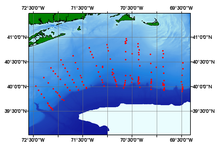
- West_Bounding_Coordinate: -72.447000
- East_Bounding_Coordinate: -69.467000
- North_Bounding_Coordinate: 40.970000
- South_Bounding_Coordinate: 39.533000
- Keywords:
-
- Theme:
-
- Theme_Keyword_Thesaurus: General
- Theme_Keyword: U.S. Geological Survey
- Theme_Keyword: USGS
- Theme_Keyword: Coastal and Marine Geology Program
- Theme_Keyword: CMGP
- Theme_Keyword: Woods Hole Field Center
- Theme_Keyword: ArcView
- Theme_Keyword: shapefile
- Theme_Keyword: sediments
- Theme_Keyword: texture
- Theme_Keyword: grabs
- Theme_Keyword: cores
- Theme_Keyword: lithology
- Theme_Keyword: Open-File Report 03-001
- Theme_Keyword: Open-File Report 03-001
- Theme_Keyword: surficial classification
- Theme_Keyword: sediment classification
- Theme_Keyword: points
- Theme_Keyword: GIS
- Theme_Keyword: Geographic Information System
- Place:
-
- Place_Keyword_Thesaurus: General
- Place_Keyword: U.S. East Coast
- Place_Keyword: Block Island
- Place_Keyword: Rhode Island Sound
- Place_Keyword: continental shelf
- Place_Keyword: New England
- Place_Keyword: Atlantic
- Place_Keyword: Georges Bank
- Place_Keyword: Nantucket Shoals
- Access_Constraints: None
- Use_Constraints: None
- Point_of_Contact:
-
- Contact_Information:
-
- Contact_Person_Primary:
-
- Contact_Person: Lawrence J. Poppe
- Contact_Organization: U.S. Geological Survey
- Contact_Position: Geologist
- Contact_Address:
-
- Address_Type: mailing and physical address
- Address: 384 Woods Hole Road
- City: Woods Hole
- State_or_Province: MA
- Postal_Code: 02543-1598
- Country: USA
- Contact_Voice_Telephone: 508-548-8700 x2314
- Contact_Facsimile_Telephone: 508-457-2310
- Contact_Electronic_Mail_Address: lpoppe@usgs.gov
- Browse_Graphic:
-
- Browse_Graphic_File_Name: garisson66
- Browse_Graphic_File_Description:
-
Image map showing extent and distribution of data layer coverage.
- Browse_Graphic_File_Type: GIF
- Data_Set_Credit:
-
Please review the cross section information for the original data set credit to L.E. Garrison and R.L. McMaster (1966). Larry Poppe for entering the data from the source report and creating the ArcView shapefile.
- Native_Data_Set_Environment:
-
Microsoft Windows 2000 Version 5.1 (Build 2600) ; ESRI ArcCatalog 8.2.0.700
- Cross_Reference:
-
- Citation_Information:
-
- Originator: L.E. Garrison
- Originator: R.L. McMaster
- Publication_Date: 1966
- Title:
-
Sediments and Geomorphology of the Continental Shelf off Southern New England
- Edition: 1.0
- Geospatial_Data_Presentation_Form: map
- Series_Information:
-
- Series_Name: Marine Geology
- Issue_Identification: v. 4, p. 273-289.
- Publication_Information:
-
- Publication_Place: Amsterdam
- Publisher: Elsevier
- Data_Quality_Information:
-
- Logical_Consistency_Report:
-
No additional checks for topological consistency were performed on this data.
- Completeness_Report:
-
Sample locations and textural classifications are provided for 145 grab and coring stations.
- Positional_Accuracy:
-
- Horizontal_Positional_Accuracy:
-
- Horizontal_Positional_Accuracy_Report:
-
Navagational methods are not discussed in the original report. Horizontal accuracy is unknown.
- Vertical_Positional_Accuracy:
-
- Vertical_Positional_Accuracy_Report: Tides are less han 2 m
- Quantitative_Vertical_Positional_Accuracy_Assessment:
-
- Vertical_Positional_Accuracy_Value: 2
- Lineage:
-
- Source_Information:
-
- Source_Citation:
-
- Citation_Information:
-
- Originator: L.E. Garrison
- Originator: R.L. McMaster
- Publication_Date: 1966
- Title:
-
Sediments and Geomorphology of the Continental Shelf off Southern New England
- Edition: 1.0
- Series_Information:
-
- Series_Name: Marine Geology
- Issue_Identification: v. 4, p. 273-289.
- Publication_Information:
-
- Publication_Place: Amsterdam
- Publisher: Elsevier
- Type_of_Source_Media: paper
- Source_Time_Period_of_Content:
-
- Time_Period_Information:
-
- Single_Date/Time:
-
- Calendar_Date: 1966
- Source_Currentness_Reference: publication date
- Process_Step:
-
- Process_Description:
-
The navigation was digitized from maps in the original paper. The remaining source information was manually entered into digital form and together were imported from an ASCII text file into an ArcView table. The table was later converted to an event theme in ArcView and saved as the final shapefile.
- Source_Used_Citation_Abbreviation: garrison66.txt
- Process_Date: 20020910
- Source_Produced_Citation_Abbreviation: garrison66.shp
- Source_Produced_Citation_Abbreviation: garrison66.dbf
- Source_Produced_Citation_Abbreviation: garrison66.shx
- Process_Contact:
-
- Contact_Information:
-
- Contact_Person_Primary:
-
- Contact_Person: Lawrence J. Poppe
- Contact_Organization: U.S. Geological Survey
- Contact_Position: Geologist
- Contact_Address:
-
- Address_Type: mailing and physical address
- Address: 384 Woods Hole Road
- City: Woods Hole
- State_or_Province: MA
- Postal_Code: 02543-1598
- Country: USA
- Contact_Voice_Telephone: 508-548-8700 x2314
- Contact_Facsimile_Telephone: 508-457-2310
- Contact_Electronic_Mail_Address: lpoppe@usgs.gov
- Spatial_Data_Organization_Information:
-
- Direct_Spatial_Reference_Method: Vector
- Point_and_Vector_Object_Information:
-
- SDTS_Terms_Description:
-
- SDTS_Point_and_Vector_Object_Type: Entity point
- Point_and_Vector_Object_Count: 145
- Spatial_Reference_Information:
-
- Horizontal_Coordinate_System_Definition:
-
- Geographic:
-
- Latitude_Resolution: 0.000000
- Longitude_Resolution: 0.000000
- Geographic_Coordinate_Units: Decimal degrees
- Geodetic_Model:
-
- Horizontal_Datum_Name: North American Datum of 1927
- Ellipsoid_Name: Clarke 1866
- Semi-major_Axis: 6378206.400000
- Denominator_of_Flattening_Ratio: 294.978698
- Entity_and_Attribute_Information:
-
- Detailed_Description:
-
- Entity_Type:
-
- Entity_Type_Label: garrison66.dbf
- Entity_Type_Definition: Shapefile Attribute Table
- Entity_Type_Definition_Source: ESRI
- Attribute:
-
- Attribute_Label: FID
- Attribute_Definition: Internal feature number.
- Attribute_Definition_Source: ESRI
- Attribute_Domain_Values:
-
- Unrepresentable_Domain:
-
Sequential unique whole numbers that are automatically generated.
- Attribute:
-
- Attribute_Label: Shape
- Attribute_Definition: Feature geometry.
- Attribute_Definition_Source: ESRI
- Attribute_Domain_Values:
-
- Unrepresentable_Domain: Coordinates defining the features.
- Attribute:
-
- Attribute_Label: CONSECNO
- Attribute_Definition: Sample id assigned to distinguish between stations.
- Attribute_Definition_Source: Complier
- Attribute_Domain_Values:
-
- Range_Domain:
-
- Range_Domain_Minimum: 1
- Range_Domain_Maximum: 145
- Attribute_Units_of_Measure: integer count
- Attribute_Measurement_Resolution: 1
- Attribute:
-
- Attribute_Label: PROJECTID
- Attribute_Definition: Project id assigned to the data set for future identification.
- Attribute_Definition_Source: Compiler
- Attribute_Domain_Values:
-
- Enumerated_Domain:
-
- Enumerated_Domain_Value: GARRISON66
- Enumerated_Domain_Value_Definition: Scientist and year of publication
- Enumerated_Domain_Value_Definition_Source: Compiler
- Attribute:
-
- Attribute_Label: CRUISEID
- Attribute_Definition: Abbreviation of ship name and cruise number.
- Attribute_Definition_Source: Scientist
- Attribute_Domain_Values:
-
- Enumerated_Domain:
-
- Enumerated_Domain_Value: TR-009
- Enumerated_Domain_Value_Definition: Ship and cruise
- Enumerated_Domain_Value_Definition_Source: Scientist
- Attribute:
-
- Attribute_Label: STATION
- Attribute_Definition: Site at which a sample was taken
- Attribute_Definition_Source: Scientist
- Attribute_Domain_Values:
-
- Unrepresentable_Domain: Assigned characters and numerics
- Attribute:
-
- Attribute_Label: DEVICE
- Attribute_Definition: Specific grab or core used to collect a sample
- Attribute_Definition_Source: Scientist
- Attribute_Domain_Values:
-
- Enumerated_Domain:
-
- Enumerated_Domain_Value: SMITH-MACINTYRE GRAB
- Enumerated_Domain_Value_Definition: Smith-MacIntyre Grab Sampler
- Enumerated_Domain:
-
- Enumerated_Domain_Value: VANVEEN GRAB
- Enumerated_Domain_Value_Definition: VanVeen Grab Sampler
- Enumerated_Domain:
-
- Enumerated_Domain_Value: PISTON CORE
- Enumerated_Domain_Value_Definition: Piston Core sampling device
- Enumerated_Domain:
-
- Enumerated_Domain_Value: GRAVITY CORE
- Enumerated_Domain_Value_Definition: Gravity Core sampling device
- Attribute:
-
- Attribute_Label: DATE
- Attribute_Definition: Year, month and day when sample was collected
- Attribute_Definition_Source: Scientist
- Attribute_Domain_Values:
-
- Unrepresentable_Domain: Character String; YYYMMDD
- Attribute:
-
- Attribute_Label: LATITUDE
- Attribute_Definition: Latitude coordinates of sample location.
- Attribute_Definition_Source: Scientist
- Attribute_Domain_Values:
-
- Range_Domain:
-
- Range_Domain_Minimum: 39.5300
- Range_Domain_Maximum: 40.9700
- Attribute_Units_of_Measure: decimal degrees
- Attribute_Measurement_Resolution: .0001
- Attribute:
-
- Attribute_Label: LONGITUDE
- Attribute_Definition: Longitude of sample station.
- Attribute_Definition_Source: Scientist
- Attribute_Domain_Values:
-
- Range_Domain:
-
- Range_Domain_Minimum: -72.447
- Range_Domain_Maximum: -69.467
- Attribute_Units_of_Measure: decimal degrees
- Attribute_Measurement_Resolution: .001
- Attribute:
-
- Attribute_Label: DEPTH
- Attribute_Definition: Water depth in meters at the corresponding station.
- Attribute_Definition_Source: Scientist
- Attribute_Domain_Values:
-
- Range_Domain:
-
- Range_Domain_Minimum: 40
- Range_Domain_Maximum: 355
- Attribute_Units_of_Measure: meters
- Attribute_Measurement_Resolution: 1
- Attribute_Value_Accuracy_Information:
-
- Attribute_Value_Accuracy: 1
- Attribute:
-
- Attribute_Label: DOMINANT_L
- Attribute_Definition: Primarly lithology
- Attribute_Definition_Source: Scientist
- Attribute_Domain_Values:
-
- Enumerated_Domain:
-
- Enumerated_Domain_Value: SAND
- Enumerated_Domain_Value_Definition: Sand content
- Enumerated_Domain_Value_Definition_Source: Visual examination of sample by scientist
- Enumerated_Domain:
-
- Enumerated_Domain_Value: MUD
- Enumerated_Domain_Value_Definition: Mud content
- Enumerated_Domain_Value_Definition_Source: Visual examination of sample by scientist
- Enumerated_Domain:
-
- Enumerated_Domain_Value: CLAY
- Enumerated_Domain_Value_Definition: Clay content
- Enumerated_Domain_Value_Definition_Source: Visual examination of sample by scientist
- Enumerated_Domain:
-
- Enumerated_Domain_Value: SILT
- Enumerated_Domain_Value_Definition: Silt content
- Enumerated_Domain_Value_Definition_Source: Visual examination of sample by scientist
- Attribute:
-
- Attribute_Label: SECOND_LIT
- Attribute_Definition: Secondary lithology
- Attribute_Definition_Source: Scientist
- Attribute_Domain_Values:
-
- Enumerated_Domain:
-
- Enumerated_Domain_Value: CLAY
- Enumerated_Domain_Value_Definition: Clay content
- Enumerated_Domain_Value_Definition_Source: Visual examination of sample by scientist
- Enumerated_Domain:
-
- Enumerated_Domain_Value: COARSER THAN SAND
- Enumerated_Domain_Value_Definition: coarser than sand
- Enumerated_Domain_Value_Definition_Source: Visual examination of sample by scientist
- Enumerated_Domain:
-
- Enumerated_Domain_Value: SAND
- Enumerated_Domain_Value_Definition: Sand content
- Enumerated_Domain_Value_Definition_Source: Visual examination of sample by scientist
- Enumerated_Domain:
-
- Enumerated_Domain_Value: SILT
- Enumerated_Domain_Value_Definition: Silt content
- Enumerated_Domain_Value_Definition_Source: Visual examination of sample by scientist
- Attribute_Domain_Values:
-
- Unrepresentable_Domain: Field is blank; no secondary lithology assigned
- Attribute:
-
- Attribute_Label: GRAVEL
- Attribute_Definition: Percentage of gravel in a sample
- Attribute_Definition_Source: Scientist
- Attribute_Domain_Values:
-
- Range_Domain:
-
- Range_Domain_Minimum: 0
- Range_Domain_Maximum: 39
- Attribute_Units_of_Measure: percent
- Attribute_Measurement_Resolution: 0.01
- Attribute:
-
- Attribute_Label: SAND
- Attribute_Definition: Percentage of sand in a sample.
- Attribute_Definition_Source: Scientist
- Attribute_Domain_Values:
-
- Range_Domain:
-
- Range_Domain_Minimum: 0
- Range_Domain_Maximum: 99.8
- Attribute_Units_of_Measure: percent
- Attribute_Measurement_Resolution: 0.01
- Attribute:
-
- Attribute_Label: SILT
- Attribute_Definition: Percentage of silt in a sample
- Attribute_Definition_Source: Scientist
- Attribute_Domain_Values:
-
- Range_Domain:
-
- Range_Domain_Minimum: 0
- Range_Domain_Maximum: 83.59
- Attribute_Units_of_Measure: percent
- Attribute_Measurement_Resolution: 0.01
- Attribute:
-
- Attribute_Label: CLAY
- Attribute_Definition: Percentage of clay in a sample
- Attribute_Definition_Source: Scientist
- Attribute_Domain_Values:
-
- Range_Domain:
-
- Range_Domain_Minimum: 0
- Range_Domain_Maximum: 40.52
- Attribute_Units_of_Measure: percent
- Attribute_Measurement_Resolution: 0.01
- Attribute:
-
- Attribute_Label: SHEPARD_CL
- Attribute_Definition:
-
Classification of the sediment size distribution based on a scheme devied by Shepard (1954)
- Attribute_Definition_Source: Compiler
- Attribute_Domain_Values:
-
- Unrepresentable_Domain:
-
Character string; Verbal equivalents of the Shephard classification scheme
- Attribute_Domain_Values:
-
- Enumerated_Domain:
-
- Enumerated_Domain_Value: SAND
- Enumerated_Domain_Value_Definition: Sand content
- Enumerated_Domain_Value_Definition_Source: Data Compiler
- Enumerated_Domain:
-
- Enumerated_Domain_Value: SAND SILT CLAY
- Enumerated_Domain_Value_Definition: sand, silt and clay content
- Enumerated_Domain_Value_Definition_Source: Data Compiler
- Enumerated_Domain:
-
- Enumerated_Domain_Value: SANDY SILT
- Enumerated_Domain_Value_Definition: sandy silt content
- Enumerated_Domain_Value_Definition_Source: Data Compiler
- Enumerated_Domain:
-
- Enumerated_Domain_Value: SILT
- Enumerated_Domain_Value_Definition: silt content
- Enumerated_Domain_Value_Definition_Source: Data Compiler
- Enumerated_Domain:
-
- Enumerated_Domain_Value: SILTY SAND
- Enumerated_Domain_Value_Definition: silty sand content
- Enumerated_Domain_Value_Definition_Source: Data Compiler
- Attribute_Domain_Values:
-
- Unrepresentable_Domain: Field is blank; no classification is assigned
- Overview_Description:
-
- Entity_and_Attribute_Overview:
-
Sediment grain-size data, textural classifications, lithologic descriptions, navigation, and identifiers for the samples collected aboard the Trident by Garrison and McMaster (1966)
- Distribution_Information:
-
- Distributor:
-
- Contact_Information:
-
- Contact_Person_Primary:
-
- Contact_Person: Lawrence J. Poppe
- Contact_Organization: U.S. Geological Survey
- Contact_Position: Geologist
- Contact_Address:
-
- Address_Type: mailing and physical address
- Address: 384 Woods Hole Road
- City: Woods Hole
- State_or_Province: MA
- Postal_Code: 02543-1598
- Country: USA
- Contact_Voice_Telephone: 508-548-8700 x2314
- Contact_Facsimile_Telephone: 508-457-2310
- Contact_Electronic_Mail_Address: lpoppe@usgs.gov
- Resource_Description:
-
Regional Mapping of Surficial Sediments: Gulf of Maine and Georges Bank, Aggregates and Habitats Projects, garrison66.shp
- Distribution_Liability:
-
Although this data set has been used by the U.S. Geological Survey, no warranty, expressed or implied, is made by the USGS as to the accuracy of the data and/or related materials. The act of distribution shall not constitute any such warranty, and no responsibility is assumed by the USGS in the use of these data or related materials.
- Standard_Order_Process:
-
- Digital_Form:
-
- Digital_Transfer_Information:
-
- Format_Name: ArcView shapefile
- Format_Version_Number: 3.2
- Format_Specification: ESRI point shapefile
- Format_Information_Content:
-
Five files (garrison66.shp, garrison66.dbf, garrison66.shx, garrison66.sbx, garrison66.sbn) comprising the ArcView point shapefile components, 'prj' and 'avl' files, metadata text file and browse graphic.
- File_Decompression_Technique: zip
- Transfer_Size: 0.162
- Digital_Transfer_Option:
-
- Offline_Option:
-
- Offline_Media: CD-ROM
- Recording_Capacity:
-
- Recording_Density: 650
- Recording_Density_Units: Mbytes
- Compatibility_Information:
-
The user must have a computer system with a CD-ROM available. To browse the information contained on this CD-ROM, the user must have a current WWW browser available. The user must also have software installed on their computer to unzip the archived file.
- Fees: None
- Technical_Prerequisites:
-
The data is availabe in ArcView shaefile format. The user must have ESRI's ArcView 3.0 or greater software to read and process the data file. In lieu of ArcVew, the user may utilize another GIS application package capable of importing data.
- Available_Time_Period:
-
- Time_Period_Information:
-
- Single_Date/Time:
-
- Calendar_Date: 2002
- Metadata_Reference_Information:
-
- Metadata_Date: 20030321
- Metadata_Contact:
-
- Contact_Information:
-
- Contact_Person_Primary:
-
- Contact_Person: Lawrence J. Poppe
- Contact_Organization: U.S. Geological Survey
- Contact_Position: Geologist
- Contact_Address:
-
- Address_Type: mailing and physical address
- Address: 384 Woods Hole Road
- City: Woods Hole
- State_or_Province: MA
- Postal_Code: 02543-1598
- Country: USA
- Contact_Voice_Telephone: 508-548-8700 x2314
- Contact_Facsimile_Telephone: 508-457-2310
- Contact_Electronic_Mail_Address: lpoppe@usgs.gov
- Metadata_Standard_Name: FGDC Content Standards for Digital Geospatial Metadata
- Metadata_Standard_Version: FGDC-STD-001-1998
- Metadata_Time_Convention: local time
- Metadata_Access_Constraints: None
- Metadata_Use_Constraints: None
Generated by mp version 2.7.3 on Fri Mar 21 10:22:15 2003
OFR03-001 Home | Introduction
| Nomenclature | Browse
Maps | Data Catalog | Data
Dictionary
[an error occurred while processing this directive]