|
 |
| U.S. Geological Survey
Open-File Report 03-001 |
|
|
GOMCSDB: Gulf of Maine Contaminated Sediments Database
|
Metadata also available as: FAQ - TEXT
Metadata:
- Identification_Information:
-
- Citation:
-
- Citation_Information:
-
- Originator: Lawrence J. Poppe
- Publication_Date: 2003
- Title: GOMCSDB: Gulf of Maine Contaminated Sediments Database
- Edition: 1.0
- Geospatial_Data_Presentation_Form: vector digital data
- Publication_Information:
-
- Publication_Place: Woods Hole Field Center, Woods Hole, MA
- Publisher: U. S. Geological Survey, Coastal and Marine Geology Program
- Online_Linkage:
-
<http://pubs.usgs.gov/of/2003/of03-001/data/seddata/gomcsdb/gomcsdb.zip>
- Online_Linkage:
-
<http://pubs.usgs.gov/of/2003/of03-001/data/seddata/gomcsdb/gomcsdb.zip>
- Larger_Work_Citation:
-
- Citation_Information:
-
- Originator: L.J. Poppe
- Originator: V.F. Paskevich
- Originator: S.J. Williams
- Originator: M.E. Hastings
- Originator: J.T. Kelley
- Originator: D.F. Belknap
- Originator: L.G. Ward
- Originator: D.M. FitzGerald
- Originator: P.F. Larsen
- Publication_Date: 2003
- Title:
-
Surficial Sediment Data from the Gulf of Maine, Georges Bank, and vicinity: a GIS Compilation
- Edition: 1.0
- Series_Information:
-
- Series_Name: Open-File Report
- Issue_Identification: 03-001
- Publication_Information:
-
- Publication_Place: Woods Hole Field Center, Woods Hole, MA
- Publisher: U. S. Geological Survey, Coastal and Marine Geology Program
- Other_Citation_Details:
-
Data are released via CD-ROM media. This digital publication may also be available via the web at pubs.usgs.gov
- Online_Linkage: <http://pubs.usgs.gov/of/2003/of03-001>
- Online_Linkage: <http://pubs.usgs.gov/of/2003/of03-001>
- Description:
-
- Abstract:
-
The Contaminated Sediments Database for the Gulf of Maine provides a compilation and synthesis of existing data to help establish the environmental status of our coastal sediments and the transport paths and fate of contaminants in this region. This information, in turn, forms one of the essential bases for developing successful remediation and resource management policies.
The Contaminated Sediments Database for the Gulf of Maine provides a compilation and synthesis of existing data to help establish the environmental status of our coastal sediments and the transport paths and fate of contaminants in this region. This information, in turn, forms one of the essential bases for developing successful remediation and resource management policies
This product is the result of a collaborative effort of principal investigators from the U.S. Geological Survey Coastal and Marine Geology Program, Woods Hole Oceanographic Institution, the University of New Hampshire, Bigelow Laboratory for Ocean Sciences, the University of Massachusetts, and active participation from the U.S. Army Corps of Engineers, the U.S. Environmental Protection Agency, the Massachusetts Water Resources Authority, the National Oceanic and Atmospheric Administration, and other federal and state agencies. Funding was provided by participating institutions and the Gulf of Maine Regional Marine Research Program.
- Purpose:
-
The purpose of this data layer is to release a subset of the Gulf of Maine Contaminated Sediments Database that can be used to interpret surficial sediment distribution off the northeastern U.S.
- Time_Period_of_Content:
-
- Time_Period_Information:
-
- Single_Date/Time:
-
- Calendar_Date: 2002
- Currentness_Reference: publication date
- Status:
-
- Progress: Complete
- Maintenance_and_Update_Frequency: None planned
- Spatial_Domain:
-
- Bounding_Coordinates:
-
- West_Bounding_Coordinate: -71.100000
- East_Bounding_Coordinate: -67.335000
- North_Bounding_Coordinate: 44.678000
- South_Bounding_Coordinate: 40.400000
- Keywords:
-
- Theme:
-
- Theme_Keyword_Thesaurus: General
- Theme_Keyword: U.S. Geological Survey
- Theme_Keyword: USGS
- Theme_Keyword: Woods Hole Field Center
- Theme_Keyword: sediment
- Theme_Keyword: texture
- Theme_Keyword: gravel
- Theme_Keyword: sand
- Theme_Keyword: silt
- Theme_Keyword: clay
- Theme_Keyword: mud
- Theme_Keyword: class
- Theme_Keyword: lithology
- Theme_Keyword: Open-File Report 03-001
- Theme_Keyword: Coastal and Marine Geology Program
- Theme_Keyword: CMGP
- Theme_Keyword: sediment classification
- Theme_Keyword: surficial classification
- Theme_Keyword: ArcView shapefile
- Theme_Keyword: points
- Theme_Keyword: GIS
- Theme_Keyword: Geographic Information System
- Place:
-
- Place_Keyword_Thesaurus: General
- Place_Keyword: U.S. East Coast
- Place_Keyword: Maine
- Place_Keyword: New Hampshire
- Place_Keyword: Massachusetts
- Place_Keyword: Gulf of Maine
- Place_Keyword: Atlantic
- Access_Constraints: None
- Use_Constraints: None
- Point_of_Contact:
-
- Contact_Information:
-
- Contact_Person_Primary:
-
- Contact_Person: Lawrence J. Poppe
- Contact_Organization: U.S. Geological Survey
- Contact_Position: Geologist
- Contact_Address:
-
- Address_Type: mailing and physical address
- Address: 384 Woods Hole Road
- City: Woods Hole
- State_or_Province: MA
- Postal_Code: 02543-1598
- Country: USA
- Contact_Voice_Telephone: 508-548-8700
- Contact_Facsimile_Telephone: 508-457-2310
- Contact_Electronic_Mail_Address: [email protected]
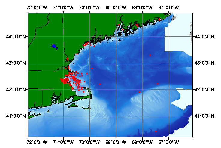
- Browse_Graphic:
-
- Browse_Graphic_File_Name: gomcsdb
- Browse_Graphic_File_Description:
-
Image map showing extent and distribution of data layer coverage.
- Browse_Graphic_File_Type: GIF
- Data_Set_Credit:
-
Please review the cross reference information for the original data set credit to Buchholtz ten Brink and others (2002), and Larry Poppe for creating this ArcView shapefile.
- Native_Data_Set_Environment:
-
Microsoft Windows 2000 Version 5.1 (Build 2600) ; ESRI ArcCatalog 8.2.0.700
- Cross_Reference:
-
- Citation_Information:
-
- Originator: M.R. Buchholtz ten Brink
- Originator: F.T. Manheim
- Originator: E.L. Mecray
- Originator: M.E. Hastings
- Originator: J.M. Currence
- Originator: J.W. Farrington
- Originator: S.H. Jones
- Originator: P.F. Larsen
- Originator: B.W. Tripp
- Originator: G.T. Wallace
- Originator: L.G. Ward
- Originator: T.J. Freddette
- Originator: M.L. Liebman
- Originator: W. Smith Leo
- Publication_Date: 2002
- Title: Contaminated Sediments Database for the Gulf of Maine
- Edition: 1.0
- Series_Information:
-
- Series_Name: U.S. Geolgical Survey Open-File Report
- Issue_Identification: 02-403
- Publication_Information:
-
- Publication_Place: Woods Hole, MA
- Publisher: U.S. Geological Survey
- Data_Quality_Information:
-
- Attribute_Accuracy:
-
- Attribute_Accuracy_Report:
-
All attributes were checked by compilers in a consistent manner.
- Logical_Consistency_Report:
-
No additional checks for topological consistency were performed on this data.
- Completeness_Report:
-
Sample locations, grain-size data, textural classifications, and sample identifiers are provided for 852 stations.
- Positional_Accuracy:
-
- Horizontal_Positional_Accuracy:
-
- Horizontal_Positional_Accuracy_Report:
-
Navigation was by several methods; navigational accuracy unknown.
- Lineage:
-
- Source_Information:
-
- Source_Citation:
-
- Citation_Information:
-
- Originator: M.R. Buchholtz ten Brink
- Originator: F.T. Manheim
- Originator: E.L. Mecray
- Originator: M.E. Hastings
- Originator: J.M. Currence
- Originator: J. Farrington
- Originator: S. Jones
- Originator: B. Tripp
- Originator: G. Wallace
- Originator: L. Ward
- Originator: T. Freddette
- Originator: M. Liebman
- Originator: W. Smith Leo
- Publication_Date: 2002
- Title: Contaminated Sediments Database for the Gulf of Maine
- Edition: 1.0
- Series_Information:
-
- Series_Name: U.S. Geological Survey Open-File Report
- Issue_Identification: 02-403
- Publication_Information:
-
- Publication_Place: Woods Hole, MA
- Publisher: U.S. Geological Survey
- Type_of_Source_Media: CD-ROM
- Process_Step:
-
- Process_Description:
-
Textural and lithologic data from the Gulf of Maine were clipped from the whole Gulf of Maine Contaminated Sediments Database in Excel and exported to an ASCII file. Stations and sediment data were imported from the ASCII text file to an ArcView table. The table was later converted to an event theme and saved as the final shapefile.
- Source_Used_Citation_Abbreviation: gomcsdb.txt
- Process_Date: 20021204
- Source_Produced_Citation_Abbreviation: gomcsdb.shp
- Source_Produced_Citation_Abbreviation: gomcsdb.shx
- Source_Produced_Citation_Abbreviation: gomcsdb.shp
- Process_Contact:
-
- Contact_Information:
-
- Contact_Person_Primary:
-
- Contact_Person: Lawrence J. Poppe
- Contact_Organization: U.S. Geological Survey
- Contact_Position: Geologist
- Contact_Address:
-
- Address_Type: mailing and physical address
- Address: 384 Woods Hole Road
- City: Woods Hole
- State_or_Province: MA
- Postal_Code: 02543-1598
- Country: USA
- Contact_Voice_Telephone: 508-548-8700 x2314
- Contact_Facsimile_Telephone: 508-457-2310
- Contact_Electronic_Mail_Address: [email protected]
- Spatial_Data_Organization_Information:
-
- Direct_Spatial_Reference_Method: Vector
- Point_and_Vector_Object_Information:
-
- SDTS_Terms_Description:
-
- SDTS_Point_and_Vector_Object_Type: Entity point
- Point_and_Vector_Object_Count: 852
- Spatial_Reference_Information:
-
- Horizontal_Coordinate_System_Definition:
-
- Geographic:
-
- Latitude_Resolution: 0.00001
- Longitude_Resolution: 0.00001
- Geographic_Coordinate_Units: Decimal degrees
- Geodetic_Model:
-
- Horizontal_Datum_Name: North American Datum of 1927
- Ellipsoid_Name: Clarke 1866
- Semi-major_Axis: 6378206.400000
- Denominator_of_Flattening_Ratio: 294.978698
- Entity_and_Attribute_Information:
-
- Detailed_Description:
-
- Entity_Type:
-
- Entity_Type_Label: gomcsdb.dbf
- Entity_Type_Definition: Shapefile Attribute Table
- Entity_Type_Definition_Source: ESRI
- Attribute:
-
- Attribute_Label: FID
- Attribute_Definition: Internal feature number.
- Attribute_Definition_Source: ESRI
- Attribute_Domain_Values:
-
- Unrepresentable_Domain:
-
Sequential unique whole numbers that are automatically generated.
- Attribute:
-
- Attribute_Label: Shape
- Attribute_Definition: Feature geometry.
- Attribute_Definition_Source: ESRI
- Attribute_Domain_Values:
-
- Unrepresentable_Domain: Coordinates defining the features.
- Attribute:
-
- Attribute_Label: USGSDB_ID
- Attribute_Definition: Characters and numerics assigned to identify individual samples
- Attribute_Definition_Source: Database Compilers
- Attribute_Domain_Values:
-
- Unrepresentable_Domain: Sample identifiers
- Attribute:
-
- Attribute_Label: FIELD_ID
- Attribute_Definition: Names assigned in the field to identify samples
- Attribute_Definition_Source: Scientist
- Attribute_Domain_Values:
-
- Unrepresentable_Domain: Sample identifiers
- Attribute:
-
- Attribute_Label: LATITUDE
- Attribute_Definition: Latitude coordinate of sample location
- Attribute_Definition_Source: Scientist
- Attribute_Domain_Values:
-
- Range_Domain:
-
- Range_Domain_Minimum: 40.40000
- Range_Domain_Maximum: 44.67800
- Attribute_Units_of_Measure: Decimal degrees
- Attribute_Measurement_Resolution: 0.00001
- Attribute:
-
- Attribute_Label: LONGITUDE
- Attribute_Definition: Longitude coordinate of sample location
- Attribute_Definition_Source: Scientist
- Attribute_Domain_Values:
-
- Range_Domain:
-
- Range_Domain_Minimum: -71.10000
- Range_Domain_Maximum: -67.33500
- Attribute_Units_of_Measure: Decimal degrees
- Attribute_Measurement_Resolution: 0.00001
- Attribute:
-
- Attribute_Label: SOURCE
- Attribute_Definition: Source citation
- Attribute_Definition_Source: Database compiler
- Attribute_Domain_Values:
-
- Unrepresentable_Domain: Authors, year published, and ancillary information
- Attribute:
-
- Attribute_Label: YEAR
- Attribute_Definition: Year samples were collected
- Attribute_Definition_Source: Scientist
- Attribute_Domain_Values:
-
- Range_Domain:
-
- Range_Domain_Minimum: 1970
- Range_Domain_Maximum: 1993
- Attribute_Units_of_Measure: years
- Attribute_Measurement_Resolution: 1
- Attribute:
-
- Attribute_Label: DEVICE
- Attribute_Definition: Equipment used to collect samples
- Attribute_Definition_Source: Scientist
- Attribute_Domain_Values:
-
- Unrepresentable_Domain: Equipment used to collect samples
- Attribute:
-
- Attribute_Label: DPTH_CODE
- Attribute_Definition:
-
Description of the depth interval of sample below the sediment - water interface
- Attribute_Definition_Source: Database compiler
- Attribute_Domain_Values:
-
- Unrepresentable_Domain: Descriptions of the sampling interval
- Attribute:
-
- Attribute_Label: LITHOLOGY
- Attribute_Definition: Description of the bottom sediments
- Attribute_Definition_Source: Scientists
- Attribute_Domain_Values:
-
- Unrepresentable_Domain: Verbal description of the bottom sediments
- Attribute:
-
- Attribute_Label: GRAVEL
- Attribute_Definition: Percentage of gravel in sample
- Attribute_Definition_Source: Scientist
- Attribute_Domain_Values:
-
- Range_Domain:
-
- Range_Domain_Minimum: 0
- Range_Domain_Maximum: 86.44
- Attribute_Units_of_Measure: percent
- Attribute_Measurement_Resolution: 0.00
- Attribute:
-
- Attribute_Label: SAND
- Attribute_Definition: Percentage of sand in sample
- Attribute_Definition_Source: Scientist
- Attribute_Domain_Values:
-
- Range_Domain:
-
- Range_Domain_Minimum: 1
- Range_Domain_Maximum: 100
- Attribute_Units_of_Measure: percent
- Attribute_Measurement_Resolution: 0.00
- Attribute:
-
- Attribute_Label: SILT
- Attribute_Definition: Percentage of silt in sample
- Attribute_Domain_Values:
-
- Range_Domain:
-
- Range_Domain_Minimum: 0
- Range_Domain_Maximum: 72
- Attribute_Units_of_Measure: percent
- Attribute_Measurement_Resolution: 0.00
- Attribute:
-
- Attribute_Label: CLAY
- Attribute_Definition: Percentage of clay in sample
- Attribute_Definition_Source: Scientist
- Attribute_Domain_Values:
-
- Range_Domain:
-
- Range_Domain_Minimum: 0
- Range_Domain_Maximum: 69.3
- Attribute_Units_of_Measure: percent
- Attribute_Measurement_Resolution: 0.00
- Attribute:
-
- Attribute_Label: FINES
- Attribute_Definition: Percentage of fines in sample
- Attribute_Definition_Source: Scientist
- Attribute_Domain_Values:
-
- Range_Domain:
-
- Range_Domain_Minimum: 0
- Range_Domain_Maximum: 99
- Attribute_Units_of_Measure: percent
- Attribute_Measurement_Resolution: 0.00
- Attribute:
-
- Attribute_Label: CLASS
- Attribute_Definition:
-
Textural classification based on a scheme devised by Shepard (1954)
- Attribute_Definition_Source: Compiler
- Attribute_Domain_Values:
-
- Unrepresentable_Domain: Verbal description of the sediment texture
- Distribution_Information:
-
- Distributor:
-
- Contact_Information:
-
- Contact_Person_Primary:
-
- Contact_Person: Lawrence J. Poppe
- Contact_Organization: U.S. Geological Survey
- Contact_Position: Geologist
- Contact_Address:
-
- Address_Type: mailing and physical address
- Address: 384 Woods Hole Road
- City: Woods Hole
- State_or_Province: MA
- Postal_Code: 02543-1598
- Country: USA
- Contact_Voice_Telephone: 508-548-8700 x2314
- Contact_Facsimile_Telephone: 508-457-2310
- Contact_Electronic_Mail_Address: [email protected]
- Resource_Description:
-
Regional Mapping of Surficial Sediments: Gulf of Maine and Georges Bank, Aggregates and Habitats Projects, gomcsdb.shp
- Distribution_Liability:
-
Although this data set has been used by the U.S. Geological Survey, no warranty, expressed or implied, is made by the USGS as to the accuracy of the data and/or related materials. The act of distribution shall not constitute any such warranty, and no responsibility is assumed by the USGS in the use of these data or related materials.
- Standard_Order_Process:
-
- Digital_Form:
-
- Digital_Transfer_Information:
-
- Format_Name: ArcView shapefile
- Format_Version_Number: 3.2
- Format_Specification: ESRI point shapefile
- Format_Information_Content:
-
Five files (gomcsdb.shp, gomcsdb.dbf, gomcsdb.shx, gomcsdb.sbx, gomcsdb.sbn) comprising the ArcView point shapefile components, 'prj' and 'avl' files, metadata text file and browse graphic.
- File_Decompression_Technique: zip
- Transfer_Size: 0.651
- Digital_Transfer_Option:
-
- Offline_Option:
-
- Offline_Media: CD-ROM
- Recording_Capacity:
-
- Recording_Density: 650
- Recording_Density_Units: Mbytes
- Compatibility_Information:
-
The user must have a computer system with a CD-ROM available. To browse the information contained on this CD-ROM, the user must have a current WWW browser available. The user must also have software installed on their computer to unzip the archived file.
- Fees: None
- Technical_Prerequisites:
-
The data is available in ArcView shapefile format. The user must have ArcView 3.0 or greater software to read and process the data file. In lieu of ArcView, the user may utilize another GIS application package capable of importing data.
- Metadata_Reference_Information:
-
- Metadata_Date: 20030216
- Metadata_Contact:
-
- Contact_Information:
-
- Contact_Person_Primary:
-
- Contact_Person: Lawrence J. Poppe
- Contact_Organization: U.S. Geological Survey
- Contact_Position: Geologist
- Contact_Address:
-
- Address_Type: mailing and physical address
- Address: 384 Woods Hole Road
- City: Woods Hole
- State_or_Province: MA
- Postal_Code: 02543-1598
- Country: USA
- Contact_Voice_Telephone: 508-548-8700 x2314
- Contact_Facsimile_Telephone: 508-457-2310
- Contact_Electronic_Mail_Address: [email protected]
- Metadata_Standard_Name: FGDC Content Standards for Digital Geospatial Metadata
- Metadata_Standard_Version: FGDC-STD-001-1998
- Metadata_Time_Convention: local time
- Metadata_Access_Constraints: None
- Metadata_Use_Constraints: None
Generated by mp version 2.7.3 on Sun Feb 16 12:00:09 2003
OFR03-001 Home | Introduction
| Nomenclature | Browse
Maps | Data Catalog | Data
Dictionary
[an error occurred while processing this directive]