|
 |
| U.S. Geological Survey
Open-File Report 03-001 |
|
|
MCMASTER60: Sediments of Narragansett Bay
|
Metadata also available as: FAQ - TEXT
Metadata:
- Identification_Information:
-
- Citation:
-
- Citation_Information:
-
- Originator: Lawrence J. Poppe
- Publication_Date: 2003
- Title: MCMASTER60: Sediments of Narragansett Bay
- Edition: 1.0
- Geospatial_Data_Presentation_Form: vector digital data
- Series_Information:
- Publication_Information:
-
- Publication_Place: Woods Hole Field Center, Woods Hole, MA
- Publisher: U. S. Geological Survey, Coastal and Marine Geology Program
- Online_Linkage:
-
<http://pubs.usgs.gov/of/2003/of03-001/data/seddata/mcmaster60/mcmaster60.zip>
- Online_Linkage:
-
<http://pubs.usgs.gov/of/2003/of03-001/data/seddata/mcmaster60/mcmaster60.zip>
- Larger_Work_Citation:
-
- Citation_Information:
-
- Originator: L.J. Poppe
- Originator: V.F. Paskevich
- Originator: S.J. Williams
- Originator: M.E. Hastings
- Originator: J.T. Kelley
- Originator: D.F. Belknap
- Originator: L.G. Ward
- Originator: D.M. FitzGerald
- Originator: P.F. Larsen
- Publication_Date: 2003
- Title:
-
Surficial Sediment Data from the Gulf of Maine, Georges Bank, and vicinity: a GIS Compilation
- Edition: 1.0
- Series_Information:
-
- Series_Name: Open-File Report
- Issue_Identification: 03-001
- Publication_Information:
-
- Publication_Place: Woods Hole Field Center, Woods Hole, MA
- Publisher: U. S. Geological Survey, Coastal and Marine Geology Program
- Other_Citation_Details:
-
Data is released via CD-ROM media. This digital publication may also be available via the web at pubs.usgs.gov
- Online_Linkage: <http://pubs.usgs.gov/of/2003/of03-001>
- Online_Linkage: <http://pubs.usgs.gov/of/2003/of03-001>
- Description:
-
- Abstract:
-
Gravel, sand, silt, and clay contents were determined for samples from Narragansett Bay and the adjacent Rhode Island Shelf. In the Narragansett Bay system, clayey silt and sand-silt-clay are the most abundant sediments. Sand is abundant locally and on the inner shelf. In general, toward the lower passages of the Bay the sediments show a progressive change to coarser textures.
- Purpose:
-
The purpose of this data layer is to release a digital version of the sediment data used in the interpretations published by McMaster (1960).
- Time_Period_of_Content:
-
- Time_Period_Information:
-
- Single_Date/Time:
-
- Calendar_Date: 1960
- Currentness_Reference: publication date
- Status:
-
- Progress: Complete
- Maintenance_and_Update_Frequency: None planned
- Spatial_Domain:
-
- Bounding_Coordinates:
-
- West_Bounding_Coordinate: -71.441700
- East_Bounding_Coordinate: -71.162000
- North_Bounding_Coordinate: 41.766700
- South_Bounding_Coordinate: 41.434000
- Keywords:
-
- Theme:
-
- Theme_Keyword_Thesaurus: General
- Theme_Keyword: U.S. Geological Survey
- Theme_Keyword: Coastal and Marine Geology
- Theme_Keyword: Coastal and Marine Geology Program
- Theme_Keyword: Woods Hole Field Center
- Theme_Keyword: ArcView
- Theme_Keyword: GIS
- Theme_Keyword: sediment
- Theme_Keyword: gravel
- Theme_Keyword: sand
- Theme_Keyword: silt
- Theme_Keyword: clay
- Theme_Keyword: texture
- Theme_Keyword: National Assessment of Marine Sand and Gravel Resources
- Theme_Keyword: Open-File Report 03-001
- Theme_Keyword: CMGP
- Theme_Keyword: sediment classification
- Theme_Keyword: surficial classification
- Theme_Keyword: ArcView shapefile
- Theme_Keyword: points
- Theme_Keyword: Geographic Information System
- Place:
-
- Place_Keyword_Thesaurus: General
- Place_Keyword: U.S. East Coast
- Place_Keyword: Narragansett Bay
- Place_Keyword: New England
- Place_Keyword: Atlantic
- Place_Keyword: Rhode Island
- Place_Keyword: Providence, RI
- Place_Keyword: Mount Hope Bay
- Place_Keyword: Greenwich Bay
- Access_Constraints: None
- Use_Constraints: None
- Point_of_Contact:
-
- Contact_Information:
-
- Contact_Person_Primary:
-
- Contact_Person: Lawrence J. Poppe
- Contact_Organization: U.S. Geologcal Survey
- Contact_Position: Geologist
- Contact_Address:
-
- Address_Type: mailing and physical address
- Address: 384 Woods Hole Road
- City: Woods Hole
- State_or_Province: MA
- Postal_Code: 02543-1598
- Country: USA
- Contact_Voice_Telephone: 508-548-8700 x2314
- Contact_Facsimile_Telephone: 508-457-2310
- Contact_Electronic_Mail_Address: lpoppe@usgs.gov
- Browse_Graphic:
-
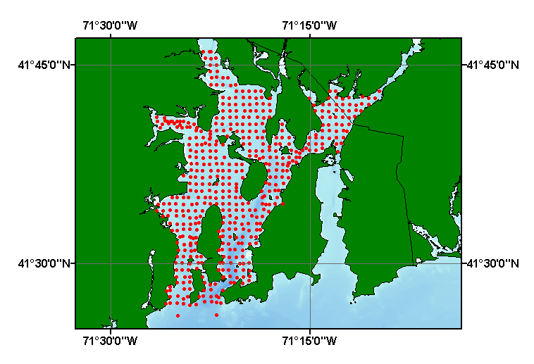
- Browse_Graphic_File_Name: mcmaster60
- Browse_Graphic_File_Description:
-
Image map showing extent and distribution of data layer coverage.
- Browse_Graphic_File_Type: GIF
- Data_Set_Credit:
-
Please review the cross reference information for the original data set credit to R.L. McMaster. Larry Poppe for entering the data from the source report and creating the ArcView shapefile.
- Native_Data_Set_Environment:
-
Microsoft Windows 2000 Version 5.1 (Build 2600) ; ESRI ArcCatalog 8.2.0.700
- Cross_Reference:
-
- Citation_Information:
-
- Originator: R.L. McMaster
- Publication_Date: 1960
- Title:
-
Sediments of Narragansett Bay and Rhode Island Sound, Rhode Island
- Edition: 1.0
- Series_Information:
-
- Series_Name: Journal of Sedimentary Petrology
- Issue_Identification: v. 30, no. 2, p. 249-274.
- Data_Quality_Information:
-
- Attribute_Accuracy:
-
- Attribute_Accuracy_Report:
-
All attributes were entered and checked by compilers in a consistent manner.
- Logical_Consistency_Report:
-
No additional checks for topological consistency were performed on this data.
- Completeness_Report:
-
Sample locations and textural data are provided for 493 stations.
- Positional_Accuracy:
-
- Horizontal_Positional_Accuracy:
-
- Horizontal_Positional_Accuracy_Report:
-
The navigational methods used to position the stations are not discussed in the source text. Horizontal accuracy is unknown.
- Vertical_Positional_Accuracy:
-
- Vertical_Positional_Accuracy_Report: Tides are less than 2 m.
- Quantitative_Vertical_Positional_Accuracy_Assessment:
-
- Vertical_Positional_Accuracy_Value: 2
- Lineage:
-
- Source_Information:
-
- Source_Citation:
-
- Citation_Information:
-
- Originator: R.L. McMaster
- Publication_Date: 1960
- Title:
-
Sediments of Narragansett Bay and Rhode Island Sound, Rhode Island
- Edition: 1.0
- Series_Information:
-
- Series_Name: Journal of Sedimentary Petrology
- Issue_Identification: v. 30, no. 2, p. 249-274.
- Type_of_Source_Media: paper
- Process_Step:
-
- Process_Description:
-
The source information was manually entered into digital form and was imported from an ASCII text file to an ArcView table. The table was later converted into an event theme in ArcView and saved as the final shapefile
- Source_Used_Citation_Abbreviation: mcmaster60.txt
- Process_Date: 20020905
- Source_Produced_Citation_Abbreviation: mcmaster60.shp
- Source_Produced_Citation_Abbreviation: mcmaster60.dbf
- Source_Produced_Citation_Abbreviation: mcmaster60.shx
- Process_Contact:
-
- Contact_Information:
-
- Contact_Person_Primary:
-
- Contact_Person: Lawrence J. Poppe
- Contact_Organization: U.S. Geological Survey
- Contact_Position: Geologist
- Contact_Address:
-
- Address_Type: mailing and physical address
- Address: 384 Woods Hole road
- City: Woods Hole
- State_or_Province: MA
- Postal_Code: 02543-1598
- Country: USA
- Contact_Voice_Telephone: 508-548-8700 x2314
- Contact_Facsimile_Telephone: 508-457-2310
- Contact_Electronic_Mail_Address: lpoppe@usgs.gov
- Spatial_Data_Organization_Information:
-
- Direct_Spatial_Reference_Method: Vector
- Point_and_Vector_Object_Information:
-
- SDTS_Terms_Description:
-
- SDTS_Point_and_Vector_Object_Type: Entity point
- Point_and_Vector_Object_Count: 493
- Spatial_Reference_Information:
-
- Horizontal_Coordinate_System_Definition:
-
- Geographic:
-
- Latitude_Resolution: 0.0001
- Longitude_Resolution: 0.0001
- Geographic_Coordinate_Units: Decimal degrees
- Geodetic_Model:
-
- Horizontal_Datum_Name: North American Datum of 1927
- Ellipsoid_Name: Clarke 1866
- Semi-major_Axis: 6378206.400000
- Denominator_of_Flattening_Ratio: 294.978698
- Entity_and_Attribute_Information:
-
- Detailed_Description:
-
- Entity_Type:
-
- Entity_Type_Label: mcmaster60.dbf
- Entity_Type_Definition: Shapefile Attribute Table
- Entity_Type_Definition_Source: ESRI
- Attribute:
-
- Attribute_Label: FID
- Attribute_Definition: Internal feature number.
- Attribute_Definition_Source: ESRI
- Attribute_Domain_Values:
-
- Unrepresentable_Domain:
-
Sequential unique whole numbers that are automatically generated.
- Attribute:
-
- Attribute_Label: Shape
- Attribute_Definition: Feature geometry.
- Attribute_Definition_Source: ESRI
- Attribute_Domain_Values:
-
- Unrepresentable_Domain: Coordinates defining the features.
- Attribute:
-
- Attribute_Label: PROJECTID
- Attribute_Definition: Project ID assigned to the dataset for future identification.
- Attribute_Definition_Source: Compiler
- Attribute_Domain_Values:
-
- Enumerated_Domain:
-
- Enumerated_Domain_Value: MCMASTER1960
- Enumerated_Domain_Value_Definition: Scientist and year of publication
- Enumerated_Domain_Value_Definition_Source: Compiler
- Attribute:
-
- Attribute_Label: AREA
- Attribute_Definition: Geographic area where samples were collected.
- Attribute_Definition_Source: Compiler
- Attribute_Domain_Values:
-
- Enumerated_Domain:
-
- Enumerated_Domain_Value: NARRAGANSETT BAY
- Enumerated_Domain_Value_Definition_Source: Compiler
- Attribute:
-
- Attribute_Label: SAMPLE
- Attribute_Definition: Station where sample was collected
- Attribute_Definition_Source: Scientist
- Attribute_Domain_Values:
-
- Unrepresentable_Domain: Numerics and characters designating a station
- Attribute:
-
- Attribute_Label: LATITUDE
- Attribute_Definition: Latitude coordinate of sample location
- Attribute_Definition_Source: Data Compiler
- Attribute_Domain_Values:
-
- Range_Domain:
-
- Range_Domain_Minimum: 41.4340
- Range_Domain_Maximum: 41.7667
- Attribute_Units_of_Measure: Decimal Degrees
- Attribute_Measurement_Resolution: 0.0001
- Attribute:
-
- Attribute_Label: LONGITUDE
- Attribute_Definition: Longitude of sample location
- Attribute_Definition_Source: Data Compiler
- Attribute_Domain_Values:
-
- Range_Domain:
-
- Range_Domain_Minimum: -714417
- Range_Domain_Maximum: -71.1620
- Attribute_Units_of_Measure: Decimal Degrees
- Attribute_Measurement_Resolution: 0.0001
- Attribute:
-
- Attribute_Label: GRAVEL
- Attribute_Definition: Percentage of gravel in the sample
- Attribute_Definition_Source: Scientist
- Attribute_Domain_Values:
-
- Range_Domain:
-
- Range_Domain_Minimum: 0
- Range_Domain_Maximum: 100
- Attribute_Units_of_Measure: percent
- Attribute_Measurement_Resolution: 0.1
- Attribute:
-
- Attribute_Label: SAND
- Attribute_Definition: Percentage of sand in the sample
- Attribute_Definition_Source: Scientist
- Attribute_Domain_Values:
-
- Range_Domain:
-
- Range_Domain_Minimum: 0
- Range_Domain_Maximum: 98.6
- Attribute_Units_of_Measure: percent
- Attribute_Measurement_Resolution: 0.1
- Attribute:
-
- Attribute_Label: SILT
- Attribute_Definition: Percentage of silt in the sample
- Attribute_Definition_Source: Scientist
- Attribute_Domain_Values:
-
- Range_Domain:
-
- Range_Domain_Minimum: 0
- Range_Domain_Maximum: 83.7
- Attribute_Units_of_Measure: percent
- Attribute_Measurement_Resolution: 0.1
- Attribute:
-
- Attribute_Label: CLAY
- Attribute_Definition: Percentage of clay in the sample
- Attribute_Definition_Source: Scientist
- Attribute_Domain_Values:
-
- Range_Domain:
-
- Range_Domain_Minimum: 0
- Range_Domain_Maximum: 38.5
- Attribute_Units_of_Measure: percent
- Attribute_Measurement_Resolution: 0.1
- Attribute:
-
- Attribute_Label: SHEPARD_CL
- Attribute_Definition:
-
Sediment classification based on the scheme described by Shepard (1954)
- Attribute_Definition_Source: Compiler
- Attribute_Domain_Values:
-
- Unrepresentable_Domain:
-
Character string containing textural description based on Shephard's classification scheme
- Attribute_Domain_Values:
-
- Enumerated_Domain:
-
- Enumerated_Domain_Value: CLAYEY SILT
- Enumerated_Domain_Value_Definition: clayey silt content
- Enumerated_Domain_Value_Definition_Source: Visual examination of sample by scientist
- Enumerated_Domain:
-
- Enumerated_Domain_Value: GRAVEL
- Enumerated_Domain_Value_Definition: gravel content
- Enumerated_Domain_Value_Definition_Source: Visual examination of sample by scientist
- Enumerated_Domain:
-
- Enumerated_Domain_Value: GRAVELLY SEDIMENT
- Enumerated_Domain_Value_Definition: gravelly sediment content
- Enumerated_Domain_Value_Definition_Source: Visual examination of sample by scientist
- Enumerated_Domain:
-
- Enumerated_Domain_Value: SAND
- Enumerated_Domain_Value_Definition: sand content
- Enumerated_Domain_Value_Definition_Source: Visual examination of sample by scientist
- Enumerated_Domain:
-
- Enumerated_Domain_Value: SAND SILT CLAY
- Enumerated_Domain_Value_Definition: sand silt clay content
- Enumerated_Domain_Value_Definition_Source: Visual examination of sample by scientist
- Enumerated_Domain:
-
- Enumerated_Domain_Value: SANDY SILT
- Enumerated_Domain_Value_Definition: sandy silt content
- Enumerated_Domain_Value_Definition_Source: Visual examination of sample by scientist
- Enumerated_Domain:
-
- Enumerated_Domain_Value: SILT
- Enumerated_Domain_Value_Definition: silt content
- Enumerated_Domain_Value_Definition_Source: Visual examination of sample by scientist
- Enumerated_Domain:
-
- Enumerated_Domain_Value: SILTY SAND
- Enumerated_Domain_Value_Definition: silty sand content
- Enumerated_Domain_Value_Definition_Source: Visual examination of sample by scientist
- Overview_Description:
-
- Entity_and_Attribute_Overview:
-
Grain size data, textural classification, navigation, and identifiers for grab samples collected and published by R.L. McMaster
- Distribution_Information:
-
- Distributor:
-
- Contact_Information:
-
- Contact_Person_Primary:
-
- Contact_Person: Lawrence J. Poppe
- Contact_Organization: U.S. Geological Survey
- Contact_Position: Geologist
- Contact_Address:
-
- Address_Type: mailing and physical address
- Address: 384 Woods Hole Road
- City: Woods Hole
- State_or_Province: MA
- Postal_Code: 02543-1598
- Country: USA
- Contact_Voice_Telephone: 508-548-8700 x2314
- Contact_Facsimile_Telephone: 508-457-2310
- Contact_Electronic_Mail_Address: lpoppe@usgs.gov
- Resource_Description:
-
Regional Mapping of Surficial Sediments: Gulf of Maine and Georges Bank, Aggregates and Habitats Projects, mcmaster60.shp
- Distribution_Liability:
-
Although this dataset has been used by the U.S. Geological Survey, no warranty, expressed or implied, is made by the USGS as to the accuracy of the data and/or related materials. The act of distribution shall not constitute any such warranty, and no responsibility is assumed by the USGS in the use of these data or materials.
- Standard_Order_Process:
-
- Digital_Form:
-
- Digital_Transfer_Information:
-
- Format_Name: ArcView shapefile
- Format_Version_Number: 3.2
- Format_Specification: ESRI point shapefile
- Format_Information_Content:
-
Five files (mcmaster60.shp, mcmaster60.dbf, mcmaster60.shx, mcmaster60.sbx, mcmaster60.sbn) comprising the ArcView point shapefile components, 'prj' and 'avl' files, metadata text file and browse graphic.
- File_Decompression_Technique: zip
- Transfer_Size: 0.201
- Digital_Transfer_Option:
-
- Offline_Option:
-
- Offline_Media: CD-ROM
- Recording_Capacity:
-
- Recording_Density: 650
- Recording_Density_Units: Mbytes
- Compatibility_Information:
-
The user must have a computer system with a CD-ROM available. To browse the information contained on this CD-ROM, the user must have a current WWW browser available. The user must also have software installed on their computer to unzip the archived file.
- Fees: None
- Technical_Prerequisites:
-
The data is available in ArcView shapefile format. The user must have ESRI's ArcView 3.0 or greater software to read and process the data file. In lieu of ArcView, the user may utilize another GIS application package capable of importing the data
- Available_Time_Period:
-
- Time_Period_Information:
-
- Single_Date/Time:
-
- Calendar_Date: 2002
- Metadata_Reference_Information:
-
- Metadata_Date: 20030324
- Metadata_Contact:
-
- Contact_Information:
-
- Contact_Person_Primary:
-
- Contact_Person: Lawrence J. Poppe
- Contact_Organization: U.S. Geological Survey
- Contact_Position: Geologist
- Contact_Address:
-
- Address_Type: mailing and physical address
- Address: 384 Woods Hole Road
- City: Woods Hole
- State_or_Province: MA
- Postal_Code: 02543-1598
- Country: USA
- Contact_Voice_Telephone: 508-548-8700 x2314
- Contact_Facsimile_Telephone: 508-457-2310
- Contact_Electronic_Mail_Address: lpoppe@usgs.gov
- Metadata_Standard_Name: FGDC Content Standards for Digital Geospatial Metadata
- Metadata_Standard_Version: FGDC-STD-001-1998
- Metadata_Time_Convention: local time
- Metadata_Access_Constraints: None
- Metadata_Use_Constraints: None
Generated by mp version 2.7.3 on Mon Mar 24 08:50:46 2003
OFR03-001 Home | Introduction
| Nomenclature | Browse
Maps | Data Catalog | Data
Dictionary
[an error occurred while processing this directive]