|
 |
| U.S. Geological Survey
Open-File Report 03-001 |
|
|
MNHACOE: Army Corps Sediment Data from Maine and New Hampshire
|
Metadata also available as: FAQ - TEXT
Metadata:
- Identification_Information:
-
- Citation:
-
- Citation_Information:
-
- Originator: Walter Barnhardt
- Originator: Polly Hastings
- Originator: Lawrence J. Poppe
- Publication_Date: 2003
- Title: MNHACOE: Army Corps Sediment Data from Maine and New Hampshire
- Edition: 1.0
- Geospatial_Data_Presentation_Form: vector digital data
- Publication_Information:
-
- Publication_Place: Woods Hole Field Center, Woods Hole, MA
- Publisher: U.S. Geological Survey, Coastal and Marine Geology Program
- Online_Linkage:
-
<http://pubs.usgs.gov/of/2003/of03-001/data/seddata/mnhacoe/mnhacoe.zip>
- Online_Linkage:
-
<http://pubs.usgs.gov/of/2003/of03-001/data/seddata/mnhacoe/mnhacoe.zip>
- Larger_Work_Citation:
-
- Citation_Information:
-
- Originator: L.J. Poppe
- Originator: V.F. Paskevich
- Originator: S.J. Williams
- Originator: M.E. Hastings
- Originator: J.T. Kelley
- Originator: D.F. Belknap
- Originator: L.G. Ward
- Originator: D.M. FitzGerald
- Originator: P.F. Larsen
- Publication_Date: 2003
- Title:
-
Surficial Sediment Data from the Gulf of Maine, Georges Bank, and vicinity: a GIS Compilation
- Edition: 1.0
- Series_Information:
-
- Series_Name: Open-File Report
- Issue_Identification: 03-001
- Publication_Information:
-
- Publication_Place: Woods Hole Field Center, Woods Hole, MA
- Publisher: U.S. Geological Survey, Coastal and Marine Geology Program
- Other_Citation_Details:
-
Data are released via CD-ROM media. This digital publication may also be available via the web at pubs.usgs.gov
- Online_Linkage: <http://pubs.usgs.gov/of/2003/of03-001>
- Online_Linkage: <http://pubs.usgs.gov/of/2003/of03-001>
- Description:
-
- Abstract:
-
The data in this layer are from a study that evaluated and documented the historic and projected future dredging and dredged material disposal needs of the coastal rivers and harbors of the states of Maine and New Hampshire. Documentation of historic dredging and disposal activities was accomplished through the collection of data primarily from the files of the ACOE, New England Division, in Waltham, Massachusetts, supplemented by information from the states of
Maine and New Hampshire and previously published reports. This historic dredging occurred between 1950-1993 and involved 499 dredging events.
- Purpose:
-
The purpose of this data layer is to release a digital version of the sediment data published in Normandeau Associates (1994).
- Time_Period_of_Content:
-
- Time_Period_Information:
-
- Single_Date/Time:
-
- Calendar_Date: 1994
- Currentness_Reference: publication date
- Status:
-
- Progress: Complete
- Maintenance_and_Update_Frequency: None planned
- Spatial_Domain:
-
- Bounding_Coordinates:
-
- West_Bounding_Coordinate: -70.824170
- East_Bounding_Coordinate: -67.371630
- North_Bounding_Coordinate: 44.800000
- South_Bounding_Coordinate: 42.888180
- Keywords:
-
- Theme:
-
- Theme_Keyword_Thesaurus: General
- Theme_Keyword: U.S. Geological Survey
- Theme_Keyword: USGS
- Theme_Keyword: USACOE
- Theme_Keyword: ACOE
- Theme_Keyword: Army Corps of Engineers
- Theme_Keyword: sediment
- Theme_Keyword: texture
- Theme_Keyword: grain size
- Theme_Keyword: gravel
- Theme_Keyword: sand
- Theme_Keyword: silt
- Theme_Keyword: clay
- Theme_Keyword: fines
- Theme_Keyword: Open-File Report 03-001
- Theme_Keyword: Woods Hole Field Center
- Theme_Keyword: Coastal and Marine Geology Program
- Theme_Keyword: CMGP
- Theme_Keyword: sediment classification
- Theme_Keyword: surficial classification
- Theme_Keyword: ArcView shapefile
- Theme_Keyword: points
- Theme_Keyword: GIS
- Place:
-
- Place_Keyword_Thesaurus: General
- Place_Keyword: U.S. East Coast
- Place_Keyword: New England
- Place_Keyword: Maine
- Place_Keyword: New Hampshire
- Place_Keyword: Atlantic
- Place_Keyword: Continental Shelf
- Access_Constraints: None
- Use_Constraints: None
- Point_of_Contact:
-
- Contact_Information:
-
- Contact_Person_Primary:
-
- Contact_Person: Lawrence J. Poppe
- Contact_Organization: U.S. Geological Survey
- Contact_Position: Geologist
- Contact_Address:
-
- Address_Type: mailing and physical address
- Address: 384 Woods Hole Road
- City: Woods Hole
- State_or_Province: MA
- Postal_Code: 02543-1598
- Country: USA
- Contact_Voice_Telephone: 508-548-8700 x2314
- Contact_Facsimile_Telephone: 508-457-2310
- Contact_Electronic_Mail_Address: lpoppe@usgs.gov
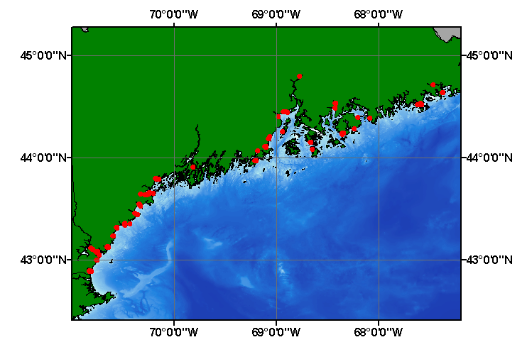
- Browse_Graphic:
-
- Browse_Graphic_File_Name: mnhacoe
- Browse_Graphic_File_Description:
-
Image map showing extent and distribution of data layer coverage.
- Browse_Graphic_File_Type: GIF
- Data_Set_Credit:
-
Please review the cross section information for the original data set credit to Normandeau Associates (1994). Walter Barnhardt for entering the data from the source report and Larry Poppe for creating the ArcView shapefile.
- Native_Data_Set_Environment:
-
Microsoft Windows 2000 Version 5.1 (Build 2600) ; ESRI ArcCatalog 8.2.0.700
- Cross_Reference:
-
- Citation_Information:
-
- Originator: Normandeau Associates, Inc.
- Publication_Date: 1994
- Title:
-
A Dredged Material Management Study for Coastal Maine and New Hampshire
- Edition: 1.0
- Series_Information:
-
- Series_Name: Final report
- Issue_Identification: R-13116.08, 220 p. plus appedicies
- Publication_Information:
-
- Publication_Place: Bedford, NH
- Publisher: Normandeau Associates, Inc.
- Data_Quality_Information:
-
- Attribute_Accuracy:
-
- Attribute_Accuracy_Report:
-
All attributes were entered and checked by the compilers in a consistent manner.
- Logical_Consistency_Report:
-
No additional checks for topological consistency were performed on this data.
- Completeness_Report:
-
Navigation, grain-size data, and identifiers are provided for 531 samples
- Positional_Accuracy:
-
- Horizontal_Positional_Accuracy:
-
- Horizontal_Positional_Accuracy_Report:
-
The original studies were conducted over a number of years and navigational methods were not discussed in the Normandeau Associates report. Navigational accuracy is unknown.
- Lineage:
-
- Source_Information:
-
- Source_Citation:
-
- Citation_Information:
-
- Originator: Normandeau Associates, Inc.
- Publication_Date: 1994
- Title:
-
A Dredged Material Management Study for Coastal Maine and New Hampshire
- Edition: 1.0
- Series_Information:
-
- Series_Name: Final Report
- Issue_Identification: R-13116.08, 220 p. plus appendicies
- Publication_Information:
-
- Publication_Place: Bedford, NH
- Publisher: Normandeau Associates, Inc.
- Type_of_Source_Media: paper
- Process_Step:
-
- Process_Description:
-
The navigation and remaining source information was manually entered into digital form and imported from an ASCII text file into an ArcView table. The table was later converted to an event theme in ArcView and saved as the final shapefile.
- Source_Used_Citation_Abbreviation: mnhacoe.txt
- Process_Date: 20021204
- Source_Produced_Citation_Abbreviation: mnhacoe.shp
- Source_Produced_Citation_Abbreviation: mnhacoe.dbf
- Source_Produced_Citation_Abbreviation: mnhacoe.shx
- Process_Contact:
-
- Contact_Information:
-
- Contact_Person_Primary:
-
- Contact_Person: Lawrence J. Poppe
- Contact_Organization: U.S. Geological Survey
- Contact_Position: Geologist
- Contact_Address:
-
- Address_Type: mailing and physical address
- Address: 384 Woods Hole Road
- City: Woods Hole
- State_or_Province: MA
- Postal_Code: 02543-1598
- Country: USA
- Contact_Voice_Telephone: 508-548-8700 x2314
- Contact_Facsimile_Telephone: 508-457-2310
- Contact_Electronic_Mail_Address: lpoppe@usgs.gov
- Spatial_Data_Organization_Information:
-
- Direct_Spatial_Reference_Method: Vector
- Point_and_Vector_Object_Information:
-
- SDTS_Terms_Description:
-
- SDTS_Point_and_Vector_Object_Type: Entity point
- Point_and_Vector_Object_Count: 537
- Spatial_Reference_Information:
-
- Horizontal_Coordinate_System_Definition:
-
- Geographic:
-
- Latitude_Resolution: 0.00001
- Longitude_Resolution: 0.00001
- Geographic_Coordinate_Units: Decimal degrees
- Geodetic_Model:
-
- Horizontal_Datum_Name: North American Datum of 1927
- Ellipsoid_Name: Clarke 1866
- Semi-major_Axis: 6378206.400000
- Denominator_of_Flattening_Ratio: 294.978698
- Entity_and_Attribute_Information:
-
- Detailed_Description:
-
- Entity_Type:
-
- Entity_Type_Label: mnhacoe.dbf
- Entity_Type_Definition: Shapefile Attribute Table
- Entity_Type_Definition_Source: ESRI
- Attribute:
-
- Attribute_Label: FID
- Attribute_Definition: Internal feature number.
- Attribute_Definition_Source: ESRI
- Attribute_Domain_Values:
-
- Unrepresentable_Domain:
-
Sequential unique whole numbers that are automatically generated.
- Attribute:
-
- Attribute_Label: Shape
- Attribute_Definition: Feature geometry.
- Attribute_Definition_Source: ESRI
- Attribute_Domain_Values:
-
- Unrepresentable_Domain: Coordinates defining the features.
- Attribute:
-
- Attribute_Label: NAI_ID
- Attribute_Definition:
-
Numeric assigned by Normandeau Associates, Inc. to distinguish dredging projects
- Attribute_Definition_Source: Source Authors
- Attribute_Domain_Values:
-
- Range_Domain:
-
- Range_Domain_Minimum: 10
- Range_Domain_Maximum: 1023
- Attribute_Units_of_Measure: projects
- Attribute_Measurement_Resolution: 1
- Attribute:
-
- Attribute_Label: NAI_DRDG
- Attribute_Definition:
-
Dredge event identification number assigned by Normandeau Associates, Inc. that ties a given dredge event to a project as identified by the NAI_ID
- Attribute_Definition_Source: Source Authors
- Attribute_Domain_Values:
-
- Range_Domain:
-
- Range_Domain_Minimum: 10.1
- Range_Domain_Maximum: 1023.1
- Attribute_Units_of_Measure: dredge events
- Attribute_Measurement_Resolution: 0.1
- Attribute:
-
- Attribute_Label: SAMPLEID
- Attribute_Definition: Number or letter combination identifying individual samples.
- Attribute_Definition_Source: Original ACOE documentation
- Attribute_Domain_Values:
-
- Unrepresentable_Domain: Numerics and characters identifying individual samples
- Attribute:
-
- Attribute_Label: LATITUDE
- Attribute_Definition: Latitude coordinate of sample location
- Attribute_Definition_Source: Original ACOE documentation
- Attribute_Domain_Values:
-
- Range_Domain:
-
- Range_Domain_Minimum: 42.82885
- Range_Domain_Maximum: 44.80000
- Attribute_Units_of_Measure: decimal degrees
- Attribute_Measurement_Resolution: 0.00001
- Attribute:
-
- Attribute_Label: LONGITUDE
- Attribute_Definition: Longitude coordinate of sample location
- Attribute_Definition_Source: Original ACOE documentation
- Attribute_Domain_Values:
-
- Range_Domain:
-
- Range_Domain_Minimum: -72.02633
- Range_Domain_Maximum: -67.37163
- Attribute_Units_of_Measure: decimal degrees
- Attribute_Measurement_Resolution: 0.00001
- Attribute:
-
- Attribute_Label: SOURCE
- Attribute_Definition: Source of the data (e.g. organization and laboratory)
- Attribute_Definition_Source: Normandeau Associates, Inc
- Attribute_Domain_Values:
-
- Unrepresentable_Domain: Organization and laboratory responsible for the data
- Attribute:
-
- Attribute_Label: REGFILE
- Attribute_Definition: Regulatory File Number
- Attribute_Definition_Source: ACOE
- Attribute_Domain_Values:
-
- Unrepresentable_Domain: Characters and numerics identifying the regulatory file
- Attribute:
-
- Attribute_Label: SOIL
- Attribute_Definition: Dominant soil class
- Attribute_Definition_Source: ACOE
- Attribute_Domain_Values:
-
- Unrepresentable_Domain: Name of the major lithology
- Attribute:
-
- Attribute_Label: GRAINMED
- Attribute_Definition: Median grain size
- Attribute_Definition_Source: ACOE
- Attribute_Domain_Values:
-
- Range_Domain:
-
- Range_Domain_Minimum: 0.0027
- Range_Domain_Maximum: 76.5
- Attribute_Units_of_Measure: millimeters
- Attribute_Measurement_Resolution: 0.0001
- Attribute:
-
- Attribute_Label: GRAINQ1
- Attribute_Definition: First quartile of the grain-size curve
- Attribute_Definition_Source: ACOE
- Attribute_Domain_Values:
-
- Range_Domain:
-
- Range_Domain_Minimum: 0.170
- Range_Domain_Maximum: 90.000
- Attribute_Units_of_Measure: percent
- Attribute_Measurement_Resolution: 0.0001
- Attribute:
-
- Attribute_Label: GRAINQ2
- Attribute_Definition: Second quartile of the grain-size curve
- Attribute_Definition_Source: ACOE
- Attribute_Domain_Values:
-
- Range_Domain:
-
- Range_Domain_Minimum: 0.015
- Range_Domain_Maximum: 76.5
- Attribute_Units_of_Measure: percent
- Attribute_Measurement_Resolution: 0.0001
- Attribute:
-
- Attribute_Label: GRAINQ3
- Attribute_Definition: Third quartile of the grain size curve
- Attribute_Definition_Source: ACOE
- Attribute_Domain_Values:
-
- Range_Domain:
-
- Range_Domain_Minimum: 0.003
- Range_Domain_Maximum: 90.0
- Attribute_Units_of_Measure: percent
- Attribute_Measurement_Resolution: 0.0001
- Attribute:
-
- Attribute_Label: GRAVEL
- Attribute_Definition: Percentage of gravel
- Attribute_Definition_Source: ACOE
- Attribute_Domain_Values:
-
- Range_Domain:
-
- Range_Domain_Minimum: 0
- Range_Domain_Maximum: 83.0
- Attribute_Units_of_Measure: percent
- Attribute_Measurement_Resolution: 0.01
- Attribute:
-
- Attribute_Label: SAND
- Attribute_Definition: Percentage of sand
- Attribute_Definition_Source: ACOE
- Attribute_Domain_Values:
-
- Range_Domain:
-
- Range_Domain_Minimum: 0
- Range_Domain_Maximum: 99.9
- Attribute_Units_of_Measure: percent
- Attribute_Measurement_Resolution: 0.01
- Attribute:
-
- Attribute_Label: SILT
- Attribute_Definition: Percentage of silt
- Attribute_Definition_Source: ACOE
- Attribute_Domain_Values:
-
- Range_Domain:
-
- Range_Domain_Minimum: 0
- Range_Domain_Maximum: 88.0
- Attribute_Units_of_Measure: percent
- Attribute_Measurement_Resolution: 0.01
- Attribute:
-
- Attribute_Label: CLAY
- Attribute_Definition: Percentage of clay
- Attribute_Definition_Source: ACOE
- Attribute_Domain_Values:
-
- Range_Domain:
-
- Range_Domain_Minimum: 0
- Range_Domain_Maximum: 50.0
- Attribute_Units_of_Measure: percent
- Attribute_Measurement_Resolution: 0.01
- Attribute:
-
- Attribute_Label: FINES
- Attribute_Definition: Percentage of fines (silt plus clay)
- Attribute_Definition_Source: ACOE
- Attribute_Domain_Values:
-
- Range_Domain:
-
- Range_Domain_Minimum: 0
- Range_Domain_Maximum: 93.0
- Attribute_Units_of_Measure: percent
- Attribute_Measurement_Resolution: 0.01
- Attribute:
-
- Attribute_Label: LITHOLOGY
- Attribute_Definition: Textural descriptions of the sediment
- Attribute_Definition_Source: Compiler
- Attribute_Domain_Values:
-
- Unrepresentable_Domain: Verbal descriptions of the sediment
- Overview_Description:
-
- Entity_and_Attribute_Overview:
-
Sample identifiers, navigation, grain-size parameters for samples from ACOE projects
- Distribution_Information:
-
- Distributor:
-
- Contact_Information:
-
- Contact_Person_Primary:
-
- Contact_Person: Lawrence J. Poppe
- Contact_Organization: U.S. Geological Survey
- Contact_Position: Geologist
- Contact_Address:
-
- Address_Type: mailing and physical address
- Address: 384 Woods Hole Road
- City: Woods Hole
- State_or_Province: MA
- Postal_Code: 02543-1598
- Country: USA
- Contact_Voice_Telephone: 508-548-8700 x2314
- Contact_Facsimile_Telephone: 508-457-2310
- Contact_Electronic_Mail_Address: lpoppe@usgs.gov
- Resource_Description:
-
Regional Mapping of Surficial Sediments: Gulf of Maine and Georges Bank, Aggregates and Habitats Projects, mnhacoe.shp
- Distribution_Liability:
-
Although this data set has been used by the U.S. Geological Survey, no warranty, expressed or implied, is made by the USGS as to the accuracy of the data and/or related materials. The act of distribution shall not constitute any such warranty, and no responsibility is assumed by the USGS in the use of these data or related materials.
- Standard_Order_Process:
-
- Digital_Form:
-
- Digital_Transfer_Information:
-
- Format_Name: ArcView shapefile
- Format_Version_Number: 3.2
- Format_Specification: ESRI point shapefile
- Format_Information_Content:
-
Five files (mnhacoe.shp, mnhacoe.dbf, mnhacoe.shx, mnhacoe.sbx, mnhacoe.sbn) comprising the ArcView point shapefile components, 'prj' and 'avl' files, metadata text file and browse graphic.
- File_Decompression_Technique: zip
- Transfer_Size: 0.251
- Digital_Transfer_Option:
-
- Offline_Option:
-
- Offline_Media: CD-ROM
- Recording_Capacity:
-
- Recording_Density: 650
- Recording_Density_Units: Mbytes
- Compatibility_Information:
-
The user must have a computer system with a CD-ROM available. To browse the information contained on this CD-ROM, the user must have a current WWW browser available. The user must also have software installed on their computer to unzip the archived file.
- Fees: None
- Technical_Prerequisites:
-
The data is available in ArcView shapefile format. The user must have ESRI's ArcView 3.0 or greater software to read and process the data file. In lieu of
ArcView, the user may utilize another GIS application package capable of importing data.
- Available_Time_Period:
-
- Time_Period_Information:
-
- Single_Date/Time:
-
- Calendar_Date: 2002
- Metadata_Reference_Information:
-
- Metadata_Date: 20030216
- Metadata_Contact:
-
- Contact_Information:
-
- Contact_Person_Primary:
-
- Contact_Person: Lawrence J. Poppe
- Contact_Organization: U.S. Geological Survey
- Contact_Position: Geologist
- Contact_Address:
-
- Address_Type: mailing and physical address
- Address: 384 Woods Hole Road
- City: Woods Hole
- State_or_Province: MA
- Postal_Code: 02543-1598
- Country: USA
- Contact_Voice_Telephone: 508-548-8700 x2314
- Contact_Facsimile_Telephone: 508-457-2310
- Contact_Electronic_Mail_Address: lpope@usgs.gov
- Metadata_Standard_Name: FGDC Content Standards for Digital Geospatial Metadata
- Metadata_Standard_Version: FGDC-STD-001-1998
- Metadata_Time_Convention: local time
- Metadata_Access_Constraints: None
- Metadata_Use_Constraints: None
Generated by mp version 2.7.3 on Sun Feb 16 11:43:12 2003
OFR03-001 Home | Introduction
| Nomenclature | Browse
Maps | Data Catalog | Data
Dictionary
[an error occurred while processing this directive]