|
 |
| U.S. Geological Survey
Open-File Report 03-001 |
|
|
NELSON86: Sediment Data from the Great Bay Estuarine System
|
Metadata also available as: FAQ - TEXT
Metadata:
- Identification_Information:
-
- Citation:
-
- Citation_Information:
-
- Originator: J.I. Nelson
- Originator: Larry Ward
- Originator: Larry Poppe
- Publication_Date: 2003
- Title: NELSON86: Sediment Data from the Great Bay Estuarine System
- Edition: 1.0
- Geospatial_Data_Presentation_Form: vector digital data
- Publication_Information:
-
- Publication_Place: Woods Hole Field Center, Woods Hole, MA
- Publisher: U. S. Geological Survey, Coastal and Marine Geology Program
- Online_Linkage:
-
<http://pubs.usgs.gov/of/2003/of03-001/data/seddata/nelson86/nelson86.zip>
- Online_Linkage:
-
<http://pubs.usgs.gov/of/2003/of03-001/data/seddata/nelson86/nelson86.zip>
- Larger_Work_Citation:
-
- Citation_Information:
-
- Originator: L.J. Poppe
- Originator: V.F. Paskevich
- Originator: S.J. Williams
- Originator: M.E. Hastings
- Originator: J.T. Kelley
- Originator: D.F. Belknap
- Originator: L.G. Ward
- Originator: D.M. FitzGerald
- Originator: P.F. Larsen
- Publication_Date: 2003
- Title:
-
Surficial Sediment Data from the Gulf of Maine, Georges Bank, and vicinity: a GIS Compilation
- Edition: 1.0
- Series_Information:
-
- Series_Name: Open-File Report
- Issue_Identification: 03-001
- Publication_Information:
-
- Publication_Place: Woods Hole Field Center, Woods Hole, MA
- Publisher: U. S. Geological Survey, Coastal and Marine Geology Program
- Other_Citation_Details:
-
Data are released via CD-ROM media. This digital publication may also be available via the web at pubs.usgs.gov
- Online_Linkage: <http://pubs.usgs.gov/of/2003/of03-001>
- Online_Linkage: <http://pubs.usgs.gov/of/2003/of03-001>
- Description:
-
- Abstract:
-
The sediment data presented in this data layer were from a geochemical study sited in Great Bay estuarine system of New Hampshire. Textural data were used to support interpretations of trace metal distributions. The analog data were originally converted into digital form for inclusion in a Gulf of Maine Contaminated Sediments Database.
- Purpose:
-
The purpose of this data layer is to release a digital version of the data published in Nelson (1986).
- Time_Period_of_Content:
-
- Time_Period_Information:
-
- Single_Date/Time:
-
- Calendar_Date: 1986
- Currentness_Reference: publication date
- Status:
-
- Progress: Complete
- Maintenance_and_Update_Frequency: None planned
- Spatial_Domain:
-
- Bounding_Coordinates:
-
- West_Bounding_Coordinate: -70.926940
- East_Bounding_Coordinate: -70.759170
- North_Bounding_Coordinate: 43.179170
- South_Bounding_Coordinate: 43.040560
- Keywords:
-
- Theme:
-
- Theme_Keyword_Thesaurus: General
- Theme_Keyword: U.S. Geological Survey
- Theme_Keyword: USGS
- Theme_Keyword: Woods Hole Field Center
- Theme_Keyword: UNH
- Theme_Keyword: University of New Hampshire
- Theme_Keyword: sediment
- Theme_Keyword: texture
- Theme_Keyword: sand
- Theme_Keyword: fines
- Theme_Keyword: Open-File Report 03-001
- Theme_Keyword: Coastal and Marine Geology Program
- Theme_Keyword: CMGP
- Theme_Keyword: surficial sediments
- Theme_Keyword: sediment classification
- Theme_Keyword: surficial classification
- Theme_Keyword: ArcView shapefile
- Theme_Keyword: points
- Theme_Keyword: GIS
- Place:
-
- Place_Keyword_Thesaurus: General
- Place_Keyword: U.S. East Coast
- Place_Keyword: Atlantic
- Place_Keyword: New England
- Place_Keyword: New Hampshire
- Place_Keyword: Great Bay
- Place_Keyword: Estuarine System
- Place_Keyword: Estuary
- Place_Keyword: Weeks Point
- Place_Keyword: Rollins Farm
- Place_Keyword: Boston Harbor
- Place_Keyword: Broad Cove
- Place_Keyword: Nobles Island
- Access_Constraints: None
- Use_Constraints: None
- Point_of_Contact:
-
- Contact_Information:
-
- Contact_Person_Primary:
-
- Contact_Person: Lawrence J. Poppe
- Contact_Organization: U.S. Geological Survey
- Contact_Position: Geologist
- Contact_Address:
-
- Address_Type: mailing and physical address
- Address: 384 Woods Hole, Road
- City: Woods Hole
- State_or_Province: MA
- Postal_Code: 02543-1598
- Country: USA
- Contact_Voice_Telephone: 508-548-8700 x2314
- Contact_Facsimile_Telephone: 508-457-2310
- Contact_Electronic_Mail_Address: [email protected]
- Browse_Graphic:
-
- Browse_Graphic_File_Name: nelson86
- Browse_Graphic_File_Description:
-
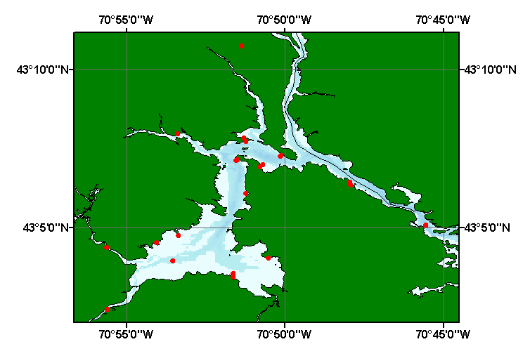
Image map showing extent and distribution of data layer coverage.
- Browse_Graphic_File_Type: GIF
- Data_Set_Credit:
-
Please view the cross reference information for the original data set credit to Nelson (1986). Larry Ward (UNH) for entering the data from the source report, and Larry Poppe for creating the ArcView shapefile.
- Native_Data_Set_Environment:
-
Microsoft Windows 2000 Version 5.1 (Build 2600) ; ESRI ArcCatalog 8.2.0.700
- Cross_Reference:
-
- Citation_Information:
-
- Originator: J.I. Nelson
- Publication_Date: 1986
- Title:
-
The presence of mercury, chromium, lead, nickle, copper, and zinc in the Great Bay estuarine system, New Hampshire
- Edition: 1.0
- Series_Information:
-
- Series_Name: Master's Thesis
- Issue_Identification: 159 p.
- Publication_Information:
-
- Publication_Place: Durham, NH
- Publisher: University of New Hampshire
- Data_Quality_Information:
-
- Attribute_Accuracy:
-
- Attribute_Accuracy_Report:
-
All attributes were checked by the compilers in a consistent manner.
- Logical_Consistency_Report:
-
No additional checks for topological consistency were performed on the data
- Completeness_Report:
-
Identifiers, navigation, and grain-size data are provided for 23 stations.
- Positional_Accuracy:
-
- Horizontal_Positional_Accuracy:
-
- Horizontal_Positional_Accuracy_Report: Navigational accuracy unknown.
- Lineage:
-
- Source_Information:
-
- Source_Citation:
-
- Citation_Information:
-
- Originator: J.I. Nelson
- Publication_Date: 1986
- Title:
-
The presence of mercury, chromium, lead, nickle, copper, and zinc in the Great Bay estuarine system, New Hampshire
- Edition: 1.0
- Series_Information:
-
- Series_Name: Master's Thesis
- Issue_Identification: 159 p.
- Publication_Information:
-
- Publication_Place: Durham,NH
- Publisher: University of New Hampshire
- Type_of_Source_Media: paper
- Source_Time_Period_of_Content:
-
- Time_Period_Information:
-
- Single_Date/Time:
-
- Calendar_Date: 1986
- Source_Currentness_Reference: publication date
- Process_Step:
-
- Process_Description:
-
The source information was manually entered into digital form and was imported from an ASCII text file to an ArcView table. The table was later converted to an event theme and saved as the final shapefile.
- Source_Used_Citation_Abbreviation: nelson86.txt
- Process_Date: 20021101
- Source_Produced_Citation_Abbreviation: nelson86.shp
- Source_Produced_Citation_Abbreviation: nelson86.shx
- Source_Produced_Citation_Abbreviation: nelson86.dbf
- Process_Contact:
-
- Contact_Information:
-
- Contact_Person_Primary:
-
- Contact_Person: Lawrence J. Poppe
- Contact_Organization: U.S. Geological Survey
- Contact_Position: Geologist
- Contact_Address:
-
- Address_Type: mailing and physical address
- Address: 384 Woods Hole Road
- City: Woods Hole
- State_or_Province: MA
- Postal_Code: 02543-1598
- Country: USA
- Contact_Voice_Telephone: 508-548-8700 x2314
- Contact_Facsimile_Telephone: 508-457-2310
- Contact_Electronic_Mail_Address: [email protected]
- Spatial_Data_Organization_Information:
-
- Direct_Spatial_Reference_Method: Vector
- Point_and_Vector_Object_Information:
-
- SDTS_Terms_Description:
-
- SDTS_Point_and_Vector_Object_Type: Entity point
- Point_and_Vector_Object_Count: 23
- Spatial_Reference_Information:
-
- Horizontal_Coordinate_System_Definition:
-
- Geographic:
-
- Latitude_Resolution: 0.00001
- Longitude_Resolution: 0.00001
- Geographic_Coordinate_Units: Decimal degrees
- Geodetic_Model:
-
- Horizontal_Datum_Name: North American Datum of 1927
- Ellipsoid_Name: Clarke 1866
- Semi-major_Axis: 6378206.400000
- Denominator_of_Flattening_Ratio: 294.978698
- Entity_and_Attribute_Information:
-
- Detailed_Description:
-
- Entity_Type:
-
- Entity_Type_Label: nelson86.dbf
- Entity_Type_Definition: Shapefile Attribute Table
- Entity_Type_Definition_Source: ESRI
- Attribute:
-
- Attribute_Label: FID
- Attribute_Definition: Internal feature number.
- Attribute_Definition_Source: ESRI
- Attribute_Domain_Values:
-
- Unrepresentable_Domain:
-
Sequential unique whole numbers that are automatically generated.
- Attribute:
-
- Attribute_Label: Shape
- Attribute_Definition: Feature geometry.
- Attribute_Definition_Source: ESRI
- Attribute_Domain_Values:
-
- Unrepresentable_Domain: Coordinates defining the features.
- Attribute:
-
- Attribute_Label: LOCAL_ID
- Attribute_Definition: Geographic name assigned to identify stations
- Attribute_Definition_Source: Scientist
- Attribute_Domain_Values:
-
- Unrepresentable_Domain: Character string of width 33.
- Attribute:
-
- Attribute_Label: REFERENCE
- Attribute_Definition: Author and year of publication
- Attribute_Definition_Source: Compiler
- Attribute_Domain_Values:
-
- Unrepresentable_Domain: Character string of width 18.
- Attribute:
-
- Attribute_Label: LATITUDE
- Attribute_Definition: Latitude coordinate of sample location
- Attribute_Domain_Values:
-
- Range_Domain:
-
- Range_Domain_Minimum: 43.04056
- Range_Domain_Maximum: 43.17917
- Attribute_Units_of_Measure: decimal degrees
- Attribute_Measurement_Resolution: 0.00001
- Attribute:
-
- Attribute_Label: LONGITUDE
- Attribute_Definition: Longitude coordinate of sample location
- Attribute_Definition_Source: Scientist
- Attribute_Domain_Values:
-
- Range_Domain:
-
- Range_Domain_Minimum: -70.92694
- Range_Domain_Maximum: -70.75917
- Attribute_Units_of_Measure: decimal degrees
- Attribute_Measurement_Resolution: 0.00001
- Attribute:
-
- Attribute_Label: SAND
- Attribute_Definition: Percentage of sand in samples
- Attribute_Definition_Source: Scientist
- Attribute_Domain_Values:
-
- Range_Domain:
-
- Range_Domain_Minimum: 5
- Range_Domain_Maximum: 95
- Attribute_Units_of_Measure: percent
- Attribute_Measurement_Resolution: 1
- Attribute:
-
- Attribute_Label: FINES
- Attribute_Definition: Percentage of fines (silt plus clay) in samples
- Attribute_Definition_Source: Scientist
- Attribute_Domain_Values:
-
- Range_Domain:
-
- Range_Domain_Minimum: 5
- Range_Domain_Maximum: 93
- Attribute_Units_of_Measure: percent
- Attribute_Measurement_Resolution: 1
- Attribute:
-
- Attribute_Label: LITHOLOGY
- Attribute_Definition: Textural descriptions of the sediment
- Attribute_Definition_Source: Compiler
- Attribute_Domain_Values:
-
- Unrepresentable_Domain: Verbal descriptions of the sediment
- Overview_Description:
- Distribution_Information:
-
- Distributor:
-
- Contact_Information:
-
- Contact_Person_Primary:
-
- Contact_Person: Lawrence J. Poppe
- Contact_Organization: U.S. Geological Survey
- Contact_Position: Geologist
- Contact_Address:
-
- Address_Type: mailing and physical address
- Address: 384 Woods Hole Road
- City: Woods Hole
- State_or_Province: MA
- Postal_Code: 02543-1598
- Country: USA
- Contact_Voice_Telephone: 508-548-8700 x2314
- Contact_Facsimile_Telephone: 508-457-2310
- Contact_Electronic_Mail_Address: [email protected]
- Resource_Description:
-
Regional Mapping of Surficial Sediments: Gulf of Maine and Georges Bank, Aggregates and Habitats Projects, nelson86.shp
- Distribution_Liability:
-
Although this data set has been used by the U.S. Geological Survey, no warranty, expressed or implied, is made by the USGS as to the accuracy of the data and/or related materials. The act of distribution shall not constitute any such warranty, and no responsibility is assumed by the USGS in the use of these data or related materials.
- Standard_Order_Process:
-
- Digital_Form:
-
- Digital_Transfer_Information:
-
- Format_Name: ArcView shapefile
- Format_Version_Number: 3.2
- Format_Specification: ESRI point shapefile
- Format_Information_Content:
-
Five files (nelson86.shp, nelson86.dbf, nelson86.shx, nelson86.sbx, nelson86.sbn) comprising the ArcView point shapefile components, 'prj' and 'avl' files, metadata text file and browse graphic.
- File_Decompression_Technique: zip
- Transfer_Size: 0.125
- Digital_Transfer_Option:
-
- Offline_Option:
-
- Offline_Media: CD-ROM
- Recording_Capacity:
-
- Recording_Density: 650
- Recording_Density_Units: Mbytes
- Compatibility_Information:
-
The user must have a computer system with a CD-ROM available. To browse the information contained on this CD-ROM, the user must have a current WWW browser available. The user must also have software installed on their computer to unzip the archived file.
- Fees: None
- Technical_Prerequisites:
-
The data is available in ArcView shapefile format. The user must have ArcView 3.0 or greater software to read and process the data file. In lieu of ArcView, the user may utilize another GIS application package capable of importing data.
- Available_Time_Period:
-
- Time_Period_Information:
-
- Single_Date/Time:
-
- Calendar_Date: 2002
- Metadata_Reference_Information:
-
- Metadata_Date: 20030216
- Metadata_Contact:
-
- Contact_Information:
-
- Contact_Person_Primary:
-
- Contact_Person: Lawrence J. Poppe
- Contact_Organization: U.S. Geological Survey
- Contact_Position: Geologist
- Contact_Address:
-
- Address_Type: mailing and physical address
- Address: 384 Woods Hole Road
- City: Woods Hole
- State_or_Province: MA
- Postal_Code: 02543-1598
- Country: USA
- Contact_Voice_Telephone: 508-548-8700 x2314
- Contact_Facsimile_Telephone: 508-457-2310
- Contact_Electronic_Mail_Address: [email protected]
- Metadata_Standard_Name: FGDC Content Standards for Digital Geospatial Metadata
- Metadata_Standard_Version: FGDC-STD-001-1998
- Metadata_Time_Convention: local time
- Metadata_Access_Constraints: None
- Metadata_Use_Constraints: None
Generated by mp version 2.7.3 on Sun Feb 16 11:38:36 2003
OFR03-001 Home | Introduction
| Nomenclature | Browse
Maps | Data Catalog | Data
Dictionary
[an error occurred while processing this directive]