Skip past header information
 Link to USGS Home Page
Geophysical Surveys of Bear Lake, Utah-Idaho, September, 2002, OFR 03-150

Skip past index

Data
Grab Samples

Nineteen grab samples were collected throughout the survey area in order to ground-truth the sidescan-sonar mosaic (Fig. 4).
Image showing grab sample and sound velocity profile locations
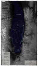
Figure 4. Map showing location of grab samples and sound velocity profiles.
All samples were sieved through a 2 mm sieve in order to separate the coarse fraction (almost all shells and shell fragments) from the fine fraction. No detailed grain-size analyses were conducted. Photographs and percent fine and coarse fraction for each sample are listed in the table below. Two photographs are displayed for grab sample 10, BL02-b10; one photograph of the entire sample, fine and coarse fractions, and a second photograph showing only the coarse fraction. High-backscatter regimes throughout the study area are characterized by high concentrations of shells, as shown by the coarse fraction of grab sample 10, BL02-b10. Low-backscatter regimes consist primarily of calcareous mud, or marl.

Grab sample locations and images are displayed below and can also be viewed within the ArcView project file stored on this CD-ROM. See GIS Data for more information.

Grab Sample Data
Sample ID Percent Fine
Fraction (%)
Percent Coarse
Fraction (%)
BL02-b1
Photograph of sediment sample
99.8 0.2
BL02-b2
Photograph of sediment sample
57.5 42.5
BL02-b3
Photograph of sediment sample
87.6 12.4
BL02-b4
Photograph of sediment sample
99.9 0.1
BL02-b5
Photograph of sediment sample
53.5 46.5
BL02-b6
Photograph of sediment sample
21.7 78.3
BL02-b7
Photograph of sediment sample
94.1 5.9
BL02-b8
Photograph of sediment sample
100.0 0.0
BL02-b9
Photograph of sediment sample
94.4 5.6
BL02-b10
Photograph of sediment sample
Photograph of coarse fraction of grab sample
58.0 42.0
BL02-b11
Photograph of sediment sample
31.9 68.1
BL02-b12
Photograph of sediment sample
76.2 23.8
BL02-b13
Photograph of sediment sample
100.0 0.0
BL02-b14
Photograph of sediment sample
45.0 55.0
BL02-b15
Photograph of sediment sample
97.0 3.0
BL02-b16
Photograph of sediment sample
98.8 1.2
BL02-b17
Photograph of sediment sample
100.0 0.0
BL02-b18
Photograph of sediment sample
100.0 0.0
BL02-b19
Photograph of sediment sample
97.9 2.1
BL02-b20
Photograph of sediment sample
99.7 0.3


To view files in PDF format, download free copy of Adobe Acrobat Reader www.adobe.com/products/acrobat/alternate.html.


Skip past footer information
Title Page / Contents / Project Description / GIS Data / Contacts

[an error occurred while processing this directive]