High-resolution seismic-reflection surveys in the nearshore of outer Cape Cod, Massachusetts, USGS Open-File Report 03-235
Back to Title Page
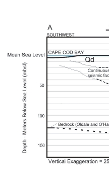
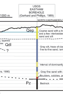
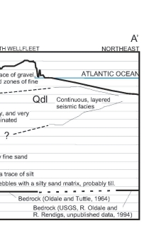
Figure 13. Geologic cross section constructed from nearshore seismic profile interpretation (Oldale and O´Hara, 1990; USGS, R. Oldale and R. Rendigs, unpublished data; This Study), a USGS deep borehole (Gerhard and Phillips, 1989), and seismic refraction data (Oldale and Tuttle, 1964). Offshore units, glacial drift (Qd), glaciolacustrine (Qdl), and Paleozoic bedrock (Pz) refer to those mapped by Oldale and O´Hara (1990). The Eastham plain deposit (Qep) is mapped on the surface by Oldale and Barlow (1986). See figure 8, figure 9, and figure 10 for cross-section location.
Click on figure for larger image (PDF format 18 KB).
 |
 |
 |
![]() To view files in PDF format, download free copy of Adobe Acrobat Reader.
To view files in PDF format, download free copy of Adobe Acrobat Reader.
