|
|
|
|
|
| Report Home | Maps | Overview | Mapping Methods | Coastal Classifications | Geologic Setting | Coastal Processes | Coastal Vulnerability | Classification Summary | References | |||||||||||||||||||||||||||||||
Southwestern Florida Coastal Classification Maps
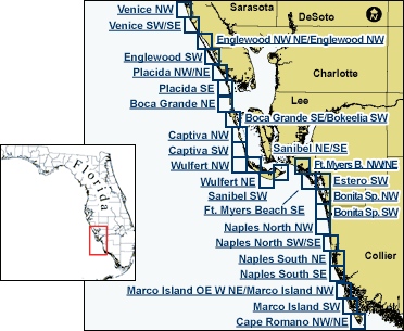
Version HistoryIn version 1.1, dates for ground observation and map verification have been corrected on the page methods.html. In version 1.2, the text describing the percentages of shoreline characterized by dune and washover terrace has been corrected on the page Classification Summary. The map at right shows the areas covered by this web site. Click on any of the location names or outlines to view the Coastal Classification Map for that area. |